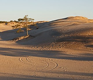
A dune is a landform composed of wind- or water-driven sand. It typically takes the form of a mound, ridge, or hill. An area with dunes is called a dune system or a dune complex. A large dune complex is called a dune field, while broad, flat regions covered with wind-swept sand or dunes with little or no vegetation are called ergs or sand seas. Dunes occur in different shapes and sizes, but most kinds of dunes are longer on the stoss (upflow) side, where the sand is pushed up the dune, and have a shorter slip face in the lee side. The valley or trough between dunes is called a dune slack.
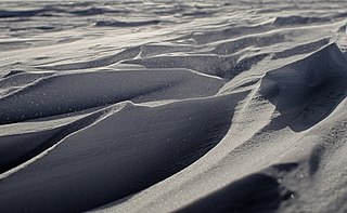
Sastrugi, or zastrugi, are features formed by erosion of snow by wind. They are found in polar regions, and in snowy, wind-swept areas of temperate regions, such as frozen lakes or mountain ridges. Sastrugi are distinguished by upwind-facing points, resembling anvils, which move downwind as the surface erodes. These points usually lie along ridges perpendicular to the prevailing wind; they are steep on the windward side and sloping to the leeward side. Smaller irregularities of this type are known as ripples or wind ridges.

A barchan or barkhan dune is a crescent-shaped dune. The term was introduced in 1881 by Russian naturalist Alexander von Middendorf, based on their occurrence in Turkestan and other inland desert regions. Barchans face the wind, appearing convex and are produced by wind action predominantly from one direction. They are a very common landform in sandy deserts all over the world and are arc-shaped, markedly asymmetrical in cross section, with a gentle slope facing toward the wind sand ridge, comprising well-sorted sand.

Pimpirev Glacier on Livingston Island in the South Shetland Islands, Antarctica is situated south of the glacial divide between the Drake Passage and Bransfield Strait, southeast of Tundzha Glacier, southwest of Saedinenie Snowfield, west of Perunika Glacier and east-northeast of Kamchiya Glacier. The feature extends 5.5 km in a southeast-northwest direction, and 1.8 km in northwest-southeast direction. The glacier drains southeastwards towards Pimpirev Beach, mostly terminating on the shore, and on several occasions penetrating the South Bay waters east-northeast of Ereby Point.

Bellhouse Provincial Park is a provincial park in the southern Gulf Islands of British Columbia, Canada. It is located in the Sturdies Bay area of southeastern Galiano Island. It is on land donated by Thorney Bellhouse many in 1964, and is noted for its spring wild flowers, notably fawn lilies and chocolate lilies, as well as views of snow-capped mountains and abundant marine life.

Snow Hill Island is an almost completely snowcapped island, 33 km (21 mi) long and 12 km (7.5 mi) wide, lying off the east coast of the Antarctic Peninsula. It is separated from James Ross Island to the north-east by Admiralty Sound and from Seymour Island to the north by Picnic Passage. It is one of several islands around the peninsula known as Graham Land, which is closer to Argentina and South America than any other part of the Antarctic continent.

Terra Cimmeria is a large Martian region, centered at 34.7°S 145°E and covering 5,400 km (3,400 mi) at its broadest extent. It covers latitudes 15 N to 75 S and longitudes 170 to 260 W. It lies in the Eridania quadrangle. Terra Cimmeria is one part of the heavily cratered, southern highland region of the planet. The Spirit rover landed near the area.
Terra Sabaea is a large area on Mars. Its coordinates are 2°N42°E and it covers 4,700 kilometres (2,900 mi) at its broadest extent. It was named in 1979 after a classic albedo feature on the planet. Terra Sabaea is fairly large and parts of it are found in five quadrangles: Arabia quadrangle, Syrtis Major quadrangle, Iapygia quadrangle, Ismenius Lacus quadrangle, and Sinus Sabaeus quadrangle.

Olympia Undae is a vast dune field in the north polar region of the planet Mars. It consists of a broad "sand sea" or erg that partly rings the north polar plateau from about 120° to 240°E longitude and 78° to 83°N latitude. Stretching about 1,100 km (680 mi) across and covering an area of 470,000 km2, Olympia Undae is the largest continuous dune field on Mars. It is similar in size to the Rub' Al Khali in the Arabian Peninsula, the largest active erg on Earth.
Aeolian landforms are features produced by either the erosive or constructive action of the wind. These features may be built up from sand or snow, or eroded into rock, snow, or ice. Aeolian landforms are commonly observed in sandy deserts and on frozen lakes or sea ice and have been observed and studied across Earth and on other planets, including Mars and Pluto

Treklyano Island is an island off the northeast coast of Robert Island, South Shetland Islands Extending 330 by 250 m, with a low rocky formation projecting 300 m (330 yd) northeastwards, the island emerged as a distinct geographical entity following the retreat of Robert Island's ice cap in the late 20th century. Named after the settlement of Treklyano in western Bulgaria.
Tatul Island is a triangular ice-free island off the north coast of Robert Island in the South Shetland Islands, Antarctica. Extending 350 by 200 m, the island emerged as a distinct geographical entity following the retreat of Robert Island's ice cap in the late 20th and early 21st century.

Maunder is an old, eroded crater on Mars, located in the Noachis quadrangle at 50 South and 358.5 West. It measures 91 kilometers in diameter and was named after British astronomer Walter Maunder in 1973.
Green is an impact crater in the Argyre quadrangle of Mars. It is named after Nathan E. Green, a British astronomer (1823-1899).
Barchan is a village in Garkan Rural District, Garkan-e Jonubi District, Mobarakeh County, Isfahan Province, Iran. As of the 2006 census, its population was 657, with there being 169 families.

Liu Hsin Crater is a crater in the Phaethontis quadrangle of Mars, located at 53.6°S latitude and 171.6°W longitude. It is 137.0 km in diameter and was named after Liu Xin. Liu Hsin was a Chinese astronomer, historian, and editor during the Western Han Dynasty and the Xin Dynasty. The name was approved in 1973 by the International Astronomical Union (IAU) Working Group for Planetary System Nomenclature (WGPSN).

Jarry-Desloges is an impact crater in the Iapygia quadrangle of Mars, located at 9.5°S latitude and 276.3°W longitude. It is 92.0 km in diameter and was named after René Jarry-Desloges, and the name was approved in 1973.

Hyperboreae Undae is one of the largest and densest dune fields of Planum Boreum, the Martian North Pole. It is named after one of the classical albedo features on Mars. Its name was officially approved by IAU in 1988. It extends from latitude 77.12°N to 82.8°N and from longitude 302.92°E to 316.02°E. Its centre is at latitude 79.96°N, longitude 49.49°W, and has a diameter of 463.65 kilometres (288.10 mi).
