
Otto von Kotzebue was a Baltic German naval officer in the Imperial Russian Navy. He commanded two naval expeditions into the Pacific for the purposes of exploration and scientific investigation. The first expedition explored Oceania and the western coast of North America and passed through the Bering Strait in search of a passage across the Arctic Ocean. His second voyage was intended as a military resupply mission to Kamchatka but again included significant explorations of the west coast of North America and Oceania.

The stork-billed kingfisher, is a tree kingfisher which is widely but sparsely distributed in the tropical Indian subcontinent and Southeast Asia, from India to Indonesia. This kingfisher is resident throughout its range.

Kaiser-Wilhelmsland formed part of German New Guinea, the South Pacific protectorate of the German Empire. Named in honour of Wilhelm I, who reigned as German Emperor from 1871 to 1888, it included the northern part of present-day Papua New Guinea. From 1884 until 1920 the territory was a protectorate of the German Empire. Kaiser-Wilhelmsland, the Bismarck Archipelago, the northern Solomon Islands, the Caroline Islands, Palau, Nauru, the Northern Mariana Islands, and the Marshall Islands comprised German New Guinea.
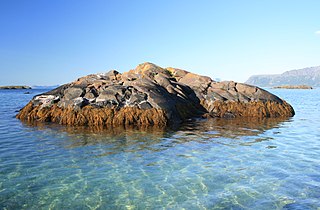
A skerry is a small rocky island, or islet, usually too small for human habitation. It may simply be a rocky reef. A skerry can also be called a low sea stack.

The Alexander Archipelago is a 300-mile (480 km) long archipelago in North America lying off the southeastern coast of Alaska. It contains about 1,100 islands, the tops of submerged coastal mountains that rise steeply from the Pacific Ocean. Deep channels and fjords separate the islands and cut them off from the mainland. The islands shelter the northern part of the Inside Passage as it winds its way among them.
Petermann Island is an island 1 nautical mile long, lying 1 nautical mile southwest of Hovgaard Island in the Wilhelm Archipelago, Antarctica.

Booth Island is a Y-shaped island, 5 nautical miles long and rising to 980 metres (3,220 ft) in the northeast part of the Wilhelm Archipelago, Antarctica.

Palmer Archipelago, also known as Antarctic Archipelago, Archipiélago Palmer, Antarktiske Arkipel or Palmer Inseln, is a group of islands off the northwestern coast of the Antarctic Peninsula. It extends from Tower Island in the north to Anvers Island in the south. It is separated by the Gerlache and Bismarck straits from the Antarctic Peninsula and Wilhelm Archipelago, respectively. The archipelago is in the British, Chilean, and Argentine Claims.

Trinity Island or Île de la Trinité or Isla Trinidad is an island 24 km (15 mi) long and 10 km (6 mi) wide in the northern part of the Palmer Archipelago, Antarctica. It lies 37 km (23 mi) east of Hoseason Island, 72.6 km (45 mi) south of Deception Island in the South Shetland Islands, and 10.3 km (6 mi) north-northwest of Cape Andreas on the Antarctic Peninsula. The island was named by Otto Nordenskiöld, leader of the 1901-1904 Swedish Antarctic Expedition (SAE) in commemoration of Edward Bransfield's "Trinity Land" of 1820.
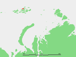
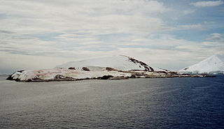
Jackson Island is an island located in Franz Josef Land, Arkhangelsk Oblast, Russian Federation. This island is part of the Zichy Land subgroup of the central part of the archipelago.

Hovgaard Island is an island 3 nautical miles long, lying 1.5 nautical miles southwest of Booth Island in the Wilhelm Archipelago, Antarctica.
The Archipelago of the Recherche, known locally as the Bay of Isles, is a group of 105 islands, and over 1200 "obstacles to shipping", off the south coast of Western Australia. The islands stretch 230 km (140 mi) from east to west and to 50 km (31 mi) off-shore encompassing an area of approximately 4,000 square kilometres (1,544 sq mi). The western group is near Esperance and the eastern group at Israelite Bay. They are located in coastal waters, part of which is designated the Recherche Archipelago Nature Reserve.
Lumus Rock is a rock located 4 nautical miles (7 km) west-northwest of Sooty Rock, marking the southwestern extremity of the Wilhelm Archipelago off the Graham Coast of the Antarctic Peninsula, Antarctica. It was discovered by British Graham Land Expedition (BGLE), 1934–37, and named "Lumus Reef" after one of the expedition cats, the only one to survive the Antarctic winter. The BGLE naming has been accepted because of long use, though a change in generic term, from reef to rock, was made on recommendation by the UK Antarctic Place-Names Committee in 1971. The rock is situated roughly midway between Anvers and Renaud Island at 7.8 miles (12.6 km) west-northwest of the Betbeder Islands, in the Hugo Island Trough, belonging to the Palmer Deep, an inner shelf structural depression.

Recreational dive sites are specific places that recreational scuba divers go to enjoy the underwater environment or for training purposes. They include technical diving sites beyond the range generally accepted for recreational diving. In this context all diving done for recreational purposes is included. Professional diving tends to be done where the job is, and with the exception of diver training and leading groups of recreational divers, does not generally occur at specific sites chosen for their easy access, pleasant conditions or interesting features.


