The Intermontane Plateaus of the Western United States is one of eight U.S. Physiographic regions (divisions) of the physical geography of the contiguous United States. The region is composed of intermontane plateaus and mountain ranges. It is subdivided into physiographic provinces, which are each subdivided into physiographic sections.

The Great Basin Desert is part of the Great Basin between the Sierra Nevada and the Wasatch Range. The desert is a geographical region that largely overlaps the Great Basin shrub steppe defined by the World Wildlife Fund, and the Central Basin and Range ecoregion defined by the U.S. Environmental Protection Agency and United States Geological Survey. It is a temperate desert with hot, dry summers and snowy winters. The desert spans a large part of the state of Nevada, and extends into western Utah, eastern California, and Idaho. The desert is one of the four biologically defined deserts in North America, in addition to the Mojave, Sonoran, and Chihuahuan Deserts.

The geology of the Grand Teton area consists of some of the oldest rocks and one of the youngest mountain ranges in North America. The Teton Range, partly located in Grand Teton National Park, started to grow some 9 million years ago. An older feature, Jackson Hole, is a basin that sits aside the range.

Places of interest in the Death Valley area are mostly located within Death Valley National Park in eastern California.
As part of New England, Connecticut has undergone much geologic change shaped by plate tectonics, volcanism, and glacial activity.

In geology, a depression is a landform sunken or depressed below the surrounding area. Depressions form by various mechanisms.

Manhattan is an unincorporated town in Nye County, Nevada, located at the end of Nevada State Route 377, about 50 miles (80 km) north of Tonopah, the county seat.
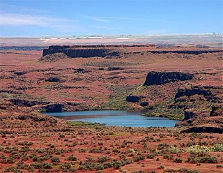
Drumheller Channels National Natural Landmark showcases the Drumheller Channels, which are the most significant example in the Columbia Plateau of basalt butte-and-basin Channeled Scablands. This National Natural Landmark is an extensively eroded landscape, located in south central Washington state characterized by hundreds of isolated, steep-sided hills (buttes) surrounded by a braided network of numerous channels, all but one of which are currently dry. It is a classic example of the tremendous erosive powers of extremely large floods such as those that reformed the Columbia Plateau volcanic terrain during the late Pleistocene glacial Missoula Floods.
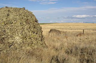
Sims Corner Eskers and Kames National Natural Landmark of Douglas County, Washington and nearby McNeil Canyon Haystack Rocks and Boulder Park natural landmarks contain excellent examples of Pleistocene glacial landforms. Sims Corner Eskers and Kames National Natural Landmark includes classic examples of ice stagnation landforms such as glacial erratics, terminal moraines, eskers, and kames. It is located on the Waterville Plateau of the Columbia Plateau in north central Washington state in the United States.

The glacial history of Minnesota is most defined since the onset of the last glacial period, which ended some 10,000 years ago. Within the last million years, most of the Midwestern United States and much of Canada were covered at one time or another with an ice sheet. This continental glacier had a profound effect on the surface features of the area over which it moved. Vast quantities of rock and soil were scraped from the glacial centers to its margins by slowly moving ice and redeposited as drift or till. Much of this drift was dumped into old preglacial river valleys, while some of it was heaped into belts of hills at the margin of the glacier. The chief result of glaciation has been the modification of the preglacial topography by the deposition of drift over the countryside. However, continental glaciers possess great power of erosion and may actually modify the preglacial land surface by scouring and abrading rather than by the deposition of the drift.

The Geology of Pennsylvania consists of six distinct physiographic provinces, three of which are subdivided into different sections. Each province has its own economic advantages and geologic hazards and plays an important role in shaping everyday life in the state. They are: the Atlantic Coastal Plain Province, the Piedmont Province, the New England Province, the Ridge and Valley Province, the Appalachian Plateau Province, and the Central Lowlands Province.
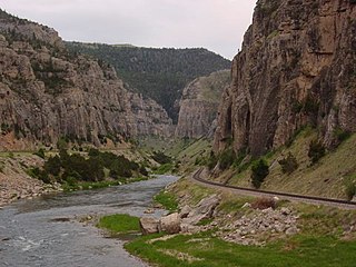
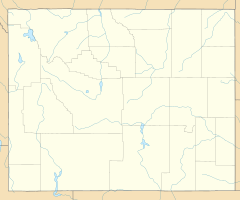
Wind River Canyon is a scenic Wyoming canyon on the Wind River. It is located between the towns of Shoshoni and Thermopolis and is a popular stop for visitors to Yellowstone National Park. It is accessible by U.S. Highway 20 and Wyoming Highway 789. It was designated as a Wyoming Scenic Byway in 2005.

The Snake River Plain ecoregion is a Level III ecoregion designated by the United States Environmental Protection Agency (EPA) in the U.S. states of Idaho and Oregon. It follows the Snake River across Idaho, stretching roughly 400 miles (640 km) from the Wyoming border to Eastern Oregon in the xeric intermontane west. Characterized by plains and low hills, it is considerably lower and less rugged than surrounding ecoregions. Many of the alluvial valleys bordering the Snake River are used for agriculture. Where irrigation water and soil depth are sufficient, sugar beets, potatoes, alfalfa, small grains, and vegetables are grown. Elsewhere, livestock grazing is widespread. Cattle feedlots and dairy operations are found locally.

The Northern Basin and Range ecoregion is a Level III ecoregion designated by the United States Environmental Protection Agency (EPA) in the U.S. states of Oregon, Idaho, Nevada, Utah, and California. It contains dissected lava plains, rolling hills, alluvial fans, valleys, and scattered mountain ranges in the northern part of the Great Basin. Although arid, the ecoregion is higher and cooler than the Snake River Plain to the north and has more available moisture and a cooler climate than the Central Basin and Range to the south. Its southern boundary is determined by the highest shoreline of Pleistocene Lake Bonneville, which once inundated the Central Basin and Range. The western part of the region is internally drained; its eastern stream network drains to the Snake River system.

Denning Crater is a large Noachian-age impact crater in the southwestern Terra Sabaea region of the southern Martian highlands, within the Sinus Sabaeus quadrangle. It is located to the northwest of the Hellas impact basin within the furthest outskirts of the Hellas debris apron. The crater is 165 km in diameter and likely formed during the Late Heavy Bombardment, a period of intense bolide impacts affecting the entirety of the Solar System; during the Hesperian period, aeolian processes caused significant degradation of the crater's rim features and infilled the crater's floor. Similar to other large craters in this region of Mars, wind-eroded features are sporadically found on the basin floor. The presence of wrinkle ridges of varying orientations within and around the Denning basin has been correlated to regional tectonic events, including the formation of the Hellas basin itself. The crater was named for British astronomer William Frederick Denning.

The Ogallala Formation is a Miocene to early Pliocene geologic formation in the central High Plains of the western United States and the location of the Ogallala Aquifer. In Nebraska and South Dakota it is also classified as the Ogallala Group. Notably, it records the North American Land Mammal Ages (NALMAs) Hemphillian, Clarendonian, and Barstovian. It also includes an excellent record of grass seeds and other plant seeds, which can be used for biostratigraphic dating within the formation. The Ogallala Formation outcrops of Lake Meredith National Recreation Area preserve fish fossils. Similar specimens from the same unit are found at Alibates Flint Quarries National Monument in Texas.
The Perris Block is the central block of three major fault-bounded blocks of the northern part of the Peninsular Ranges. The Perris Block lies between the Santa Ana Block to the west and the San Jacinto Block to the east. The Perris Block, was named by Walter A. English in 1925 for the city of Perris, located near the center of the block.
Sugar Run is a tributary of Bowman Creek in Luzerne County and Wyoming County, in Pennsylvania, in the United States. It is approximately 1.8 miles (2.9 km) long and flows through Lake Township in Luzerne County and Noxen Township in Wyoming County. The watershed of the stream has an area of 1.02 square miles (2.6 km2). The surficial geology in its vicinity consists of alluvium, alluvial fan, Wisconsinan Till, and bedrock. The stream's watershed is designated as a High-Quality Coldwater Fishery and a Migratory Fishery.
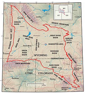
The Greater Green River Basin (GGRB) is a 21,000 square mile basin located in Southwestern Wyoming. The Basin was formed during the Cretaceous period sourced by underlying Permian and Cretaceous deposits. The GGRB is host to many anticlines created during the Laramide Orogeny trapping many of its hydrocarbon resources. It is bounded by the Rawlins Uplift, Uinta Mountains, Sevier overthrust belt, Sieria Madre Mountains, and the Wind River Mountain Range. The Greater Green River Basin is subdivided into four smaller basins the Green River Basin, Great Divide Basin, Washakie Basin, and Sand Wash Basin. Each of which possesses hydrocarbons that have been economically exploited. There are 303 named fields throughout the basin the majority of which produce natural gas, the largest of these gas fields is the Jonah Field.