The Great Northern Railway Trail

Last updated

The Great Northern Railway Trail
Hewenden Viaduct - geograph.org.uk - 1592068.jpg
Hewenden Viaduct looking north - the deck has been tarmacked for The Great Northern Railway Trail
Length6.2 miles (10 km)
Established2005
DesignationUK National Cycle Route 69
Trailheads Cullingworth
Queensbury
UseCycling, pedestrians, horse trail
Surface Tarmacked (on designated sections)

The Great Northern Railway Trail is a cycleway and footpath in the Bradford District of West Yorkshire, England. The path follows the route of a former railway, that of the Great Northern railway line between Bradford and Keighley that went via Queensbury and Cullingworth. The path has been designated as part of the National Cycle Route number 69.

Contents

History

The Great Northern Railway (GNR) opened up its lines connecting Bradford, Halifax and Keighley between 1878 and 1884. [1] This involved a triangular junction at Queensbury railway station. As the GNR lines were built after other railways had been constructed in the valleys, many of their lines were built to traverse the high valley sides and as such, had many steep gradients and tunnels which led to them acquiring the nickname of The Alpine Lines. [2]

Passenger traffic on these lines had ceased by 1955, with complete closure of the lines by 1972 and much of the trackbed was abandoned and the tunnels bricked up. In 2005, Sustrans and Bradford Council re-opened a section of the former track from the site of Cullingworth railway station to the former station of Wilsden as the Great Northern Railway Trail. In 2008, a smaller section through Thornton village and across the viaduct there was opened, [3] along with a second stretch between the former Queensbury railway station and a point just south of Thornton Viaduct. [4] The final stretch to connect the two sections from Thornton Viaduct to the former station site at Queensbury opened in October 2012. [5]

Eventually the trail will cover 6.2 miles (10 km), [6] but currently this is split into two sections some 2 miles (3.5 km) apart. [7] Although the whole trail is seen as one through route, only the sections between Cullingworth and Hewenden Viaduct, and Queensbury station and the northern edge of Thornton Viaduct are designated clear of road traffic. The section between these two is accomplished on footpaths for walkers, but cycle traffic must take to local roads to connect between the two sections. [8]

Sign at the start of the trail in Cullingworth GNRT (2124586429).jpg
Sign at the start of the trail in Cullingworth

Since the initial re-opening in 2005, smaller sections have opened in a piecemeal fashion which add to either end of the two split sections. [9] The route connects with two other long distance paths; the Calder/Aire Bridleway in Cullingworth [10] and the Bronte Way at Thornton. [7]

Infrastructure

There are three viaducts on the route; Cullingworth, [11] Hewenden and Thornton. [12] Both Hewenden and Thornton viaducts are grade II listed structures [13] [14] and Thornton is particularly noted for its 'S' shaped curvature and its views over the Pinch Beck valley. [15] A platform has been installed at Hewenden to allow for a greater views across the viaduct and westwards across Hewenden reservoir. [16]

The missing section between the south end of Hewenden Viaduct and the north end of Thornton viaduct includes five disused tunnels; Well Head (662 yards (605 m)), Hamer's Hill (153 yards (140 m)), Doe Park No 1 (140 yards (130 m)), Doe Park No 2 (33 yards (30 m)) and Doe Park No 3 (112 yards (102 m)). [16]

Future

Sustrans, Bradford Council and local campaigners are all lobbying to get the route opened fully between Bradford and Keighley, with an extension through the 2,501-yard (2,287 m) long Queensbury tunnel towards Halifax. [17] A Sustrans report into re-opening the route (and Queensbury Tunnel) revealed that the best case scenario would cost £11.6 million over 30 years, but this would yield £37.6 million in economic, health and tourism benefits over the same time period. [18] [19]

Because of damage inside Queensbury tunnel and the lack of maintenance, the current owners of the tunnel (National Highways Historical Railways Estate) have suggested that the tunnel be sealed off with concrete which would cost £3 million. Campaigners state that it would be more beneficial for the community to convert the tunnel into the longest underground cycleway in Europe. The southern portal of the tunnel is in a deep cutting and is prone to flooding (as deep as 40 feet (12 m) of water at times) and so would need remediation to make it safe again. [20]

An extension south westwards from Queensbury is planned (with or without the tunnel) to Holmfield in Halifax. [21]

Related Research Articles

<span class="mw-page-title-main">Thornton, West Yorkshire</span> Village in West Yorkshire, England

Thornton is a village and former civil parish, within the metropolitan borough of the City of Bradford, in West Yorkshire, England. It lies 6 miles (9.7 km) to the west of the city centre of Bradford, and together with neighbouring Allerton, had a total resident population in 2001 of 15,004, increasing to 17,276 at the 2011 Census. Its most famous residents were the Brontës.

<span class="mw-page-title-main">Cullingworth</span> Village and civil parish in West Yorkshire, England

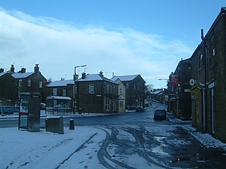
Cullingworth is a village and civil parish in the City of Bradford, West Yorkshire, England. Within the boundaries of the historic West Riding of Yorkshire, it is 7 miles (11 km) west of Bradford and 3 miles (5 km) south of Keighley. The surrounding countryside is mainly used for sheep and cattle farming, with areas of moorland lying to the north and west.

<span class="mw-page-title-main">Queensbury, West Yorkshire</span> Village in West Yorkshire, England

Queensbury is a village in the metropolitan borough of Bradford, West Yorkshire, England. Perched on a high vantage point above Halifax, Clayton and Thornton and overlooking Bradford, Queensbury is one of the highest parishes in England, with views beyond the West Yorkshire conurbation to the hills of Brontë Country and the Yorkshire Dales to the north and north west. It's population of 8,718 in 2001 increased to 16,273 in the 2011 Census.

<span class="mw-page-title-main">Halifax railway station (England)</span> Railway station in West Yorkshire, England

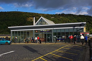
Halifax railway station serves the town of Halifax in West Yorkshire, England. It lies on the Calder Valley line and is 17 miles (27 km) west from Leeds.

<span class="mw-page-title-main">Denholme</span> Town and civil parish in West Yorkshire, England

Denholme is a town and civil parish in the Bradford Metropolitan Borough, West Yorkshire, England. It is 8 miles (13 km) west of Bradford, 7 miles (11 km) from Keighley and roughly the same distance from Halifax. Administratively, it is part of the Bingley Rural ward of the City of Bradford. Denholme has a population of 2,976, increasing to 3,489 at the 2011 Census.

The Monsal Trail is a cycling, horse riding and walking trail in the Derbyshire Peak District. It was constructed from a section of the former Manchester, Buxton, Matlock and Midland Junction Railway, which was built by the Midland Railway in 1863 to link Manchester with London and closed in 1968. The Monsal Trail is about 8.5 miles (13.7 km) long and opened in 1981. It starts at the Topley Pike junction in Wye Dale, 3 miles (4.8 km) east of Buxton, and runs to Coombs Viaduct, 1 mile (1.6 km) south-east of Bakewell. It follows the valley of the River Wye. The trail passes through Blackwell Mill, Chee Dale, Millers Dale, Cressbrook, Monsal Dale, Great Longstone, Hassop and Bakewell. The trail has numerous landmarks including Headstone Viaduct, Cressbrook Mill, Litton Mill and Hassop railway station, and passes through six tunnels.

The Queensbury lines was the name given to a number of railway lines in West Yorkshire, England, that linked Bradford, Halifax and Keighley via Queensbury. All the lines were either solely owned by the Great Northern Railway (GNR) or jointly by the GNR and the Lancashire and Yorkshire Railway (L&YR). The terrain was extremely challenging for railway construction, and the lines were very expensive to build. The lines were

<span class="mw-page-title-main">Queensbury railway station</span> Disused railway station in West Yorkshire, England

Queensbury railway station was a station on the Queensbury lines serving the village of Queensbury, West Yorkshire, England. The station was unusual due to its triangular shape, and at its opening the only other examples of this arrangement were Ambergate station in Derbyshire and Earlestown in Lancashire; since then Shipley station, also in West Yorkshire, has gained platforms on all three sides. Of the stations on the Queensbury lines, this was the most ambitious.

<span class="mw-page-title-main">St Dunstans railway station</span> Disused railway station in West Yorkshire, England

St Dunstans railway station is a closed station in the city of Bradford, West Yorkshire, England. The station was the location of a three-way junction with platforms on two of the lines.

<span class="mw-page-title-main">Thornton Viaduct</span> Disused railway viaduct in West Yorkshire, England

Thornton Viaduct is a disused railway viaduct crossing Pinch Beck valley at Thornton, in the City of Bradford, West Yorkshire, England. It is 300 yards (270 m) long and has 20 arches. It was built in an S-shape to allow a smooth access to Thornton station. The viaduct was part of the GNR's Queensbury Lines running between Queensbury and Keighley. It stopped carrying passengers in 1955 but remained open to goods until the 1960s. At that time, the railway closed and the tracks were pulled up. The viaduct is now a Grade II listed building.

<span class="mw-page-title-main">Wilsden railway station</span> Disused railway station in West Yorkshire, England

Wilsden railway station was a station on the Queensbury Lines which ran between Keighley, Bradford and Halifax.

<span class="mw-page-title-main">Denholme railway station</span> Disused railway station in West Yorkshire, England

Denholme railway station was a station on the Keighley-Queensbury section of the Queensbury Lines which ran between Keighley, Bradford and Halifax via Queensbury.

<span class="mw-page-title-main">Thornton railway station</span> Disused railway station in West Yorkshire, England

Thornton railway station was a station on the Keighley-Queensbury section of the Queensbury Lines which ran between Keighley, Bradford and Halifax via Queensbury. The station served the village of Thornton, West Yorkshire, England from 1878 to 1955.

<span class="mw-page-title-main">Cullingworth railway station</span> Disused railway station in West Yorkshire, England

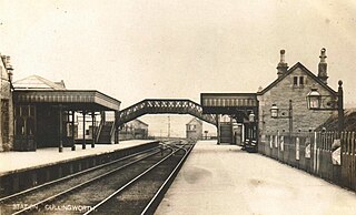
Cullingworth railway station was a station on the Queensbury Lines which ran between Keighley, Bradford and Halifax. The station served the village of Cullingworth, West Yorkshire, England. It opened for passengers in 1884 and closed in May 1955. Goods traffic continued until 1963, when the surviving line closed completely.

Clayton railway station was on the Great Northern Railway lines to Bradford, Keighley and Halifax via Queensbury, collectively known as the Queensbury Lines.

Great Horton railway station was a railway station on the Queensbury-Bradford section of the Queensbury Lines which ran between Bradford, Keighley and Halifax via Queensbury. The station opened for passengers in 1878 and closed on 23 May 1955 but remained open to goods with full staff until 28 June 1965 before it was closed, then demolished and the branch line tracks ripped up.

<span class="mw-page-title-main">Hewenden Viaduct</span> Former railway viaduct in West Yorkshire, England

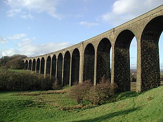
Hewenden Viaduct, situated near Cullingworth, West Yorkshire, England, originally served as a railway viaduct along the Queensbury Lines. Being one of the highest viaducts in Britain, it has been recognised as a Grade II listed structure.

<span class="mw-page-title-main">National Cycle Route 69</span> Cycle route in the United Kingdom

National Cycle Network (NCN) Route 69 is a Sustrans National Route that runs from Hest Bank to Cleethorpes. The route is incomplete and consists of one long section in Lancashire, and seven short sections in West Yorkshire. The open sections are signed in both directions.

<span class="mw-page-title-main">Lees Moor Tunnel</span> Disused railway tunnel in West Yorkshire, England

Lees Moor Tunnel is an abandoned tunnel on the former Great Northern Railway line between Queensbury and Keighley in West Yorkshire, England. The former dual track tunnel is just north of the village of Cullingworth in West Yorkshire and when built was 1,533 yards (1,402 m) long. Due to the pitch black inside and the squealing of the wheels on the 1 in 50 radius curve, drivers nicknamed it the 'Hell Hole'. After closure to passengers, the tunnel was used in experiments involving the effects of smoke inhalation and cancer.

<span class="mw-page-title-main">Queensbury Tunnel</span> Disused railway tunnel in West Yorkshire, England

Queensbury Tunnel is a disused railway tunnel that connects Holmfield and Queensbury in West Yorkshire, England. It was built by the Great Northern Railway (GNR) and, at 2,287 m (7,503 ft) in length, was the longest on the company's network at the time of its opening in 1878. The line through the tunnel closed in 1956.

References

  1. Cobb, M H (2003). The railways of Great Britain : a historical atlas at a scale of 1 inch to 1 mile vol. 2. Shepperton: Ian Allan Publishing. p. 395. ISBN   0-7110-3003-0.
  2. "Highs and lows of 'alpine route'". Bradford Telegraph and Argus. 24 May 2005. Retrieved 21 September 2017.
  3. "Hundreds to visit 'spectacular trail'". Keighley News. 25 November 2008. Retrieved 22 September 2017.
  4. "Viaduct vistas to be enjoyed soon". The Yorkshire Post. 11 August 2008. Retrieved 22 September 2017.
  5. "New section of Sustrans rail trail is opened". Keighley News. 20 October 2012. Retrieved 22 September 2017.
  6. "BBC - Bradford and West Yorkshire - Features - The Great Northern Trail reopened". www.bbc.co.uk. May 2005. Retrieved 22 September 2017.
  7. 1 2 "288" (Map). Bradford & Huddersfield. 1:25,000. Explorer. Ordnance Survey. 2015. ISBN   9780319244852.
  8. "Great Northern Railway Trail" (PDF). bradford.gov.uk. Sustrans. p. 1. Retrieved 22 September 2017.
  9. Thomas, Rhys (1 August 2013). "Pupil set to open new Great Northern Railway Trail cycle route". Keighley News. Retrieved 22 September 2017.
  10. "Keighley link to the Calder/Aire Bridleway route at Bingley St. Ives" (PDF). thedms.co.uk. Bradford Council. p. 6. Retrieved 26 September 2017.
  11. Knights, David (22 September 2016). "Cullingworth councillors check out state of Great Northern RailwayTrail following nearby building work". Keighley News. Retrieved 22 September 2017.
  12. "Disused Stations: Cullingworth Station". www.disused-stations.org.uk. Retrieved 22 September 2017.
  13. Historic England. "Hewenden Viaduct (Grade II) (1199507)". National Heritage List for England . Retrieved 22 September 2017.
  14. Historic England. "Thornton Railway Viaduct (Grade II) (1151855)". National Heritage List for England . Retrieved 22 September 2017.
  15. "Great Northern Railway Trail" (PDF). bradford.gov.uk. Sustrans. p. 2. Retrieved 22 September 2017.
  16. 1 2 Bairstow, Martin (2015). The Great Northern Railway in the West Riding; the Queensbury Lines. Farsley: Bairstow. p. 62. ISBN   978-1-871944-44-0.
  17. Mason, David (11 July 2017). "Future of historic tunnel up for debate at pub". Keighley News. Retrieved 22 September 2017.
  18. "News Releases - Study examines economic case for tunnel path". www.queensburytunnel.org.uk. Retrieved 22 September 2017.
  19. Wilde, Claire (17 August 2017). "VIDEO: New study looks at costs and benefits of ambitious rail tunnel cycle path plan". Bradford Telegraph and Argus.
  20. Stokes, Spencer (20 February 2014). "Tunnel vision for Pennine cyclists". BBC News. Retrieved 22 September 2017.
  21. Vintner, Jeff (2017). Vinter's Railway Gazetteer: A Guide to Britain's Old Railways That You Can Walk or Cycle (2 ed.). Stroud: The History Press. p. 101. ISBN   978-0-7509-6976-5.