Related Research Articles
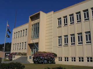
Curry County is the southwesternmost county in the U.S. state of Oregon. As of the 2020 census, the population was 23,446. The county seat is Gold Beach. The county is named for George Law Curry, a two-time governor of the Oregon Territory. Curry County includes the Brookings, OR Micropolitan Statistical Area.
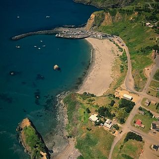
Port Orford is a city in Curry County on the southern coast of Oregon, United States. The population was 1,133 at the 2010 census.

The Oregon Coast is a coastal region of the U.S. state of Oregon. It is bordered by the Pacific Ocean to its west and the Oregon Coast Range to the east, and stretches approximately 362 miles (583 km) from the California state border in the south to the Columbia River in the north. The region is not a specific geological, environmental, or political entity, and includes the Columbia River Estuary.
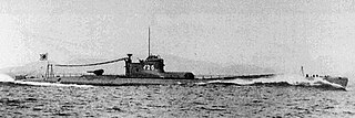
I-25 (イ-25) was a B1 type (I-15-class) submarine of the Imperial Japanese Navy that served in World War II, took part in the Attack on Pearl Harbor, and was the only Axis submarine to carry out aerial bombing on the continental United States in World War II, during the so-called Lookout Air Raids, and the shelling of Fort Stevens, both attacks occurring in the state of Oregon.

Cape Blanco is a prominent headland on the Pacific Ocean coast of southwestern Oregon in the United States, forming the westernmost point in the state. Cape Blanco extends further west than any point of land in the contiguous United States except portions of the Olympic Peninsula in Washington, including Cape Alava, the true westernmost point. The cape is part of Cape Blanco State Park and is the location of the Cape Blanco Light, first lit in 1870.

The Elk River is in southwestern Oregon in the United States. About 29 miles (47 km) long, the river drains a remote 92-square-mile (240 km2) area of the Coast Range into the Pacific Ocean.

The Oregon Coast Trail (OCT) is a long-distance hiking route along the Pacific coast of the U.S. state of Oregon in the United States. It follows the coast of Oregon from the mouth of the Columbia River to the California border south of Brookings.

U.S. Route 101 (US 101), is a major north–south U.S. Highway in Oregon that runs through the state along the coastline near the Pacific Ocean. It runs from the California border, south of Brookings, to the Washington state line on the Columbia River, between Astoria, Oregon, and Megler, Washington.

Heceta Head is a headland that stands 1,000 feet (300 m) above the Pacific Ocean in Lane County, Oregon, United States. The Heceta Head Light is located on its south side. Heceta Head is named after a Basque explorer under Spanish commission, Bruno de Heceta, who explored the Pacific Northwest in the 1770s. The headland marks the end of a lower-lying stretch of the coastline to the south dominated by sand dunes; the coastline to the north is more varied. Devils Elbow is the bay south of the headland at the mouth of Cape Creek, and with the headland formed Devils Elbow State Park, which is now part of Heceta Head Lighthouse State Scenic Viewpoint.

Port Orford Heads State Park is a coastal state park in northwest Curry County, Oregon, United States, in the city of Port Orford. Established in 1976, it is administered by the Oregon Parks and Recreation Department.

Cape Perpetua is a large forested headland projecting into the Pacific Ocean on the central Oregon Coast in Lincoln County, Oregon. The land is managed by the United States Forest Service as part of the Siuslaw National Forest.
Carl G. Washburne Memorial State Park is a state park in the U.S. state of Oregon, administered by the Oregon Parks and Recreation Department. This park is in Lane County near Florence and Yachats. Very scenic wide beach, great for dogs, kids, kites. Some areas nearby are SNOWY PLOVER protected breeding areas, where dogs are banned, so be careful to keep dogs leashed if uncertain, and always in the State Park itself.
Myrtle Creek is a small stream, about 3 miles (5 km) long, in Curry County in the U.S. state of Oregon. It arises in the Siskiyou Mountains and flows generally southwest to its confluence with Mussel Creek in the Arizona Beach State Recreation Site. The two creeks flow under U.S. Highway 101 and through the park, where they merge and enter the Pacific Ocean about 10 miles (16 km) south of Port Orford.
Mussel Creek is a small stream, about 4 miles (6 km) long, in Curry County in the U.S. state of Oregon. It arises in the Siskiyou Mountains and flows generally west to its confluence with Myrtle Creek in the Arizona Beach State Recreation Site. The creeks flow under U.S. Highway 101 and through the park, where they merge and enter the Pacific Ocean about 10 miles (16 km) south of Port Orford.
Camp Castaway was a military encampment at what is now Coos Bay, Oregon, United States. It was established by the survivors of the wreck of the Captain Lincoln, a U.S. transport schooner, on January 3, 1852. The ship began taking on water during a storm while en route from San Francisco to Fort Orford at the town of Port Orford. To avoid sinking, the captain decided to beach the ship north of Cape Arago. All of the roughly 30 troops on board, and the ship's crew, survived the wreck and most of the cargo was salvaged. At the time no U.S. settlement was present at Coos Bay, so commanding officer Lt. Henry Stanton decided to establish the camp to protect the cargo until it could be transported to Fort Orford, some 50 miles south on the Oregon Coast. The troops and crew used spars, booms and sail cloth from the schooner to build tent structures for housing and for protecting the cargo from winter rains and blowing sand. They named the temporary post Camp Castaway. The camp endured for four months in the open dunes with help from Native Americans of the Coos tribe who traded fresh foods to the soldiers for silverware, biscuits and other nonlocal goods.
From 1577 to 1580 Sir Francis Drake circumnavigated the world. In 1579 as part of this voyage he landed on the west coast of North America which consequently has drawn the attention of scores of historians, geographers, linguists, anthropologists and other professionals. In addition, many history buffs have sought to locate Drake's New Albion. The established site for Drake's 1579 landing at New Albion is at Drake's Cove in Drakes Bay in Marin County, California. More than a score of ideas for an alternative to Drake's New Albion claim have been put forth which cover the coast from Alaska to Baja California Sur, Mexico. These ideas span the eighteenth through the early twenty-first centuries.

The Pacific Northwest coast of North America was one of the last coastlines reached by European explorers. In terms of sailing time from Europe, it was one of the most distant places on earth. This article covers what Europeans knew or thought they knew before the area was explored by Captain Cook in 1778.

Floras Lake is a natural 236-acre (96 ha) body of water on the southern Oregon Coast of the United States. Fed by four small tributaries from a basin of about 10 square miles (26 km2) in Curry County, it lies about 10 miles (16 km) north of Port Orford and 2 miles (3 km) west of U.S. Route 101. It was probably named for Fred Flora, a 19th-century settler and miner who lived nearby.

Orford Reef is a reef located off Cape Blanco on the southern coast of Oregon in the United States. The reef is situated around eight small rock islands: Best Rock, Long Brown Rock, Unnamed Rock, Square White Rock, Seal Rock, Conical White Rock, West Conical Rock, and Arch Rock.
References
Coordinates: 42°44′22″N124°30′36″W / 42.739553°N 124.510105°W
| | This Curry County, Oregon state location article is a stub. You can help Wikipedia by expanding it. |