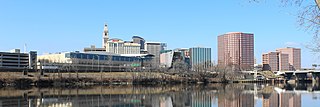
Hartford is the capital city of the U.S. state of Connecticut. It was also the seat of Hartford County, until Connecticut disbanded county government in 1960.

Fairfield County is a county in the southwestern corner of the U.S. state of Connecticut. It is the most populous county in the state and was also its fastest-growing from 2010 to 2020. As of the 2020 census, the county's population was 957,419, representing 26.6% of Connecticut's overall population. The closest to the center of the New York metropolitan area, the county contains four of the state's top 7 largest cities—Bridgeport (1st), Stamford (2nd), Norwalk (6th), and Danbury (7th)—whose combined population of 433,368 is nearly half the county's total population.
Monroe is a town located in eastern Fairfield County, Connecticut, United States. The population was 18,825 at the 2020 census. The town is part of the Greater Bridgeport Planning Region.

Enfield is a town in Hartford County, Connecticut, United States, first settled by John and Robert Pease of Salem, Massachusetts Bay Colony. The town is part of the Capitol Planning Region. The population was 42,141 at the 2020 census. It is bordered by Longmeadow, Massachusetts, and East Longmeadow, Massachusetts, to the north, Somers to the east, East Windsor and Ellington to the south, and the Connecticut River to the west.

Stamford is a city in Fairfield County, Connecticut, 34 miles outside of New York City. It is the largest city in the Western Connecticut Planning Region, and Connecticut's second-most populous city, behind Bridgeport. With a population of 135,470, Stamford passed Hartford and New Haven in population as of the 2020 census. It is in the Bridgeport-Stamford-Norwalk-Danbury metropolitan statistical area, which is part of the New York City metropolitan area.
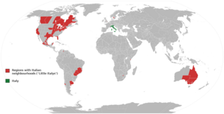
Little Italy is the catch-all name for an ethnic enclave populated primarily by Italians or people of Italian ancestry, usually in an urban neighborhood. The concept of "Little Italy" holds many different aspects of the Italian culture. There are shops selling Italian goods as well as Italian restaurants lining the streets. A "Little Italy" strives essentially to have a version of the country of Italy placed in the middle of a large non-Italian city. This sort of enclave is often the result of periods of Italian immigration, during which people of the same culture settled or were ostracized and segregated together in certain areas. As cities modernized and grew, these areas became known for their ethnic associations, and ethnic neighborhoods like "Little Italy" blossomed, becoming the areas they are today.

Middletown is a city in Middlesex County, Connecticut, United States. Located along the Connecticut River, in the central part of the state, it is 16 miles south of Hartford. Middletown is the largest city in the Lower Connecticut River Valley Planning Region. In 1650, it was incorporated by English settlers as a town under its original Native American name, Mattabeseck, after the local indigenous people, also known as the Mattabesett. They were among the many tribes along the Atlantic coast who spoke Algonquian languages. The colonists renamed the settlement in 1653.
Bridgeport is one of the 77 community areas in Chicago, on the city's South Side, bounded on the north by the South Branch of the Chicago River, on the west by Bubbly Creek, on the south by Pershing Road, and on the east by the Union Pacific railroad tracks. Neighboring communities are Pilsen across the river to the north, McKinley Park to the west, Canaryville to the south, and Armour Square to the east. Bridgeport has been the home of five Chicago mayors. Once known for its racial intolerance, Bridgeport today ranks as one of the city's most diverse neighborhoods.

The University of Bridgeport is a nonprofit private university in Bridgeport, Connecticut. The university is accredited by the New England Commission of Higher Education. In 2021, the university was purchased by Goodwin University; it retained its own name, brand, and board of trustees.

The Diocese of Bridgeport is a Latin Church ecclesiastical jurisdiction or diocese of the Catholic Church located in the southwestern part of the state of Connecticut in the United States. It is a suffragan diocese in the ecclesiastical province of the metropolitan Archdiocese of Hartford.

Bridgeport-Stamford-Norwalk is a metropolitan area in the U.S. state of Connecticut. The area is located in Southwestern Connecticut. In its most conservative form the area consists of the city of Bridgeport and five surrounding towns—Easton, Fairfield, Monroe, Stratford, and Trumbull. This definition of the Bridgeport area has a population of more than 305,000 and is within the Bridgeport-Stamford-Norwalk-Danbury metropolitan statistical area, which consists of all of Fairfield County, Connecticut. The estimated 2015 county population was 948,053. The area is numbered as part of the New York-Newark Combined Statistical Area NY-NJ-CT-PA by the United States Census Bureau.
Jamaican Americans are an ethnic group of Caribbean Americans who have full or partial Jamaican ancestry. The largest proportions of Jamaican Americans live in South Florida and New York City, both of which have been home to large Jamaican communities since the 1950s and 60s. There are also communities of Jamaican Americans residing in Connecticut, Georgia, New Jersey, Pennsylvania, Maryland, Massachusetts, and California.

The history of Bridgeport, Connecticut was, in the late 17th and most of the 18th century, one of land acquisitions from the native inhabitants, farming and fishing. From the mid-18th century to the mid-19th century, Bridgeport's history was one of shipbuilding, whaling and rapid growth. Bridgeport's growth accelerated even further from the mid-19th century to the mid-20th century with the advent of the railroad, Industrialization, massive immigration, labor movements until, at its peak population in 1950, Bridgeport with some 159,000 people was Connecticut's second most populous city. In the late 20th century, Bridgeport's history was one of deindustrialization and declining population, though it overtook Hartford as the state's most populous city by 1980.

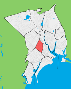
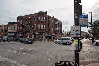
Little Italy is a neighborhood located in the North End of Bridgeport, Connecticut on Madison Avenue, near the Fairfield County Correctional Facility and Central High School, with a high Italian-American population.
According to the 2018 American Community Survey, New England had an estimated population of 14,853,290, of which 48.7% were male and 51.3% were female. Approximately 19.7% of the population were under 18 years of age; 17.4% were 65 years of age or over.
Bridgeport is the most populous city in the U.S. state of Connecticut and the fifth-most populous city in New England, with a population of 148,654 in 2020. Located in eastern Fairfield County at the mouth of the Pequonnock River on Long Island Sound, it is a port city 60 miles (97 km) from Manhattan and 40 miles (64 km) from The Bronx. It is bordered by the towns of Trumbull to the north, Fairfield to the west, and Stratford to the east. Bridgeport and other towns in Fairfield County make up the Greater Bridgeport Planning Region, as well as the Bridgeport–Stamford–Norwalk–Danbury metropolitan statistical area, the second largest metropolitan area in Connecticut. The Bridgeport–Stamford–Norwalk–Danbury metropolis forms part of the New York metropolitan area.
Seaside Park, located in Bridgeport, Connecticut, is a 2.5-mile (4.0 km) long crescent-shaped park bordering Bridgeport Harbor, Long Island Sound, and Black Rock Harbor. The park lies within Bridgeport's South End neighborhood.

The Mary and Eliza Freeman Houses are historic residences in Bridgeport, Connecticut. The simple, clapboard-covered dwellings were built in 1848 in what became known as Little Liberia, a neighborhood settled by free blacks starting in the first quarter of the nineteenth century. As the last surviving houses of this neighborhood on their original foundations, these were added to the National Register of Historic Places on February 22, 1999. The houses are the oldest remaining houses in Connecticut built by free blacks, before the state completed its gradual abolition of slavery in 1848. The homes and nearby Walter's Memorial A.M.E. Zion Church are also listed sites on the Connecticut Freedom Trail.

There have been a variety of ethnic groups in Baltimore, Maryland and its surrounding area for 12,000 years. Prior to European colonization, various Native American nations have lived in the Baltimore area for nearly 3 millennia, with the earliest known Native inhabitants dating to the 10th millennium BCE. Following Baltimore's foundation as a subdivision of the Province of Maryland by British colonial authorities in 1661, the city became home to numerous European settlers and immigrants and their African slaves. Since the first English settlers arrived, substantial immigration from all over Europe, the presence of a deeply rooted community of free black people that was the largest in the pre-Civil War United States, out-migration of African-Americans from the Deep South, out-migration of White Southerners from Appalachia, out-migration of Native Americans from the Southeast such as the Lumbee and the Cherokee, and new waves of more recent immigrants from Latin America, the Caribbean, Asia and Africa have added layers of complexity to the workforce and culture of Baltimore, as well as the religious and ethnic fabric of the city. Baltimore's culture has been described as "the blending of Southern culture and [African-American] migration, Northern industry, and the influx of European immigrants—first mixing at the port and its neighborhoods...Baltimore’s character, it’s uniqueness, the dialect, all of it, is a kind of amalgamation of these very different things coming together—with a little Appalachia thrown in...It’s all threaded through these neighborhoods", according to the American studies academic Mary Rizzo.
The history of Hispanics and Latinos in Baltimore dates back to the mid-20th century. The Hispanic and Latino community of Baltimore is the fastest growing ethnic group in the city. There is a significant Hispanic/Latino presence in many Southeast Baltimore neighborhoods, particularly Highlandtown, Upper Fell's Point, and Greektown. Overall Baltimore has a small but growing Hispanic population, primarily in the Southeast portion of the area from Fells Point to Dundalk.