The Mechanic Street Historic District encompasses a historic 19th-century mill and mill village in a 14-block area of the Pawcatuck section of Stonington, Connecticut. Extending along the Pawcatuck River and south of West Broad Street, the area includes a large brick mill complex on the banks of the river, and a neighborhood of well-preserved worker housing on the road grid to its west. The district was listed on the National Register of Historic Places in 1988.
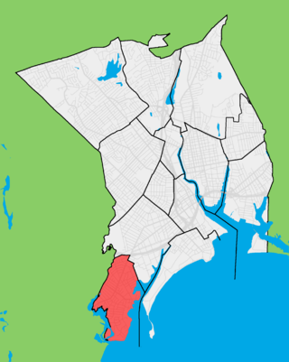
Black Rock is a neighborhood in the southwestern section of the city of Bridgeport, Connecticut. It borders Fairfield and the Ash Creek tidal estuary on the west, the West Side/West End of Bridgeport on the north and east, and Black Rock Harbor and Long Island Sound on the south. Black Rock comprises census tracts 701 and 702 and part of census tract 703. It includes two historic districts listed on the National Register of Historic Places. Residences comprise 86% of properties in Black Rock, 10% are commercial, and 4% are industrial or other property classes.
The Somersville Historic District encompasses the historic components of the mill village of Somersville in western Somers, Connecticut, United States. The district is centered on a mill complex on the Scantic River, which divides the district. The most significant years of development were between about 1835 and 1935, although the area has a history dating to the 1760s. The district was listed on the National Register of Historic Places in 1995. The Mill itself has since burned down and as of October 2018 is currently open field, although the canal structure remains in place.
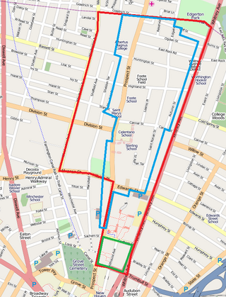
Prospect Hill is a neighborhood of the city of New Haven, Connecticut located in the north central portion of the city, directly north of Downtown New Haven. The neighborhood contains residences, institutional buildings of Albertus Magnus College and a portion of the main campus of Yale University, including the Science Hill area, the Hillhouse Avenue area and the Yale Peabody Museum. The City of New Haven defines the neighborhood to be the region bounded by the town of Hamden in the north, Winchester Avenue in the west, Munson Street/Hillside Place/Prospect Street in the southwest, Trumbull Street in the south, and Whitney Avenue in the east. Prospect Street is the main thoroughfare through the neighborhood.

The Whitney Avenue Historic District is a historic district in the East Rock neighborhood of New Haven, Connecticut. It is a 203-acre (82 ha) district which included 1,084 contributing buildings when it was listed on the National Register of Historic Places in 1989.

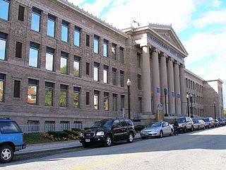
The Winchester Repeating Arms Company Historic District is a historic district in New Haven, Connecticut that was listed on the National Register of Historic Places in 1988. It includes 867 properties, which "include 858 major structures and 131 notable outbuildings." Of these structures, 876 are buildings deemed to contribute to the historical and/or architectural significance of the area, and most of these are residential. However the center of the district is "dominated" by the 75-acre (30 ha) tract of the former Winchester Repeating Arms Company, which contains industrial buildings.

The Freeman's Grove Historic District is a residential historic district in North Adams, Massachusetts. It encompasses a neighborhood north of the city center that is a well-preserved instance of a working class area developed during its industrial heyday in the late 19th century. It includes the Chase Hill Estate as well as all the houses on Chase Avenue, Bracewell Street, Hall Street and several smaller streets adjacent to those. It is roughly bounded by Liberty Street, Eagle Street, Bracewell Avenues and Houghton Street. The district was listed on the National Register of Historic Places in 1985.

The Andover Village Industrial District encompasses one of the 19th century industrial mill villages of Andover, Massachusetts known locally as "The Village". The growth of this village contributed to the decision in the 19th century to separate the more rural area of North Andover from the town. It is centered on a stretch of the Shawsheen River between North Main Street on the east and Moraine Street on the west. Most of the district's properties lie on Stevens Street, Red Spring Road, Shawsheen Road, and Essex Street, with a few properties also located on adjacent roads.

The Downtown North Historic District is a 19-acre (7.7 ha) historic district in Hartford, Connecticut. It is a predominantly residential area located around Main Street and High Street north of I-84 and south of the Amtrak railroad tracks. Its apartment blocks, houses, schools and churches, built up mainly in the late 19th and early 20th centuries as part of an expansion of the city's urban core. It includes the 130-foot (40 m) Keney Tower. The area was listed on the National Register of Historic Places in 2004.

The Beaver Hills Historic District is a 97-acre (39 ha) historic district in the Beaver Hills neighborhood of New Haven, Connecticut. It was listed on the National Register of Historic Places in 1986. In 1986, it included 235 contributing buildings.

Bassickville Historic District is a historic district encompassing a well-preserved late 19th-century residential development on the west side of Bridgeport, Connecticut. Located on Bassick, Howard, and Fairview Avenues, the area was developed as a residential subdivision of worker housing by Edmund Bassick. The development is characterized by nearly identical 1-1/2 story frame cottages exhibiting the Stick style of architecture. The district was listed on the National Register of Historic Places in 1987.

The Bridgeport Downtown South Historic District encompasses the historic elements of the southern part of downtown Bridgeport, Connecticut. It is 27 acres (11 ha) in size, roughly bordered on the east by Main and Middle Streets, on the north by Elm Street, the west by Broad Street, and the south by Cesar Batalla Way. This area includes the highest concentration of buildings developed in the commercial downtown between about 1840 and the 1930s, the period of the city's major growth as a manufacturing center, and includes a diversity of architectural styles representative of that time period. The district was listed on the National Register of Historic Places in 1987.

The Canal Street–Clark Street Neighborhood Historic District encompasses a compact 19th-century working-class neighborhood of Brattleboro, Vermont. Most of its buildings are modest vernacular wood-frame buildings, erected between 1830 and 1935; there are a few apartment blocks, and one church. The district was listed on the National Register of Historic Places in 1993.

The Holden–Leonard Workers Housing Historic District encompasses a collection of mill-related tenement houses, plus a former mill store, in Bennington, Vermont. They are located on Benmont and Holden Avenues, near the former Holden–Leonard Mill Complex, Bennington's largest employer in the late 19th century. The district was listed on the National Register of Historic Places in 2011.

The Upper Albany Historic District encompasses a predominantly residential area of the North End of Hartford, Connecticut. It extends along Albany Avenue between Garden and Woodland Streets, including side streets to the south, and extends northward to include the southern portion of Keney Park. This area was developed in the first two decades of the 20th century, and has a fine array of period middle-class housing in the Queen Anne and Colonial Revival styles. It was listed on the National Register of Historic Places in 1986.
The Golden Hill Historic District encompasses a well-preserved formerly residential area on the northwest fringe of downtown Bridgeport, Connecticut. Located mainly on Lyon Terrace, Gold Hill Street, and Congress Street, the district includes 11 formerly residential buildings now mainly in commercial use, which were built between about 1890 and 1930. It also includes Bridgeport City Hall, and the Golden Hill United Methodist Church. The district was listed on the National Register of Historic Places in 1987.

The Deacon's Point Historic District encompasses a historic 19th-century residential area of eastern Bridgeport, Connecticut. Roughly bounded by Seaview Avenue and Williston, Bunnell and Deacon Streets, the district was first laid out for development shortly after the American Civil War, and contains modest examples of residential architecture dating from 1866 to the early 20th century. The district was listed on the National Register of Historic Places in 1992.

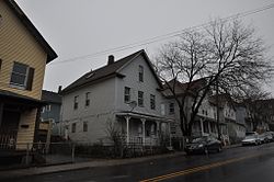
The Division Street Historic District encompasses one of the best-preserved 19th-century residential areas of Bridgeport, Connecticut. Now separated from downtown Bridgeport by the Connecticut Route 25 highway, the area includes a cross-section of 19th-century architectural styles, as well as a diversity of sophistication, from working-class accommodations to high-style Victorian mansions. The district was listed on the National Register of Historic Places in 1982.

The East Bridgeport Historic District encompasses one of the best-preserved 19th-century neighborhoods of Bridgeport, Connecticut. Bounded by Arctic Street, East Main Street, the railroad tracks, and the Pequonnock River, this area was a planned development of Bridgeport promoter P.T. Barnum and landowner William H. Noble. Its development prompted the significant growth of industry and economic activity east of the Pequonnock River. The district was listed on the National Register of Historic Places in 1979.

The Stratfield Historic District is a historic residential area on the west side of Bridgeport, Connecticut. In the late 19th and early 20th century, it was one of the highest-status and most fashionable neighborhoods in the city. At more than 100 acres (40 ha) in size, it is one of the largest assemblages of high-status residential architecture in the state. It was listed on the National Register of Historic Places in 1980.