Related Research Articles
Hyrum is a city in Cache County, Utah, United States. The population was 7,609 at the 2010 census, with an estimated population of 8,403 in 2018. It is included in the Logan, Utah–Idaho (partial) Metropolitan Statistical Area.

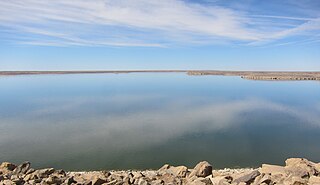
Cutler Reservoir is a reservoir located in Cache Valley in the U.S. state of Utah. It is an impoundment on the Bear River built for irrigation, flood control, and water supply.

Put-in-Bay Township is one of the twelve townships of Ottawa County, Ohio, United States. The 2000 census found 763 people in the township, 635 of whom lived in the unincorporated portions of the township.
The Little Bear River is a 36.4-mile-long (58.6 km) tributary of the Bear River in northern Utah in the United States. It rises in the mountains east of Brigham City, where three forks join at Avon, then flows north to Paradise. At Paradise it spills out into the broad flats of Cache Valley, passing north by Hyrum, where it is impounded by the Hyrum Reservoir, then meandering generally west by Wellsville. It meanders north again, receiving the Logan River in the Cutler Marsh, and eventually draining into the Bear River, although the junction is now submerged by the Cutler Reservoir.

Newton Dam is an earthen dam about a mile north of Newton, in Cache County, Utah, United States.
Porcupine Dam is a dam in East Canyon in Cache County, Utah, United States.
John Martin Reservoir is a reservoir on the Arkansas River in southeastern Colorado. Built and managed by the U.S. Army Corps of Engineers, it is used for flood control, irrigation, and recreation. John Martin Reservoir State Park lies on its shore.
Davenport Creek is a stream in Cache County, Utah, United States. It is also located within the Uinta-Wasatch-Cache National Forest and its mouth is about 2 miles (3.2 km) southeast of Avon. The creek rises in the Bear River Mountains and flows briefly southwest. It then turns northwest and runs in that direction for most of its course before emptying into the South Fork Little Bear River at a point immediately west of Utah State Route 162. The main tributaries of Davenport Creek are Pole Creek, Bald Head Creek, Smith Creek, and Fish Creek.
References
- ↑ U.S. Geological Survey Geographic Names Information System: The Island
- ↑ USGS 1:25,000 topographic map "Logan, UT", 1916, accessed via United States Geological Survey National Geospatial Program topoView website 2020-01-03
- ↑ "Cutler Reservoir and Marsh". National Audubon Society. Retrieved 2020-01-03.
Coordinates: 41°48′44″N111°56′14″W / 41.81222°N 111.93722°W