Related Research Articles

The Bay of Quinte is a long, narrow bay shaped like the letter "Z" on the northern shore of Lake Ontario in the province of Ontario, Canada. It is just west of the head of the Saint Lawrence River that drains the Great Lakes into the Gulf of Saint Lawrence. It is located about 200 kilometres (120 mi) east of Toronto and 350 kilometres (220 mi) west of Montreal.

A swamp is a forested wetland. Swamps are considered to be transition zones because both land and water play a role in creating this environment. Swamps vary in size and are located all around the world. The water of a swamp may be fresh water, brackish water, or seawater. Freshwater swamps form along large rivers or lakes where they are critically dependent upon rainwater and seasonal flooding to maintain natural water level fluctuations. Saltwater swamps are found along tropical and subtropical coastlines. Some swamps have hammocks, or dry-land protrusions, covered by aquatic vegetation, or vegetation that tolerates periodic inundation or soil saturation. The two main types of swamp are "true" or swamp forests and "transitional" or shrub swamps. In the boreal regions of Canada, the word swamp is colloquially used for what is more correctly termed a bog, fen, or muskeg. Some of the world's largest swamps are found along major rivers such as the Amazon, the Mississippi, and the Congo.

The Great Black Swamp was a glacially fed wetland in northwest Ohio, sections of lower Michigan, and extreme northeast Indiana, United States, that existed from the end of the Wisconsin glaciation until the late 19th century. Comprising extensive swamps and marshes, with some higher, drier ground interspersed, it occupied what was formerly the southwestern part of proglacial Lake Maumee, a holocene precursor to Lake Erie. The area was about 25 miles (40 km) wide and 100 miles (160 km) long, covering an estimated 1,500 square miles (4,000 km2). Gradually drained and settled in the second half of the 19th century, it is now highly productive farmland. However, this development has been detrimental to the ecosystem as a result of agricultural runoff. This runoff, in turn, has contributed to frequent toxic algal blooms in Lake Erie.

The Trent River is a river in southeastern Ontario which flows from Rice Lake to empty into the Bay of Quinte on Lake Ontario. This river is part of the Trent-Severn Waterway which leads to Georgian Bay. The river is 90 kilometres (56 mi) long. The Trent drains a large portion of south-central Ontario, including most of the Kawartha Lakes and their supplying watersheds.

Lake Scugog is an artificially flooded lake in Scugog, Regional Municipality of Durham and the unitary city of Kawartha Lakes in central Ontario, Canada. It lies between the communities of Port Perry and Lindsay. The lake has been raised and lowered several times over its history. Though not technically part of the Kawartha lakes due to its shallow depths, it is often geographically linked to them. Its sole outflow, the Scugog River, connects to Sturgeon Lake. Lake Scugog is in the Great Lakes Basin and forms part of the Trent–Severn Waterway.

The Pinsk Marshes, also known as the Pripet Marshes, the Polesie Marshes, and the Rokitno Marshes, are a vast natural region of wetlands along the forested basin of the Pripyat River and its tributaries from Brest to the west to Mogilev to the northeast and Kyiv to the southeast. It is one of the largest wetland areas of Europe. The city of Pinsk is one of the most important in the area.

Ansnorveldt is a hamlet located at the northeastern extent of King Township, in Ontario, Canada. It is located in the Holland Marsh, north of Highway 9. Whereas most of King township is in the Oak Ridges—Markham electoral district, Ansnorveldt and all other portions of King north of Highway 9 are part of the York—Simcoe electoral district, represented federally by Scot Davidson of the Conservative Party of Canada and provincially by Caroline Mulroney of the Progressive Conservative Party of Ontario.
Pottageville is an unincorporated community located in northeastern King Township, in Ontario, Canada. It is near Schomberg. It is named for one of its early settlers, Edward Pottage.
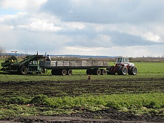
The Holland Marsh is a wetland and agricultural area in Ontario, Canada, about 50 kilometres (31 mi) north of Toronto. It lies entirely within the valley of the Holland River, stretching from the northern edge of the Oak Ridges Moraine near Schomberg to the river mouth at Cook's Bay, Lake Simcoe. In its entirety it comprises about 21,000 acres, with two distinct divisions. Historically it has simply been referred to as "the marsh".

The Okefenokee National Wildlife Refuge is a 402,000‑acre (1,627 km2) National Wildlife Refuge located in Charlton, Ware, and Clinch Counties of Georgia, and Baker County in Florida, United States. The refuge is administered from offices in Folkston, Georgia. The refuge was established in 1937 to protect a majority of the 438,000 acre (1,772 km2) Okefenokee Swamp. The name "Okefenokee" is a Native American word meaning "trembling earth."
Stirling-Rawdon is a township in the Canadian province of Ontario, located in Hastings County. It was formed on January 1, 1998, through the amalgamation of Rawdon Township with the Village of Stirling. Stirling was named the 2012 Kraft Hockeyville winner, after gaining more than 3.9 million votes.
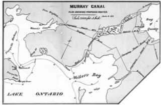
The Murray Canal is a canal in the municipalities of Quinte West and Brighton, Ontario, Canada, and runs from the western end of the Bay of Quinte to Presqu'ile Bay on Lake Ontario. It is approximately 8 kilometres (5 mi) in length and has maximum depth of 9 feet (2.7 m). The canal shortens the trip for boats wishing to access Lake Ontario from the central and western Bay of Quinte by avoiding having to go around the whole peninsula of Prince Edward County.
Seymour is a former incorporated township and now a geographic township located in Northumberland County, Ontario, Canada. It is currently part of the Municipality of Trent Hills.
Percy, Ontario was a former incorporated township and now a geographic township located in Northumberland County, Ontario, Canada. It is currently part of the Municipality of Trent Hills.
There are numerous natural areas in King, a township in Ontario, Canada. These areas are zones officially designated by the Government of Ontario that are within the township and exhibit provincially or regionally significant features representative of the region. The list of zones is defined and maintained by the provincial Ministry of Natural Resources Natural Heritage Information Centre.

Minesing Wetlands, previously known as Minesing Swamp, is a Ramsar boreal wetland in central Ontario, Canada stretching from the western periphery of Barrie to Georgian Bay. It was identified and classified through the International Biological Program. It is "the largest and best example of fen bog in southern Ontario", one of the "most diverse undisturbed wetland tracts in Canada" and is a provincially significant Area of Natural and Scientific Interest. The term minesing is of Ojibwe origin and means "island", referring to an island located within Lake Edenvale, which encompassed the present-day wetlands and surrounding areas.

The Big Black River is a river crossing the administrative region of Chaudière-Appalaches in Quebec and in Maine. From its source, in L'Islet RCM, Quebec, the river runs northeast and east across the Canada–United States border in Maine Township 14, Range 16, WELS, to the Saint John River in Northwest Aroostook T 15, R 13.

The Billabong Creek, a partly perennial stream of the Murray River catchment within the Murray-Darling basin, is located in the Riverina region of New South Wales, Australia.
The Conroy Marsh is a provincially significant wetland in Renfrew County, Ontario. Covering an area of 2,400 hectares, it was designated as a conservation reserve in 2003. It is also known as Conroy's Marsh or Conroys Marsh.
References
- Ontario Natural Heritage Information Centre [ dead link ]
- Quinte West Ontario- tourism, events, information
- Topographical Map, Dept. of Energy, Mines and Resources, Ottawa (published 1982)