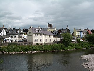
Brecon, archaically known as Brecknock, is a market town in Powys, mid Wales. In 1841, it had a population of 5,701. The population in 2001 was 7,901, increasing to 8,250 at the 2011 census. Historically it was the county town of Brecknockshire (Breconshire); although its role as such was eclipsed with the formation of the County of Powys, it remains an important local centre. Brecon is the third-largest town in Powys, after Newtown and Ystradgynlais. It lies north of the Brecon Beacons mountain range, but is just within the Brecon Beacons National Park.

Dorchester is the county town of Dorset, England. It is situated between Poole and Bridport on the A35 trunk route. A historic market town, Dorchester is on the banks of the River Frome to the south of the Dorset Downs and north of the South Dorset Ridgeway that separates the area from Weymouth, 7 miles (11 km) to the south. The civil parish includes the experimental community of Poundbury and the suburb of Fordington.

Until 1974, Montgomeryshire was an administrative county in mid Wales, later classed as one of the thirteen historic counties of Wales. It was named after its county town, Montgomery, which in turn was named after one of William the Conqueror's main counsellors, Roger de Montgomerie, who was the 1st Earl of Shrewsbury.

Until 1974, Radnorshire was an administrative county in mid Wales, later classed as one of the thirteen historic counties of Wales. It covered a sparsely populated area, and was bounded to the north by Montgomeryshire and Shropshire, to the east by Herefordshire, to the south by Brecknockshire and to the west by Cardiganshire.

Newtown is a town in Powys, Wales. It lies on the River Severn in the community of Newtown and Llanllwchaiarn, within the historic boundaries of Montgomeryshire. It was designated a new town in 1967 and saw population growth as firms settled, changing its market town character. Its 2001 population of 10,780 rose to 11,357 in the 2011 census, and rose again to 11,362 in the 2021 census.

Llanidloes is a town and community on the A470 and B4518 roads in Powys, within the historic county boundaries of Montgomeryshire, Wales. The population in 2011 was 2,929, of whom 15% could speak Welsh. It is the third largest settlement in Montgomeryshire, after Newtown and Welshpool.

Llandrindod Wells is a town and community in Powys, Wales. It serves as the seat of Powys County Council, and is therefore the administrative centre of Powys. The town was historically in Radnorshire.

Montgomery is a town and community in Powys, Wales. It is the traditional county town of the historic county of Montgomeryshire to which it gives its name, and it is within the Welsh Marches border area. The town centre lies about 1 mile (1.6 km) west of the England–Wales border. Montgomery Castle was started in 1223 and its parish church in 1227. Other locations in the town include The Old Bell Museum, the Offa's Dyke Path, the Robber's Grave and the town wall. The large Iron Age hill fort of Ffridd Faldwyn is sited northwest of the town and west of the Castle.

Montgomeryshire was a constituency in Wales represented in the House of Commons of the UK Parliament.
A county hall or shire hall is a common name given to a building that houses the seat of local government for a county.

Churchstoke or Church Stoke is a village, community and electoral ward in Montgomeryshire, Powys, Wales. Located in the southeast of the Vale of Montgomery, it is overlooked by Todleth Hill, Roundton Hill and Corndon Hill. The rivers Caebitra and Camlad have their confluence just outside the village. The nearest town is Montgomery. In the 2011 census the village had a population of 708.
Dinas Powys is a small town and community in the Vale of Glamorgan, South Wales. Its name means "fort of the provincial place" and refers to the Iron Age hillfort which overlooks the village. Dinas Powys is 5.6 miles (9.0 km) south-west of the centre of Cardiff and is situated on the A4055 road from Cardiff to Barry, making it a popular dormitory village for city commuters. It neighbours the larger town of Penarth.

Llanfyllin is a market town and community in Powys, Wales. The town population in 2021 was 1,586 and the town's name means church or parish (llan) of St Myllin. The community includes the settlements of Bodfach, Ty Crwyn, Abernaint and several farms.

Montgomery Castle is a stone castle looking over the town of Montgomery in Powys, Mid Wales. It is one of many Norman castles on the border between Wales and England.

Hen Domen Welsh, meaning "old mound", is the site of a medieval timber motte-and-bailey castle in Powys, Wales. It is the site of the original Montgomery Castle, and was built by Roger de Montgomery in 1070. From 1105 the castle was the home of the de Boulers (Bowdler) family, and it is from Baldwin de Boulers that Montgomery gets its Welsh name, Trefaldwyn "The Town of Baldwin". When the castle was rebuilt in stone (1223–1234), it was decided to rebuild it on a rocky promontory a mile to the south-east – the location of the current town of Montgomery, Powys. The Hen Domen site has been extensively excavated.

Llanfechain is a village and community in Powys, Wales, on the B4393 road between Llanfyllin and Llansantffraid-ym-Mechain. Historically it belonged to Montgomeryshire. The River Cain runs through. The population of 465 at the 2011 Census was estimated at 476 in 2019.
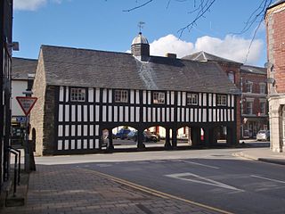
The Old Market Hall is the oldest timber-framed market hall in Llanidloes, Wales, dating to the early 17th century. Until well into the 20th century a weekly market was held on the open cobbled ground floor. Over the years the large and well-lit upper floor room has been used as a wool and flannel market, law court, preachers' hall, flannel store, working men's institute and museum.
Newtown and Llanllwchaiarn is a local government community in mid Powys, Wales. It includes the town of Newtown and the small neighbouring village of Llanllwchaiarn. At the time of the 2011 census the population of the community was 11,357. The community council is called Newtown and Llanllwchaiarn Town Council, often abbreviated to Newtown Town Council.

The Shire Hall is a municipal structure in Broad Street, Presteigne, Powys, Wales. The building incorporates a well-preserved courtroom and a museum known as "the Judge's Lodging". Once the judicial centre for Radnorshire, is a Grade II* listed building.

Montgomery Town Hall is a municipal building in Broad Street, Montgomery, Wales. It served as the meeting place of Montgomery Borough Council and is a Grade II* listed building.

