The Priory, Burwood

Last updated

The Priory and grounds
The Priory-3a.jpg
The Priory, c1987
Location213 Burwood Road, Burwood, Municipality of Burwood, New South Wales, Australia
Coordinates 33°53′00″S151°06′07″E / 33.8834°S 151.1019°E / -33.8834; 151.1019
Built1877
Official namePriory and Grounds; The Priory & Grounds
TypeState heritage (complex / group)
Designated2 April 1999
Reference no.287
TypeMansion
CategoryResidential buildings (private)
Location map Australia Sydney.png
Red pog.svg
Location of The Priory and grounds in Sydney

The Priory is a heritage-listed residence at 213 Burwood Road, in the Sydney suburb of Burwood in the Municipality of Burwood local government area of New South Wales, Australia. It was built in 1877. The Priory and its grounds was added to the New South Wales State Heritage Register on 2 April 1999. [1]

Contents

History

Burwood

Parramatta Road was first created in 1791, a vital land (rather than water) artery between Sydney Cove and Rose Hill's settlement and crops. Liverpool Road opened in 1814 as Governor Macquarie's Great South Road. Its winding route reflects pre-existing land grant boundaries and topography. To Burwood's north over Parramatta Road was Longbottom Government Farm, staffed by convicts. This grew to over 280 hectares (700 acres) on heavily timbered flat, sloping to swamps on Hen and Chicken Bay. Commissioner Bigge recorded how valuable timber (ironbark) was cut and sawn on the spot, conveyed to Sydney in boats by the river. "Charcoal for the forges and foundries is likewise prepared here" he noted. [1]

Two grants, over Burwood's clay soil, were important to the area's development: Captain Thomas Rowley's Burwood Farm estate and William Faithful's 400-hectare (1,000-acre) grant to its south in Enfield covered most of modern Burwood. Rowley, adjutant of the NSW Corps, named it after the farm he'd lived on in Cornwall. 1799 and subsequent grants brought it to 300 hectares (750 acres) but he continued to live at Kingston Farm in Newtown until his death in 1806. He'd bought some of the first Spanish merinos brought from the Cape Colony in 1797, others being sold to Macarthur, Marsden & Cox. The southern boundary of his farm was approximately today's Woodside Avenue and Fitzroy Street. [1]

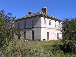
Under Rowley's will the estate passed to his three underage children. Executors Dr Harris and Major Johnstone were both involved in the 1808 Bligh rebellion and returned to England for the court martial, so Governor Macquarie appointed Thomas Moore as guardian and executor. In 1812 he wrongfully auctioned the estate. It was bought by Sydney businessman Alexander Riley. He's believed to have built Burwood Villa in 1814 (perhaps on older (1797) foundations of Rowley's shepherd's cottage) and lived here until departing for England in 1817. 200 hectares (500 acres) had been cleared for pasture. In 1824 Joseph Lycett described the estate in Views of Australia, as "a garden of 4 acres in full cultivation, containing upwards of three hundred Trees, bearing the following choice fruits, viz. The Orange, Citron, Lemon, Pomegranate, Loquat, Guava, Peaches, Nectarines, Apricots, Apples, Pears, the Cherry, Plums, Figs, Chestnuts, Almonds, Medlars, Quinces; with abundance of Raspberries, Strawberries, and the finest Melons. &c;". [1]

Until the 1830s Burwood consisted of a few inns along the highways and two or three huge, undeveloped estates. Within the next 20 years these began to break up, attracting settlers and encouraging the growth of nascent villages at Burwood and Enfield. Riley died in 1833 and Rowley's children, now of age, started legal proceedings and regained possession of the 750-acre estate. It was divided between Thomas jnr., John, John Lucas and Henry Biggs. Almost at once they subdivided into lots of 1.6–8.1 hectares (4–20 acres) for country homes and small farms. In 1834 the Burwood estate was held by John Lucas, husband of Thomas's daughter Mary Rowley), who divided 46 hectares (113 acres) of his 86 hectares (213 acres) into small allotments for sale. Streets such as Webb, Lucas Road, Wentworth Road and Strathfield's The Boulevarde reflect the boundaries of these subdivisions/estates. [1]

To the south (including the land that later become the Appian Way) was William Faithful's grant of 400 hectares (1,000 acres) (1808) at "Liberty Plains". Faithful was a private in the NSW Corps: discharged in 1799 he became Captain Foveaux's farm manager, and this connection got him the grant. Apart from 6.1 hectares (15 acres) of Sarah Nelson's on Malvern Hill (Croydon), Faithful's Farm extended from Rowley's farm to Cooks River and west to Punchbowl Road. The government retained a right to build a road through it (doing so in 1815: Liverpool Road or the Great South Road, now the Hume Highway), and to cut "such timber as may be deemed fit for naval purposes" - the area was thick with tall ironbark. Faithful exchanged it in 1815. Alexander Riley bought his 81 hectares (200 acres) north of the new road incorporating it into his Burwood estate. This was jointly owned by the Rowley family after 1833 and had no streets across it, only a few tracks. [1]

Despite opening up of the Rowley estate there was little settlement in Burwood between the two highways before 1860. Sydney Railway Company opened the first railway line to Parramatta in 1855. Burwood "station" (just west of Ashfield station, one of the first stations) was a wooden platform near a level crossing over the grassy track that was Neich's Lane (later Burwood Road). This was beside "the newly laid out township of Cheltenham". Speedy transport meant subdivision and consolidation followed, filling out the area. Burwood's biggest growth spurt was between 1874 & 1900 (Burwood's population was, respectively: 1200–7400, an increase not matched since. 1835 maps show this as the only track between Parramatta / Liverpool Roads in Burwood. [1]

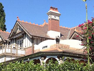
Burwood's first public school was established c.1838. In 1843 land on Burwood Road was granted to the Anglican Church for a school. St. Mary's Catholic Church opened in 1846, a Presbyterian Church in 1857 and St. Paul's Anglican in 1871. Mansions of the 1870s such as The Priory were built here due to a firm belief in its health-giving climate, compared to the smog and crowding of the city suburbs. They were built as quasi-ancestral estates, perhaps in blissful ignorance of how quickly suburbs can evolve. Living was primitive: no street lighting (until 1883), home lighting by candle or lamp (oil, kerosene after 1860), no gas (until 1882), no piped water (until 1886), home wells/tanks, few bathrooms, no indoor toilets, with pans (from 1880) replacing outdoor cess pits. [1]

The 1880s was the era of the debates that led to Australia's fractious states combining into a single Federation, declared at Sydney's Centennial Park, in 1901. Skilled tradesmen and materials were plentiful and comparatively cheap, and combined with the improvement in building techniques associated with cavity walls, damp-courses and terracotta tiled roofs, provided the means for an era of intense building activity. Unlike the Victorian era's large commercial and Government building, the main thrust of the Federation era was constructing new suburbs around Sydney harbour with shops for the middle classes. [1]

Between 1889 and 1918 Australia's population swelled from three to five million triggering an urgent need for housing. Suburban spread was greatly assisted by expansion of the public transport system of trams, ferries and trams, which formed a well-integrated pre-car transport system. [1] [2] Rapid suburban growth brought increased interest in town planning and the British concept (Ebenezer Howard's 'Garden City') of the Garden Suburb, spurred on by the Federal Capital Competition of 1912. 1913's arrival from North America of winners, Walter Burley & Marion Mahony Griffin, saw formation of the Town Planning Association of NSW, with architect John Sulman as president. Founding members Sulman and J. P. Fitzgerald were among witnesses at the 1900 Royal Commission into the Improvement of the City of Sydney and suburbs. This made the first attempt at a comprehensive review of Sydney's problems, gathering many reform ideas. It recognised the relationship between planning and local government and advocated introduction of a town planning bill along the lines of John Burns' 1900 English Bill. Some recommendations, such as introducing building regulations for the whole metropolitan area "to prevent the straggling of suburbs and to ensure development along harmonious lines" went into 1919's Local Government Act. [1]

The "Garden Suburb" came to mean a suburb with special areas zoned for different uses, e.g.: residential and commercial; an absence of attached terraces with free-standing houses, wide tree-lined streets, "nature strips" on footpaths, parks reserves and gardens. Much-derided rear lanes and rights-of-way became redundant with sewerage and the provision of side access between houses. Verandas and bay windows were means of integrating house & garden. [1]

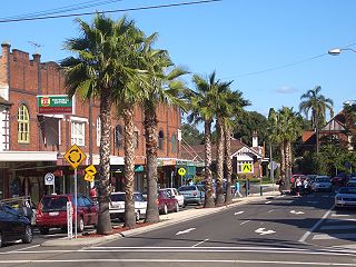
Tree-lined streets such as Burwood Road, The Appian Way or The Boulevard in Strathfield were in marked contrast to most development in Australian cities of the late 19th century. [1] [2]

The Priory

The Priory was built by grazier Mowbray Forrest, in 1877 on land purchased from C. H. Humphrey. Forrest was a prominent citizen and trustee of the Burwood School of Arts. [3] [1]

It is representative of the mansions that were built to house the wealthy families of the late nineteenth century, dating from 1877 and being one of the first mansions on Burwood Road, with an expansive garden. It is a reminder that Burwood was one of Sydney's fashionable suburbs for the well to do. [4] [1]

Description

The Priory is representative of mansions that were built to house the wealthy families of the late nineteenth century. It is a two-storey Victorian mansion dating from 1877, one of the first on Burwood Road. It features a three-storey elaborately decorated tower, a two-storey verandah with cast iron balustrades and an attractive bay window. It has an expansive garden. [1] [5]

An excellent example of the great Victorian mansions and a reminder that Burwood was one of Sydney's fashionable suburbs for the well to do. The house has fine external applied detailing and has retained its landscaping. It is a good example of its period and a rare survival in condition and setting. Two storey Victorian mansion with three storey tower. Built of brick, cement and stone foundations. Walls are cemented and painted, the tower is richly ornamented. Front projecting wing and two storey decorative cast iron verandahs. Front projecting wing has decorated bay window on ground floor and forms open verandah to first floor with edging of decorative iron well landscaped gardens, lawns and driveway. [6] [1]

It has an expansive garden - a rare survivor and evidence of Burwood's onetime prominence among Sydney's fashionable suburbs. The mansion is well set back from Burwood Road with a semi-circular sweep of carriage loop in gravel, edged with recently replanted box hedges (Buxus sempervirens). To the mansion's north-west and rear is a fenced tennis court. [1]

The front garden's detailed plantings have recently been reinstated (gravel drive, box hedges, cast iron fountain). A number of mature large trees line the front iron fence facing Burwood Road between the two drive entry gates: a Queensland /macadamia nut ( Macadamia integrifolia ), lemon-scented gums ( Corymbia citriodora ), Port Jackson figs ( Ficus rubiginosa ), a Canary Island date palm ( Phoenix canariensis ), camphor laurel ( Cinnamomum camphora ), brush box ( Lophostemon confertus ) and another species of fig (Ficus ?microphylla). To the south on Minna Avenue are more mature figs which indicate the extent of The Priory's land prior to subdivision on this side. [7] [1]

Modifications and dates

The front garden's detailed plantings have recently[ when? ] been reinstated (gravel drive, box hedges, cast iron fountain). [8] [1]

Heritage listing

The Priory and Grounds was listed on the New South Wales State Heritage Register on 2 April 1999. [1]

See also

Related Research Articles

<span class="mw-page-title-main">Croydon, New South Wales</span> Suburb of Sydney, New South Wales, Australia

Croydon is a suburb in the Inner West of Sydney, in the state of New South Wales, Australia. It is located 9 kilometres (5.6 mi) west of the Sydney central business district. Croydon is split between the two local government areas of Municipality of Burwood and the Inner West Council.

<span class="mw-page-title-main">Burwood, New South Wales</span> Suburb of Sydney, New South Wales, Australia

Burwood is a suburb in the Inner West of Sydney, in the state of New South Wales, Australia. It is 10 kilometres (6.2 mi) west of the Sydney central business district and is the administrative centre for the local government area of Municipality of Burwood.

<span class="mw-page-title-main">Experiment Farm Cottage</span> Historic site in New South Wales, Australia

Experiment Farm Cottage is a heritage-listed former farm and residence and now house museum at 9 Ruse Street, Harris Park, City of Parramatta, Sydney, Australia. It is one of Australia's oldest standing residences, being built in c.1834. It is located at the site of Experiment Farm, Australia's first European farmstead, which was itself created by Australia's first land grant. It was added to the New South Wales State Heritage Register on 2 April 1999.

<span class="mw-page-title-main">Burwood railway station, Sydney</span> Railway station in Sydney, New South Wales, Australia

Burwood railway station is a heritage-listed railway station located on the Main Suburban line in the Sydney suburb of Burwood in the Municipality of Burwood local government area of New South Wales, Australia. The station is served by Sydney Trains T9 Northern line and T2 Inner West & Leppington line services.

<span class="mw-page-title-main">Elizabeth Farm</span> Rural estate in New South Wales, Australia

Elizabeth Farm is a historic estate located at 70 Alice Street, Rosehill, a suburb of Sydney, New South Wales, Australia. Elizabeth Farm was the family home of wool pioneers John and Elizabeth Macarthur. The estate was commenced in 1793 on a slight hill overlooking the upper reaches of Parramatta River, 23 kilometres (14 mi) west of Sydney Cove. The Burramattagal clan of the Dharug people are the traditional custodians of the area; their presence is recalled in the name Parramatta.

<span class="mw-page-title-main">Vaucluse House</span> Heritage house in Sydney, Australia

Vaucluse House is a heritage-listed residence, colonial farm and country estate and now tourist attraction, house museum and public park, formerly the home of statesman William Charles Wentworth and his family. It is located at 69a Wentworth Road, Vaucluse in the Municipality of Woollahra local government area of New South Wales, Australia. Completed between 1803 and 1839 in the Gothic Revival style, its design was attributed to W. C. Wentworth and built by Sir Henry Browne Hayes and W. C. Wentworth. The property is owned by the Historic Houses Trust of New South Wales, an agency of the Government of New South Wales. The site was added to the New South Wales State Heritage Register on 2 April 1999.

<span class="mw-page-title-main">Newington House</span> House in New South Wales, Australia

Newington House is a historic house in Silverwater, New South Wales, Australia and is located 20 kilometres (12 mi) west of the Sydney central business district, in the local government area of the City of Parramatta. The house and chapel are situated on the southern bank of the Parramatta River and are now enclosed by the Silverwater Correctional Centre. With Elizabeth Bay House and Camden Park, it is considered to be one of the three great houses of the County of Cumberland.

<span class="mw-page-title-main">The Hermitage, Denistone</span> Historic site in New South Wales, Australia

The Hermitage is a heritage-listed residence and former research institute and government office located at 1-13 Pennant Avenue, Denistone in the City of Ryde local government area of New South Wales, Australia. It was possibly designed by architect John Bibb and built from 1838 to 1842 in the Australian colonial Victorian era style. It is also known as The Hermitage and Garden. The property is privately owned. It was added to the New South Wales State Heritage Register on 2 April 1999.

<span class="mw-page-title-main">Rouse Hill House</span> Homestead complex in New South Wales, Australia

Rouse Hill Estate is a heritage-listed homestead and estate off Windsor Road, Rouse Hill, City of Blacktown, New South Wales, Australia. Rouse Hill House and farm was the family home of Richard Rouse, the Colonial Superintendent of Public Works and Convicts at Parramatta.

<span class="mw-page-title-main">Yasmar</span> Historic site in New South Wales, Australia

Yasmar is a heritage-listed house at 185 Parramatta Road, Haberfield, Inner West Council, Sydney, New South Wales, Australia. It has variously served as a private home, Sunday school, children's court and juvenile remand and detention centre, and is now used by community groups and as a correctional services training facility. It was designed by John Bibb and built from 1856 to 1858. The surrounding site has also been known as Yasmar Hostel, Yasmar Detention Centre, Yasmar Child Welfare Home, Ashfield Remand Home, Yasmar Shelter and the Yasmar Juvenile Justice Centre. The property is owned by Land and Property Management Authority (LPMA). It was added to the New South Wales State Heritage Register on 18 February 2000.

<span class="mw-page-title-main">Bungarribee Homestead Site</span> Historic site in New South Wales, Australia

The Bungarribee Homestead Site is a heritage-listed archaeological site at the location of the former Bungarribee Homestead. The site is located at Doonside Road, Doonside, City of Blacktown, Sydney New South Wales, Australia. It was added to the New South Wales State Heritage Register on 8 December 2000.

<span class="mw-page-title-main">Essington, Westmead</span> Historic site in New South Wales, Australia

Essington is a heritage-listed former gentleman's residence and farm estate and now independent school located at 2, 4, 6, and 8 Bridge Road, Westmead in the Cumberland Council local government area of New South Wales, Australia. It was built from 1860 to 1890. It is also known as Essington Christian Centre; Westmead Christian Grammar School. The property is owned by Church of the Foursquare Gospel. It was added to the New South Wales State Heritage Register on 2 April 1999.

<span class="mw-page-title-main">Riverview House, West Ryde</span> Historic site in New South Wales, Australia

Riverview House is a heritage-listed former orchard and now residence at 135 Marsden Road, West Ryde in the City of Ryde local government area of New South Wales, Australia. It was built from 1860 to 1878 by George Spurway. The property is privately owned. It was added to the New South Wales State Heritage Register on 2 April 1999.

<span class="mw-page-title-main">Hooper Cottage</span> Historic site in New South Wales, Australia

Hooper Cottage is a heritage-listed residence at 17 Gilderthorpe Avenue in the Sydney suburb of Randwick in the City of Randwick local government area of New South Wales, Australia. It was built from 1847 to 1848. It was added to the New South Wales State Heritage Register on 2 April 1999.

<span class="mw-page-title-main">Burwood Post Office</span> Historic site in New South Wales, Australia

The Burwood Post Office is a heritage-listed former Aboriginal land, farm and former post office and now retail building located at 168a Burwood Road in the Sydney suburb of Burwood in the Municipality of Burwood local government area of New South Wales, Australia. It was designed by Walter Liberty Vernon and George Oakeshott and built by New South Wales Works Branch. It is also known as Burwood Post Office (former). It was added to the New South Wales State Heritage Register on 18 May 2001.

<span class="mw-page-title-main">St. Cloud, Burwood</span> Historic site in New South Wales, Australia

St. Cloud is a heritage-listed mansion located at 223 Burwood Road in the Sydney suburb of Burwood in the Municipality of Burwood local government area of New South Wales, Australia. It was built by George Hoskins. It is also known as St. Cloud and Site and St Cloud and site. It was added to the New South Wales State Heritage Register on 2 April 1999.

<span class="mw-page-title-main">St Paul's Anglican Church, Burwood</span> Church in New South Wales, Australia

St Paul's Anglican Church and Pipe Organ is a heritage-listed Anglican church building and pipe organ located at 205 Burwood Road in the Sydney suburb of Burwood in the Municipality of Burwood local government area of New South Wales, Australia. The church was designed by Edmund Blacket and the organ was designed by William Davidson, with some consultation from Montague Younger. The church and organ were built from 1889 to 1891. The church is also known as St. Paul's Anglican Church and Pipe Organ, St Paul's Anglican Church and Davidson Pipe Organ. The property is owned by Anglican Church Property Trust. It was added to the New South Wales State Heritage Register on 2 April 1999.

<span class="mw-page-title-main">Lynton, Burwood</span> Historic site in New South Wales, Australia

Lynton is a heritage-listed residence located at 4 Clarence Street in the Sydney suburb of Burwood in the Municipality of Burwood local government area of New South Wales, Australia. It was designed by Stanley Rickard and built from 1906. It was added to the New South Wales State Heritage Register on 2 April 1999.

<span class="mw-page-title-main">Raby, Catherine Field</span> Historic site in New South Wales, Australia

Raby is a heritage-listed former sheep farm and cattle farm and now private residence located at 1025 Camden Valley Way in the south-western Sydney suburb of Catherine Field in the Camden Council local government area of New South Wales, Australia. It was designed and built from 1820 to 1834; and was added to the New South Wales State Heritage Register on 1 March 2010.

<i>Varroville</i> (homestead) Historic site in New South Wales, Australia

Varroville is a heritage-listed former farm and now rural residence at 196 St Andrews Road, Varroville, New South Wales, Australia. It was designed by Weaver and Kemp and built from 1810 to 1859. It is also known as Varro Ville and Varra Ville. The property is privately owned. It was added to the New South Wales State Heritage Register on 2 April 1999.

References

  1. 1 2 3 4 5 6 7 8 9 10 11 12 13 14 15 16 17 18 19 20 21 "Priory and Grounds". New South Wales State Heritage Register . Department of Planning & Environment. H00287. Retrieved 1 June 2018. CC BY icon.svg Text is licensed by State of New South Wales (Department of Planning and Environment) under CC-BY 4.0 licence .
  2. 1 2 Fraser, Hugh, in Heritage Council of NSW, 1981-4, amended and added to by Stuart Read, 17/5/2008 with excerpts from Eric Dunlop (1975).
  3. Dunlop, 1974
  4. LEP, modified Read, S., 17/5/2008
  5. LEP
  6. RNE, 1982
  7. Read, Stuart, pers.comm., 17/5/2008
  8. Read, S., pers.comm., 17/5/2008

Bibliography

Attribution

CC BY icon-80x15.png This Wikipedia article was originally based on Priory and Grounds , entry number 00287 in the New South Wales State Heritage Register published by the State of New South Wales (Department of Planning and Environment) 2018 under CC-BY 4.0 licence , accessed on {{{accessdate}}}.

Commons-logo.svg Media related to The Priory, Burwood at Wikimedia Commons