
The Sword is a public house at 43 and 45 Westgate Street, Gloucester, England, that is a grade II listed building with Historic England. [1] It was formerly known as The Union and Molly's Bar. [2] [3] [4]
The Sword is a public house at 43 and 45 Westgate Street, Gloucester, England, that is a grade II listed building with Historic England. [1] It was formerly known as The Union and Molly's Bar. [2] [3] [4]
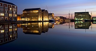
Gloucester is a cathedral city and the county town of Gloucestershire in the South West of England. Gloucester lies on the River Severn, between the Cotswolds to the east and the Forest of Dean to the west; it is sited 19 miles (31 km) from Monmouth, 33 miles (53 km) from Bristol, and 17 miles (27 km) east of the border with Wales. Gloucester has a population of around 132,000, including suburban areas. It is a port, linked via the Gloucester and Sharpness Canal to the Severn Estuary.

Frampton Mansell is a small English village 5 miles east-south-east of Stroud, Gloucestershire, in the parish of Sapperton. It lies off the A419 road between Stroud and Cirencester. It has a prominent mid-19th century, Grade II listed church with a set of five original stained-glass windows.

The New Inn, 16 Northgate Street, Gloucester, England, is a timber framed building used as a public house, hotel and restaurant. It is the most complete surviving example of a medieval courtyard inn with galleries in Britain, and is a Grade I listed building. The announcement of Lady Jane Grey's succession to the English throne was made from the Inn gallery in 1553.

The Westgate area of Gloucester is centred on Westgate Street, one of the four main streets of Gloucester and one of the oldest parts of the city. The population of the Westgate ward in Gloucester was 6,687 at the time of the 2011 Census.

The Folk of Gloucester is a museum which is housed in two of the oldest buildings in the city of Gloucester, a Tudor merchant's house and a 17th-century town house. The museum, at 99–103 Westgate Street, is devoted to the social history of Gloucestershire.

Womanby Street is one of the oldest streets in Cardiff, the capital of Wales. Tracing its name back to origins within the Norse language, its original purpose was to link Cardiff Castle to its quay. In this way it became a trade hub and settling point for those incomers who made the city their home. Throughout its history the street has had several pubs, and today has several bars and clubs.

The Square and Compass is a Grade II listed public house in Worth Matravers, Dorset. Built in the 18th century as a pair of cottages before becoming a public house, the Square and Compass got its name in 1830 from a landlord who had been a stonemason. The building includes a museum of fossils and other local artefacts and the pub is one of only five nationally that has been included in every edition of CAMRA's Good Beer Guide since 1974.

The Five Mile House is a historic former pub located on Old Gloucester Road in Duntisbourne Abbots, Gloucestershire, England. Built in the 17th century, it is a grade II listed building.

There are no records to state that the house was built in the 1200's. It was in fact built in the 1400's.

The Lower George Hotel, now the Lower George Inn, is a grade II listed building at 121 Westgate Street, Gloucester.
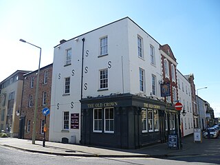
The Old Crown Inn was a grade II listed pub house at 81 and 83 Westgate Street, Gloucester.

The Fountain Inn is a grade II listed pub at 53 Westgate Street, Gloucester, England. It is mentioned in an Abbey Rental document of 1455. Some of the building is from the late 16th century but it was mostly rebuilt in the late 17th century, altered in the 18th century, and remodelled around 1900.
The Westgate Galleria are grade II listed almshouses in Westgate Street, Gloucester, now used as a small shopping centre. The building dates from 1787-90 when it was built by William Price for the City of Gloucester on the former site of St Bartholomew's Hospital which had been founded in the early 12th century.

The Old Spot Inn is a pub in Dursley, Gloucestershire, England.

66 Westgate Street is a grade II* listed building in Gloucester, UK. It has been listed by Historic England under the Planning Act 1990.

The Fleece Hotel, Westgate Street, Gloucester is a timber framed building dating from the 15th century, which incorporated a 12th-century stone undercroft. The building is part grade I and part grade II listed with Historic England.

Norfolk Buildings is a terrace of grade II listed houses at 73-91 Bristol Road, Gloucester, on the east side between Theresa Street and Alma Place.

Southgate Street is one of the ancient streets in the City of Gloucester, so named because its southern end was originally the location of the south gate in the city's walls. The part beyond the gate as far as Severn Street was sometimes known as Lower Southgate Street. It runs from the crossroads of Northgate, Eastgate, Southgate, and Westgate Streets in the north to Bristol Road in the south.

Northgate Street is a street in the City of Gloucester, so named because its northern end was originally the location of the north gate in the city's walls.

Eastgate Street is one of the ancient streets in Gloucester, so named because its eastern end was originally the location of the east gate in the city's walls. The part beyond the gate as far as GL1 leisure Centre was part of Barton Street It runs from the crossroads of Northgate, Eastgate, Southgate and Westgate Streets in the West to Barton Street in the East.
51°51′58″N2°14′51″W / 51.86612°N 2.24748°W
Buildings and structures in Gloucester | |||||||||||
|---|---|---|---|---|---|---|---|---|---|---|---|
| Religious |
| ||||||||||
| Civic | |||||||||||
| Hospitals |
| ||||||||||
| Transportation |
| ||||||||||
| Education |
| ||||||||||
| Houses |
| ||||||||||
| Shopping complexes | |||||||||||
| Sports venues |
| ||||||||||
| Libraries | |||||||||||
| Hotels |
| ||||||||||
| Banks |
| ||||||||||
| Pubs | |||||||||||
| Art and theatres |
| ||||||||||
| Museums | |||||||||||
| Priories/friaries/abbeys |
| ||||||||||
| Gatehouses | |||||||||||
| Former castles | |||||||||||
| Other | |||||||||||
| Lists | |||||||||||
| | This article about a Gloucestershire building or structure is a stub. You can help Wikipedia by expanding it. |