In architecture, a folly is a building constructed primarily for decoration, but suggesting through its appearance some other purpose, or of such extravagant appearance that it transcends the range of usual garden buildings.

The Irish Famine of 1740–1741 in the Kingdom of Ireland, is estimated to have killed between 13% and 20% of the 1740 population of 2.4 million people, which was a proportionately greater loss than during the Great Famine of 1845–1852.

The Irish Georgian Society is an architectural heritage and preservation organisation which promotes and aims to encourage an interest in the conservation of distinguished examples of architecture and the allied arts of all periods across Ireland, and records and publishes relevant material. The aims of this membership organisation are pursued by documenting, education, fundraising, grant issuance, planning process participation, lobbying, and member activities; in its first decades, it also conducted considerable hands-on restoration activities.
Celbridge is a town and townland on the River Liffey in County Kildare, Ireland. It is 23 km (14 mi) west of Dublin. Both a local centre and a commuter town within the Greater Dublin Area, it is located at the intersection of the R403 and R405 regional roads. As of the 2022 census, Celbridge was the third largest town in County Kildare by population, with 20,601 residents.

Richard Cassels, also known as Richard Castle, was an architect who ranks with Edward Lovett Pearce as one of the greatest architects working in Ireland in the 18th century. Cassels was born in 1690 in Kassel, Germany. Although German, his family were of French origin and descended from the French-Netherlandish 'Du Ry' family, famous for the many architects among their number. A cousin Simon Louis du Ry designed Schloss Wilhelmshöhe in Kassel.

A dovecote or dovecot, doocot (Scots) or columbarium is a structure intended to house pigeons or doves. Dovecotes may be free-standing structures in a variety of shapes, or built into the end of a house or barn. They generally contain pigeonholes for the birds to nest. Pigeons and doves were an important food source historically in the Middle East and Europe and were kept for their eggs and dung.

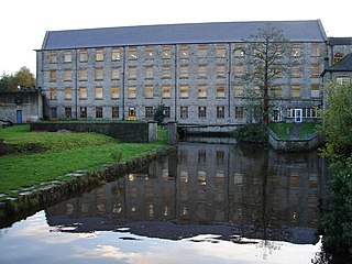
Castletown House, Celbridge, County Kildare, Ireland, is a Palladian country house built in 1722 for William Conolly, the Speaker of the Irish House of Commons. It formed the centrepiece of an 800-acre (320 ha) estate. The estate was sold in 1965, and later sub-divided. The house and a core demesne of 120 acres were bought by a group of people looking to preserve them, and became the first major project of the Irish Georgian Society; they were later transferred to a dedicated charitable foundation, and ultimately to State ownership. Most of the wider estate remaining was divided between State forestry company, Coillte, and developers, and parts were built on, notably the former orchard and walled garden. In September 2023, the main access road and car parking became the subject of access issues and protests.
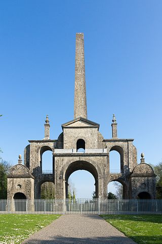
The Conolly Folly, a.k.a. The Obelisk, is an obelisk structure located between Celbridge, Leixlip and Maynooth in County Kildare, Ireland. It was built in the mid-18th century by the Conolly family, then owners of the Castletown Estate. It was restored in the mid-20th century by the Irish Georgian Society, and is now a national monument in state care.

The Leixlip Spa is an archaeological and hydrogeological complex at Louisa Bridge, Leixlip, near Dublin, Ireland, situated close to the Royal Canal. It was a popular health spa in the late 18th and early 19th century. The site is known to contain a warm mineralised spring and a cold spring originating from different sources. The archaeological structures comprise a hexagonal spring well and a Romanesque bath. The warm spring was uncovered in 1794 during the construction of the Royal Canal. The mineral spring, marsh and seepage areas at Louisa Bridge are included in the Rye Water Valley / Carton Special Area of Conservation
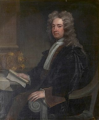
William Conolly, also known as Speaker Conolly, was an Irish Whig politician, Commissioner of Revenue, lawyer and landowner. He was an influential figure in Irish politics, serving as Speaker of the Irish House of Commons between 1715 and his death.
Desmond Walter Guinness was an Anglo-Irish author of Georgian art and architecture, a conservationist and the co-founder of the Irish Georgian Society. He was the second son of the author and brewer Bryan Guinness, 2nd Baron Moyne, and his then wife Diana Mitford.
Events from the year 1740 in Ireland.

Montpelier Hill is a 383-metre hill in County Dublin, Ireland. It is topped by the Hell Fire Club, the popular name given to the ruined building. This building – an occasional summer residence built in around 1725 by William Conolly – was originally called Mount Pelier and since its construction the hill has also gone by the same name. The building and hill were respectively known locally as 'The Brass Castle' and 'Bevan's Hill', but the original Irish name of the hill is no longer known although the historian and archaeologist Patrick Healy has suggested that the hill is the place known as Suide Uí Ceallaig or Suidi Celi in the Crede Mihi, the twelfth-century diocesan register book of the Archbishops of Dublin.
Arthur Price was Church of Ireland Archbishop of Cashel from 1744 until his death. Previously he had been Church of Ireland Bishop of Clonfert (1724–1730), Ferns and Leighlin (1730–1734) and Meath (1734–1744).
Larchill is a ferme ornée, and the site of multiple follies, in the townland of Phepotstown near Kilcock, County Kildare, Ireland. According to its owners, it is the "only surviving, near complete, garden of its type in Europe". The main component of Larchill Demesne, that was created in the mid-18th century, and restored in the mid-1990s.

Leixlip is a town in north-east County Kildare, Ireland. Its location on the confluence of the River Liffey and the Rye Water has marked it as a frontier town historically: on the border between the ancient kingdoms of Leinster and Brega, as an outpost of The Pale, and on Kildare's border with County Dublin. Leixlip was also a civil parish in the ancient barony of Salt North.

William James Conolly was an Irish landowner and Whig politician who sat in the Irish House of Commons from 1727 to 1754 and in the British House of Commons from 1734 to 1754.

George Byng of Wrotham Park in Middlesex, was a British politician who sat in the House of Commons from 1768 to 1784.
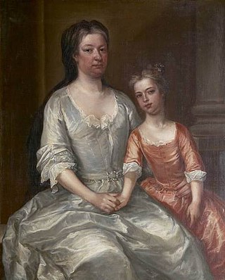
Katherine Conolly was an Irish political hostess, landowner, and philanthropist.
Mariga Guinness was an architectural conservationist and socialite, and co-founder of the Irish Georgian Society.