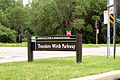
The park that became known as Theodore Wirth Park was established in 1889 with an initial acquisition of 66 acres (270,000m2), initially called Saratoga Park and named Glenwood Park in 1890.[1] In 1908, MPRB folded the garden into Glenwood Park and began further expansion to the north and west, using authorization from the Minnesota Legislature to expand into Golden Valley. In 1938, the park was renamed for Theodore Wirth, who was superintendent of Minneapolis parks for 30 years from 1906 to 1936.[2]
The park currently occupies 759 acres (3.07km2), which is 90% of the size of New York City's Central Park at 843 acres (3.41km2).
The park was the venue for the 2024 Stifel Loppet Cup international cross-country ski competition.[4]
Features
A geographic marker at one corner of the park grounds, at Wirth Parkway and Golden Valley Road, marks the 45 degrees latitude line, exactly halfway between the equator and the North Pole.[5] The badly weathered plaque was refurbished around 2006.[citation needed]
Gated entrance to garden, "Let nature be your teacher."
Golf course
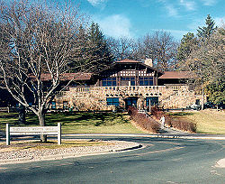
In the northern portion of Wirth Park sits a golf course, including one 18-hole course and one 9-hole par 3 course. The golf course was established in 1917 and its clubhouse constructed in 1923. In 2011, disc golf was added to the par 3 course. In the winter, much of the park is repurposed to cross country ski trails.[2]
Eloise Butler Wildflower Garden and Bird Sanctuary
In 1907 Eloise Butler, John Greer and others petitioned the Minneapolis Park and Recreation Board for space in Glenwood Park to establish a botanical garden. The park board granted the request and set aside three acres of bog, meadow and hillside for the Wild Botanical Garden, the first public wildflower garden in the United States.[6] The garden was renamed after Butler, also the garden's first curator, in 1929.[2]
This page is based on this Wikipedia article Text is available under the CC BY-SA 4.0 license; additional terms may apply. Images, videos and audio are available under their respective licenses.