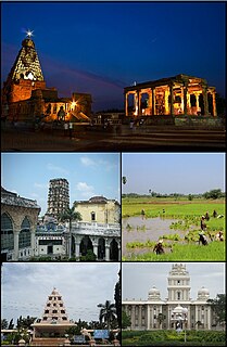
Thanjavur, formerly Tanjore, is a city in the Indian state of Tamil Nadu. Thanjavur is an important center of South Indian religion, art, and architecture. Most of the Great Living Chola Temples, which are UNESCO World Heritage Monuments, are located in and around Thanjavur. The foremost among these, the Brihadeeswara Temple, is located in the centre of the city. Thanjavur is also home to Tanjore painting, a painting style unique to the region.

Rewapronunciation (help·info) is a city in north-eastern part of Madhya Pradesh state in India. It is the administrative centre of Rewa District and Rewa Division. The city lies about 420 kilometres (261 mi) northeast of the state capital Bhopal and 230 kilometres (143 mi) north of the city of Jabalpur.The world's only Mahamritunjay Temple is situated in Rewa Fort. World's first white tiger(Mohan) was caught in Rewa in 1951 by Maharaja of Rewa, Raja Martand Singh.The Rewa Ultra Mega Solar Power Project is one of the largest single-site solar power plants in India and the world.

Mannargudi is a town in Tiruvarur district in the Indian state of Tamil Nadu. It is the headquarters of the Mannargudi taluk. The town is located at a distance of 20 km (12 mi) from the district headquarters Tiruvarur and 310 km (190 mi) from the state capital Chennai. Mannargudi is known for the Rajagopalaswamy temple, a prominent Vaishnavite shrine.

Cuddalore is the headquarters of the Cuddalore District in the Indian state of Tamil Nadu.

Pudukkottai is the administrative headquarters of Pudukkottai District in the Indian state of Tamil Nadu. It is a large town located on the banks the Vellar River, it has been ruled, at different times, by the Cholas, Mutharaiyars, Early Pandyas, Thondaimans, and the British. It is situated about 395 kilometres (245 mi) southwest of the state capital Chennai and about 55 kilometres (34 mi) southeast of Tiruchirappalli. The people in the city are employed mainly in teritiary sector activities. Tamil Nadu's first women Asiad Santhi Soundarajan is from Pudukkottai.

Thuvakudi is a town in Tiruchirapalli district in the Indian state of Tamil Nadu. It is an industrial town housing more than 250 industries and is located in the National Highway NH 65 between Tiruchirapalli and Thanjavur. The town has a dry weather, making it suitable for dry crops like cotton, chillies and millets..

Hukkeri is a Town Municipal Council and taluka in Belagavi district in the Indian state of Karnataka. Archeological studies reveal that the name Hukkeri is supposed to have been derived from the word Huvinakeri which means Street of Flowers. During Adil Shahi times, roses of good quality were grown here and were sent to Bijapur.
Karaikal district is one of the four districts of the Union Territory of Puducherry in India.
Podakkudi is a village in Thiruvarur district in the South Indian state of Tamil Nadu. The town is located at a distance of 20 km (12 mi) from the district headquarters Thiruvarur and 272 km (169 mi) from the state capital Chennai. Podakkudi is known for the Big Mosque, a prominent Islamic shrine. Nearby towns and villages are Koothanallur, Atthikadai, Budamangalam.
Kattimedu is a small village situated in Tiruvarur district of Tamil Nadu, India. It belongs to Kattimedu and Adirangam Panchayat.

Viluppuram, Villupuram, or Vizhuppuram is a Municipality and the administrative headquarters of Vizhuppuram district.
Mannangadu is one of the famous village in Tamilnadu. Mannangadu, is one of the 36 villages falls under the Musugundan Nadu in Thanjavur district, Tamilnadu, India. Mannangadu is one of the revenue village in Pattukkottai taluk. It is located on state highway Adirampattinam-Mannargudi-Kumbakonam, between Adirampattinam and Madukkur.It is the fourth largest village in Pattukkottai taluk, after Thamarankottai, Thambikottai and Aalathur. Total geographical area of the Village is 740.20 hectares.

Peikkarumbankottai is a village in the Orathanadu taluk of Thanjavur district, Tamil Nadu, India.
Sembanarkoil is a panchayat town in Tranquebar taluk in Mayiladuthurai district district in the Indian state of Tamil Nadu. The town is located in the historic Thanjavur area on the banks of the river Cauvery. The history of the place is centered around the Swarnapureeswarar Temple.

Thanjavur has a well-developed transport infrastructure. Thanjavur is well connected by Road, and Rail with most cities and towns in India

Tiruchirappalli (Tamil: தி௫ச்சிராப்பள்ளி pronunciation , also called Tiruchi or Trichy, is a city in the Indian state of Tamil Nadu and the administrative headquarters of Tiruchirapalli District. It is the fourth largest municipal corporation in Tamil Nadu and also the fourth largest urban agglomeration in the state. It is located almost at the geographic centre of the state.
Koothanallur is a town in Tiruvarur district in the South Indian state of Tamil Nadu. The town is located at a distance of 20 km (12 mi) from the district headquarters Tiruvarur and 350 km (220 mi) from the state capital Chennai. Koothanallur is known for the Big Mosque. Sri Ramanatha Swamy Thirukovil, an ancient temple at Tirurameshwaram, is located 7 km (4.3 mi) far to Koothanallur, southerly.

Alampattu is a village in the state of Tamil Nadu, Sivaganga District, India. It is 20 km from the town Karaikudi.
Rettakudi is a village in Nannilam taluk, Thiruvarur district, Tamil Nadu, India. It is located approximately 8 kilometres (5.0 mi) from Poonthottam in the Cauvery Delta.

Kalathur is a panchayat village in Peravurani panchayat Union of Thanjavur district in the Indian state of Tamil Nadu. Kalathur is a part of the Pattukkottai taluk of Thanjavur district and located 67 kilometres (42 mi) south of Thanjavur connected via State Highway 29.