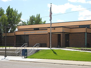
Valley County is a county in the U.S. state of Montana. Valley County was created in 1893 with area partitioned from Dawson County. As of the 2020 census, the population was 7,578. Its county seat is Glasgow. It is located on the Canada–United States border with Saskatchewan.
Hinsdale is a town in Berkshire County, Massachusetts, United States. It is part of the Metropolitan Statistical Area of Pittsfield, Massachusetts. The population was 1,919 at the 2020 census.

Opheim is a town in Valley County, Montana, United States. The population was 75 at the 2020 census.

The Rural Municipality of Lone Tree No. 18 is a rural municipality (RM) in the Canadian province of Saskatchewan within Census Division No. 4 and SARM Division No. 3. Located in the southwest portion of the province, it is southwest of the city of Swift Current. It is adjacent to the United States border, neighbouring Blaine County and Phillips County in Montana.

The Rural Municipality of Frontier No. 19 is a rural municipality (RM) in the Canadian province of Saskatchewan within Census Division No. 4 and SARM Division No. 3. Located in the southwest portion of the province, it is adjacent to the United States border, neighbouring Blaine County in Montana.

The Rural Municipality of Waverley No. 44 is a rural municipality (RM) in the Canadian province of Saskatchewan within Census Division No. 3 and SARM Division No. 2. Located in the southwest portion of the province, it is adjacent to the United States border, neighbouring Valley County in Montana.
Vandalia is a small unincorporated community in Valley County, Montana, United States. It was established in 1904 with a post office and a store along the Hi-Line of the Great Northern Railway. The community's chief industry was the manufacture of bricks that were used in public buildings across Montana. Vandalia also shares its namesake with a local dam on the Milk River that diverts water for the Glasgow Irrigation District.

The Rural Municipality of Mount Pleasant No. 2 is a rural municipality (RM) in the Canadian province of Saskatchewan within Census Division No. 1 and SARM Division No. 1. Located in the southeast portion of the province, it is adjacent to the United States border, neighbouring Renville County in North Dakota.

The Rural Municipality of Enniskillen No. 3 is a rural municipality (RM) in the Canadian province of Saskatchewan within Census Division No. 1 and SARM Division No. 1. Located in the southeast portion of the province, it is adjacent to the United States border, neighbouring Burke County and Renville County both in North Dakota.

The Rural Municipality of Lake Alma No. 8 is a rural municipality (RM) in the Canadian province of Saskatchewan within Census Division No. 2 and SARM Division No. 2. Located in the southeast portion of the province, it is adjacent to the United States border, neighbouring Sheridan County in Montana and Divide County in North Dakota.

The Rural Municipality of Surprise Valley No. 9 is a rural municipality (RM) in the Canadian province of Saskatchewan within Census Division No. 2 and SARM Division No. 2. Located in the southeast portion of the province, it is adjacent to the United States border, neighbouring Sheridan County in Montana.

The Rural Municipality of Mankota No. 45 is a rural municipality (RM) in the Canadian province of Saskatchewan within SARM Division No. 3. Located in the southwest portion of the province, it is adjacent to the United States border, neighbouring Valley County and Phillips County in Montana.

The Rural Municipality of Happy Valley No. 10 is a rural municipality (RM) in the Canadian province of Saskatchewan within Census Division No. 2 and SARM Division No. 2. Located in the southeast portion of the province, it is adjacent to the United States border, neighbouring Daniels County and Sheridan County in Montana.

The Rural Municipality of Hart Butte No. 11 is a rural municipality (RM) in the Canadian province of Saskatchewan within Census Division No. 3 and SARM Division No. 2. Located in the south-central portion of the province, it is adjacent to the United States boundary, neighbouring Daniels County in Montana.

The Rural Municipality of Old Post No. 43 is a rural municipality (RM) in the Canadian province of Saskatchewan within Census Division No. 3 and SARM Division No. 2. It is located in the southern portion of the province adjacent to the United States border, neighbouring Valley County and Daniels County in Montana.
The Rural Municipality of Moose Creek No. 33 is a rural municipality (RM) in the Canadian province of Saskatchewan within Census Division No. 1 and SARM Division No. 1.

The Rural Municipality of Kingsley No. 124 is a rural municipality (RM) in the Canadian province of Saskatchewan within Census Division No. 5 and SARM Division No. 1. It is located in the southeast portion of the province.

The Rural Municipality of Lajord No. 128 is a rural municipality (RM) in the Canadian province of Saskatchewan within Census Division No. 6 and SARM Division No. 2. It is located in the southeast portion of the province.

Hinsdale is an unincorporated community and census-designated place in Valley County, Montana, United States. The town's population was 217 and the community's population as a whole was 583 as of the 2010 census. The community is located on the Milk River and U.S. Route 2, with Montana Highway 537 headed north out of town and South Bench Road crossing the railroad tracks and running south of town. Hinsdale has a post office with ZIP code 59241.

Beaverton is an unincorporated community in Valley County, Montana, United States, located near Beaver Creek on the Valley County/Phillips County line. The community itself is all but a ghost town, with First Creek Seeds being the only remaining feature. Beaverton is halfway between the town of Saco and the community of Hinsdale.


