The Boulder River is a 77-mile (124 km) tributary of the Jefferson River in southwestern Montana in the United States.

The Clark Fork, or the Clark Fork of the Columbia River, is a river in the U.S. states of Montana and Idaho, approximately 310 miles (500 km) long. The largest river by volume in Montana, it drains an extensive region of the Rocky Mountains in western Montana and northern Idaho in the watershed of the Columbia River. The river flows northwest through a long valley at the base of the Cabinet Mountains and empties into Lake Pend Oreille in the Idaho Panhandle. The Pend Oreille River in Idaho, Washington, and British Columbia, Canada which drains the lake to the Columbia in Washington, is sometimes included as part of the Clark Fork, giving it a total length of 479 miles (771 km), with a drainage area of 25,820 square miles (66,900 km2). In its upper 20 miles (32 km) in Montana near Butte, it is known as Silver Bow Creek. Interstate 90 follows much of the upper course of the river from Butte to Saint Regis. The highest point within the river's watershed is Mount Evans at 10,641 feet (3,243 m) in Deer Lodge County, Montana along the Continental Divide.

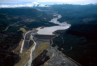
The Pend Oreille River is a tributary of the Columbia River, approximately 130 miles (209 km) long, in northern Idaho and northeastern Washington in the United States, as well as southeastern British Columbia in Canada. In its passage through British Columbia its name is spelled Pend-d'Oreille River. It drains a scenic area of the Rocky Mountains along the U.S.-Canada border on the east side of the Columbia. The river is sometimes defined as the lower part of the Clark Fork, which rises in western Montana. The river drains an area of 66,800 square kilometres (25,792 sq mi), mostly through the Clark Fork and its tributaries in western Montana and including a portion of the Flathead River in southeastern British Columbia. The full drainage basin of the river and its tributaries accounts for 43% of the entire Columbia River Basin above the confluence with the Columbia. The total area of the Pend Oreille basin is just under 10% of the entire 258,000-square-mile (670,000 km2) Columbia Basin. Box Canyon Dam is currently underway on a multimillion-dollar project for a fish ladder.

The Dirty Devil River is an 80-mile-long (130 km) tributary of the Colorado River, located in the U.S. state of Utah. It flows through southern Utah from the confluence of the Fremont River and Muddy Creek before emptying into the Colorado River at Lake Powell.

The Youngs River is a tributary of the Columbia River, approximately 27 miles (43 km) long, in northwest Oregon in the United States. It drains part of the Northern Oregon Coast Range in the extreme northwest corner of state, entering the Columbia via Youngs Bay just approximately 10 miles (16 km) from its mouth.

The Lewis River is a tributary of the Columbia River, about 95 miles (153 km) long, in southwestern Washington in the United States. It drains part of the Cascade Range north of the Columbia River. The drainage basin of the Lewis River covers about 1,046 square miles (2,709 km2). The river's mean annual discharge is about 6,125 cubic feet per second (173.4 m3/s). Unlike nearby Lewis County and Fort Lewis the Lewis River was not named for Meriwether Lewis, but rather for A. Lee Lewis, an early colonizer who homesteaded near the mouth of the river.
The North Fork Toutle River is a tributary of the Toutle River in southwestern Washington in the United States. The river has its headwaters near Spirit Lake, on the north side of Mount St. Helens, and flows 39 miles (63 km) to the Toutle River, about 17 miles (27 km) upstream of its confluence with the Cowlitz River. The largest tributary is the Green River, which joins near the unincorporated town of Toutle.

The Klickitat River is a tributary of the Columbia River, nearly 96 miles (154 km) long, in south-central Washington in the United States. It drains a rugged plateau area on the eastern side of the Cascade Range northeast of Portland, Oregon. In 1986, 10 miles (16 km) of the river were designated Wild and Scenic from the confluence with Wheeler Creek, near the town of Pitt, to the confluence with the Columbia River.

The Flathead River, in the northwestern part of the U.S. state of Montana, originates in the Canadian Rockies to the north of Glacier National Park and flows southwest into Flathead Lake, then after a journey of 158 miles (254 km), empties into the Clark Fork. The river is part of the Columbia River drainage basin, as the Clark Fork is a tributary of the Pend Oreille River, a Columbia River tributary. With a drainage basin extending over 8,795 square miles (22,780 km2) and an average discharge of 11,380 cubic feet per second (322 m3/s), the Flathead is the largest tributary of the Clark Fork and constitutes over half of its flow.

The Umatilla River is an 89-mile (143 km) tributary of the Columbia River in northern Umatilla County, Oregon, United States. Draining a basin of 2,450 square miles (6,300 km2), it enters the Columbia near the city of Umatilla in the northeastern part of the state. In downstream order, beginning at the headwaters, major tributaries of the Umatilla River are the North Fork Umatilla River and the South Fork Umatilla River, then Meacham, McKay, Birch, and Butter creeks.
The Colville River is a 60-mile (100 km) long tributary of the Columbia River in northeastern Washington in the United States.
The Yaak River is a tributary of the Kootenai River in Montana.
The Coweeman River is a tributary of the Cowlitz River, in the South West corner of the U.S. state of Washington. Its name comes from the Cowlitz word ko-wee-na, meaning "short one", referring to a short Indian who once lived along the river.

The Suiattle River is a river in the U.S. state of Washington.
The Middle Fork John Day River is a 73-mile (117 km) tributary of the North Fork John Day River in the U.S. state of Oregon. It originates in the Blue Mountains of northeast Oregon in the Malheur National Forest near Austin and flows generally west to the North Fork about 18 miles (29 km) above Monument. The Middle Fork drainage basin covers about 806 square miles (2,090 km2).
Ashlu Creek is a short and swift river-like creek in British Columbia. It is a tributary of the Squamish River and enters it about 24.3 km northwest of Squamish.
The South Fork Alsea River is a tributary of the Alsea River in the U.S. state of Oregon. It begins at northeast of Horton on the east side of the Central Oregon Coast Range and flows generally northwest to near Alsea. There it joins the North Fork Alsea River to form the main stem.
The East Fork South Fork McKenzie River is a tributary of the South Fork McKenzie River in Lane County in the U.S. state of Oregon. It begins in and passes through part of the Willamette National Forest of the Cascade Range. Flowing generally northwest along the base of Sawtooth Ridge, it empties into Cougar Reservoir on the South Fork McKenzie River, about 5 miles (8 km) upstream of that stream's mouth on the McKenzie River.
Beaver Creek is a tributary of the Crooked River in the U.S. state of Oregon. It is formed by the confluence of its two forks in southeastern Crook County, a sparsely populated part of Central Oregon. North Fork Beaver Creek flows south and then west around Laughlin Table. South Fork Beaver Creek drains the slopes of Snow Mountain and Funny Butte in southwestern Grant County before joining the North Fork.
The South Fork Umatilla River is a tributary of the Umatilla River in Umatilla County in the U.S. state of Oregon. Its headwaters lie in the Umatilla National Forest in the Blue Mountains of northeastern Oregon near Pileup Saddle and Black Mountain. The South Fork flows generally north between Goodman Ridge and Bobsled Ridge to meet the North Fork Umatilla River near Graves Butte. Together the forks form the main stem Umatilla.
