
The River Churnet is a river in Staffordshire, England. It is a tributary of the River Dove.
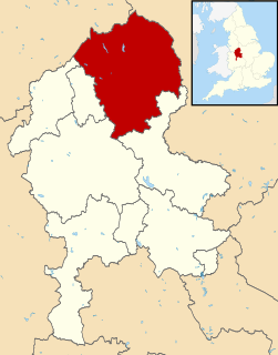
Staffordshire Moorlands is a local government district in Staffordshire, England. Its council, Staffordshire Moorlands District Council, is based in Leek and is located between the city of Stoke-on-Trent and the Peak District National Park. The 2001 census recorded the population as 94,489.
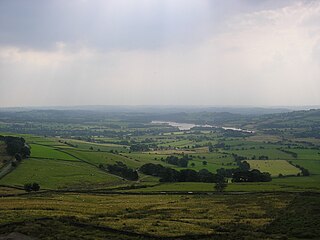
Tittesworth Reservoir is a water storage reservoir near Leek, Staffordshire, England, fed by the River Churnet. The reservoir and associated water treatment works are owned and operated by Severn Trent Water. The reservoir was built in 1858 and extended in 1963. Tittesworth is the second largest reservoir by volume in the county of Staffordshire. The Peak District Boundary Walk runs past the reservoir.

Staffordshire Moorlands is a constituency represented in the House of Commons of the UK Parliament since 2010 by Karen Bradley, a Conservative who served as Secretary of State for Culture, Media and Sport between 2016 and 2018, before she became Secretary of State for Northern Ireland from 2018 to 2019. As with all constituencies, the constituency elects one Member of Parliament (MP) by the first past the post system of election at least every five years. This seat has seen a swing to the Conservatives at the past four elections.
Waterhouses is a village in the south of the Staffordshire Peak District in England. It is around 8 miles from Leek and Ashbourne, being nearly the halfway point between the two towns on the A523 road, which roughly follows the southern boundary of the Peak District National Park. Waterhouses is also a civil parish, created in 1934 when the parishes of Calton, Cauldon, Waterfall and part of Ilam were merged; previously the village of Waterhouses was on the boundary of Waterfall and Cauldon parishes. The hamlet of Winkhill is also in the parish. The population of the civil parish at the 2011 census was 1,134.

Alstonefield is a village and civil parish in the Peak District National Park and the Staffordshire Moorlands district of Staffordshire, England about 7 miles (11 km) north of Ashbourne, 10 miles (16 km) east of Leek and 16 miles (26 km) south of Buxton. The parish had a population of 274 according to the 2001 census, increasing to 304 at the 2011 census.

Quarnford is a village and civil parish in the Staffordshire Moorlands district of Staffordshire, England. According to the 2001 census it had a population of 244, reducing marginally to 242 at the 2011 census. The village is in the Peak District, between Buxton and Leek.
Butterton is a small village in the Staffordshire Peak District of England. It overlooks the Manifold Valley and Ecton Hill, which rises 1,212 feet above sea level. Butterton lies 5 miles east of Leek and roughly 8 miles from Alton Towers theme park. The village is just west of the limestone area, and so is mainly built of local sandstone. It contains a Grade II listed church. In the centre of Butterton there is an unusual ford where the Hoo Brook runs along the village street.

Horton is a village and civil parish in the English county of Staffordshire. The population of the civil parish as taken at the 2011 census was 781. It is situated about 3 miles (5 km) W of Leek.

Ball Haye Green is an area of Leek in Staffordshire, England. The area was historically an estate in the township of Tittesworth. It was developed as a suburb of Leek from the 1820s, when the Leek Building Society erected 42 houses between 1824 and 1829. The suburb was extended in the 20th century by the building of housing estates.
Hulme End is a small hamlet in Staffordshire, England. It is located in the Peak District National Park about 10 miles north of Ashbourne. A natural gateway to the Manifold valley, the settlement is located beside the river Manifold where it crosses the road from Hartington to Warslow.

Onecote is a village and civil parish on the B5053 road, near Leek, in the Staffordshire Moorlands district, in the county of Staffordshire, England. The population as taken at the 2011 census was 220. Onecote has a parish church dedicated to St Luke. The Peak District Boundary Walk runs through the village.
Rushton is a civil parish in Staffordshire, England. The village within the civil parish, usually known as Rushton Spencer, is about 4 miles (6.4 km) north of Leek and 7 miles (11 km) south of Macclesfield, on the A523 road which runs between these towns.

Heaton is a small village and civil parish in Staffordshire, England. It is about 4 miles (6.4 km) north of Leek and about 7 miles (11 km) south of Macclesfield.

Leekfrith is a civil parish in the Staffordshire Moorlands, in Staffordshire, England, north of the town of Leek. The population of the civil parish at the 2011 census was 363.
Tittesworth is a civil parish in the Staffordshire Moorlands, in Staffordshire, England. It extends from the edge of the town of Leek in the south-west to Blackshaw Moor in the north-east. In the east is the village of Thorncliffe. To the west is the civil parish of Leekfrith, where the boundary is the River Churnet.To the east is the civil parish of Onecote. Tittesworth Brook runs westwards through the area from Thorncliffe, and flows into the Churnet.

Stanley is a small village in the Staffordshire Moorlands district of Staffordshire, England, about 4 miles (6.4 km) southwest of Leek. The village of Bagnall is about 1 mile (1.6 km) to the south.

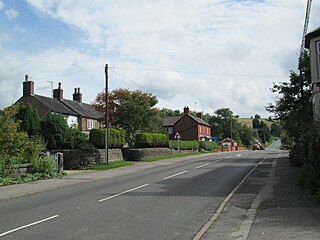
Longsdon is a village and civil parish in the Staffordshire Moorlands district of Staffordshire, England, about 1.5 miles (2.4 km) southwest of Leek, on the A53 road.
Tittesworth is a civil parish in the district of Staffordshire Moorlands, Staffordshire, England. It contains six listed buildings that are recorded in the National Heritage List for England. All the listed buildings are designated at Grade II, the lowest of the three grades, which is applied to "buildings of national importance and special interest". The parish contains the village of Thorncliffe and is otherwise rural. The listed buildings consist of farmhouses and farm buildings, a spring head cover, and a milepost.

Heathylee is a civil parish in the district of Staffordshire Moorlands in north-east Staffordshire, England.
