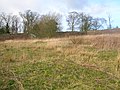
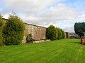
Thorntoun School was opened by Barnardo's in September 1971 for children with emotional difficulties aged 11 to 16 years. The school closed in 1990 and Thorntoun is now a nursing home. The complex lies between the villages of Springside (North Ayrshire) and Crosshouse, Kilmarnock in East Ayrshire, Scotland. The old Thorntoun mansion house was demolished in the late 1960s, leaving the West Lodge, some of the home farm outbuildings, the stables and the walled garden as 'memorials' to the ancient history of the site. Many fine trees remain from the estate policies and the surviving gardens are very well maintained (2007). An entrance with a slight deviation from the old course has been created to serve the large modern buildings which house the nursing home.
In 1823 the historian Robertson[1] describes "Thornton" as being "situated about half way betwixt Irvine and Kilmarnock: the manor or place (palace) is an elegant modern mansion, set down on the brow of a considerable height, overlooking, from amid its fine old timber and more recent plantings, a great expanse of rich country."
Thorntoun, 1912, Unmarked, but after the 'd' of Bankhead.The West Lodge at Thorntoun.
In 1866 James Paterson, another historian, brought up locally, gives 'Thorntoun' as "This property, situated to the west of Busbie (Knockentiber), is about 300 acres (1.2km2) in extent. It belonged, of old, according to Wood, to one of the branches of the Montgomerie family."[2]
The Montgomerie, Mure and Ross families
Etymology
Near Thorntoun in 1604[3] was a Thornhill. This fact, combined with the consistent spelling over the years suggests that the name relates to 'Thorns' i.e., either Blackthorn (Sloe) or Hawthorn. Both species are still common in the area today. A 'Toun' or 'Ton' was a farm and its outbuildings, originally an area fenced or walled off, with a dwelling within.[4]
Thorntoun was at first part of the Barony of Kilmaurs and then later it was placed within the Barony of Robertoun, Parish of Kilmaurs. The estate is first recorded as belonging to Murthhaw or Murchaw de Montgomery, who is mentioned in the Ragman Rolls (a list of those loyal to Edward I of England) of 1296. A Johne of Montgomery of Thornetoun is mentioned in a legal document of 1482, forfeiting the estate to Lord Home by order of King James V. By the beginning of the seventeenth century Thorntoun had passed into the ownership of another ancient and renowned Ayrshire family, the Mures (or Muirs), a branch of the Mures of Rowallan Castle near Kilmaurs. James Mure, Burgess of Glasgow, had married Margaret, a daughter of Robert Ross of Thorntoun on 27 June 1607 and inherited the property through his spouse. Nothing is known of how and when the Ross's, another ancient Ayrshire family, had come to possess Thorntoun. Hew (Hugh) was one son, a merchant in Edinburgh, his will is dated 4 Nov 1679 and another son, James succeeded to the property of Thorntoun, and married a Janet Naper, who died in 1626. Robert Muir, son of James & Janet, is mentioned in a document of 1634.[2]
The Cuninghame Family
Archibald Muir of Thorntoun was knighted by King William III in 1698 and his only daughter, Margaret, married John Cuninghame of Caddel, in the Parish of Ardrossan, in 1699. They inherited Thorntoun and Caddel and had two sons and three daughters. Archibald succeeded his father and John became a successful merchant in Lisbon (Portugal), eventually retiring to live at Carmelbank (previously called Mote), adjacent to Thorntoun. Their father was married a second time to a daughter of Mr. Stevenson of Montgreenan, by whom they had another sixteen children. This John Cuninghame died in 1753.
The gravestone of the Cuninghame's of Caddel and Thorntoun, Kilmaurs.The Coat of Arms of the Cuninghames of Caddel.
Archibald Cuninghame, who was a captain in Boscawen's 29th. Regiment of Foot, married Christiana, eldest daughter of Andrew Macredie of Perceton in 1754. They had three sons, John, Andrew and Archibald and five daughters. Their eldest son was Lieut-Col. John Cuninghame, born in 1756 and died in 1836. He entered the army in 1775 and served in America (now the USA) and the West Indies. He was severely wounded whilst fighting the French in the Caribbean island of St. Kitts. John recovered to serve on board the 74 gun, HMS Montague, at the great Caribbean naval victory of the Battle of the Saintes against the French who were commanded by Admiral Count François Joseph Paul de Grasse. He left the army as a lieutenant-colonel in 1802. John's spouse was Sarah Peebles, only daughter of Major John Peebles in Irvine, late of the 42nd regiment, She was born in 1783 and died in 1854. They had nine children, Andrew, John, Archibald, Anna, Christiana, Helen, Margaret, Catherine and Sarah. Many of the family died in childhood or when relatively young. Catherine married Clarence Esme Stuart of Oldenham Abbey, Hertfordshire. Christiana first inherited, followed by Sarah. The colonels' rental value of the property in 1799 was £300 (Scots) per annum, compared with that of the Earl of Eglinton, who had an income of £1,120 (Scots) from his estates.[5] The Lieut-Col and his family are commemorated and / or buried at the family burial plot in the cemetery of St Maurs-Glencairn kirk in Kilmaurs.[1]
The Wrey Family
Thorntoun Estate
The Location of Thorntoun Estate, East Ayrshire.
Carmel Bank from near Holm Farm. 2007.
Sarah Cuninghame's spouse was George Bourchier Wrey from North Devon. They had a son, George Edward Bourchier Wrey who had succeeded to the property by 1912. He appears to have inherited Carmelbank from his great-uncle, John Cuninghame by this date.[5] The combined rental income of Thorntoun and Carmelbank was £2,640 12s 0d., the second highest in the parish, only exceeded by Robert Morris Pollock-Morris of Craig house.[5] This is a reversal for both of the situation in 1799 and may reflect earnings from the establishment of collieries, etc. rather than the straightforward 'traditional' income from farms and the like.
Coat of arms
The coat of arms is a shakefork with a cinquefoil, for Glengarnock: a cross moline within a bordure invected, for Caddel: three stars within a bordure invected, for Muir of Thorntoun; and a crest of a unicorn's head. The motto is "Over fork over" and as such is unchanged from that of the senior branch, the Cunninghames of Kilmaurs, Earls of Glencairn.[1]
The Barony of Robertoun
This barony, once part of the Barony of Kilmaurs, ran from Kilmaurs south to the river Irvine. It had no manor house and belonged to the Eglinton family latterly. The following properties were part of the barony: parts of Kilmaurs, Craig, Gatehead, Woodhills, Greenhill, Altonhill, Plann, Hayside, Thorntoun, Rash-hill Park, Milton, Windyedge, Fardelhill, Muirfields, Corsehouse and Knockentiber.
The Darien Affair
Crosshouse as seen from Thorntoun.
The Darien Company was an attempt by the Scots to set up a trading colony in America in the late 1690s, however the opposition from England and elsewhere was so great that the attempt failed with huge losses and great financial implications for the country and for individuals. Half of the whole circulating capital of Scotland was subscribed and mostly lost. In Cunninghame some examples of losses are Sir Archibald Mure of Thorntoun (£1000), Major James Cunninghame of Aiket (£200), Sir William Cunninghame of Cunninghamhead (£1000), William Watson of Tour (£150) and James Thomson of Hill in Kilmaurs (£100). In modern terms a thousand pounds loss in the 17th century must have been a devastating blow to the family finances.[6]
The journals of Major John Peebles
Located in the Cuninghame of Thorntoun Papers in the National Archives of Scotland is the American Revolution journal of Captain John Peebles (1739–1823), a grenadier officer of the 42nd (Royal Highland Regiment or Black Watch). The journal provides an enlightening insight into the life and activities of the British army during the rebellion. John Peebles was John Cuninghame's father-in-law.
In 1780 Captain John Peebles noted in his journal the "General Rules for Manouvring the Battn. by the Commanding Officer"; appended to these directions are a series of signals for giving orders to the troops.
Signals by drum
The following extracts illustrate the battlefield manoeuvres which drum 'signals' could signal.
Preparative, to begin firing by Companies, which is to go on as fast as each is loaded till the first part of the General when not a shot more is ever to be fired.
Grenadrs. March. to advance in Line.
Point of War. to Charge.
To Arms. to form the Battn. (whether advancing or Retreating in Column) upon the leading division.
Double flam. to halt Upon the word forward, in forming, the Divisions to run up in Order.
The New Jersey Brigade and the Monmouth Campaign
Here are a few extracts from John's American War of Independence journal:
Monday 22d. June rain in the night The Army... moved on to the Black Horse a small Village about 7 or 8 miles from Mount holly & Encampd in two lines facing NW—Genl. Kniphausens Division on the left—the Queens Rangers on our Right... Maxwells Corps of Rebels left the Black horse this Morng.
Monday 29th. June … Genl. Knyphausens Division moved on to Middletown, with the Provision & baggage Train - & wounded.
Evidence from Ordnance Survey (OS) and other maps
William Aiton's map of Ayrshire showing Thornton.
Timothy Pont's map of 1604 as published by Johan Blaeu in 1654 clearly marks Thorntoun[3] so do Ainslie's map of 1821,[7] Armstrong's map[8] of 1775 and Herman Moll's map of The Shire of Renfrew with Cuningham in 1745. General Roy's Military Survey map of Scotland (1745–55) shows the site named as simply 'Thorn'.
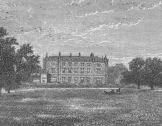
The view of Thorntoun from Crosshouse.
Thomson's map of 1828 gives some detail, showing two entrances and driveways, with substantial woodlands and an enclosed park on the Springside boundary, as used for deer or cattle. He also marks the name 'Mains', indicating the home farm, apparently situated to the right of the house on the 'east' driveway on the Crosshouse side.[9] This was later rebuilt above the 'West' Lodge (1898 OS), however buildings remain in the 'old' site up until the time of the 1921-28 OS map. This map also indicates a building roughly in the centre of the walled garden. The walls show no signs of typical conservatory-style greenhouses built against them, so this may be a large 'greenhouse'. The stone is red sandstone with freestone corners and coping stones. The materials were landed at Troon harbour and brought here by cart. A 'trig point' is carved on the corner of the walled garden nearest the old quarry.[10] A well is shown near the walled garden in the vicinity of the modern housing. An old freestone quarry is shown on the 1860 map, close to the trig point on the walled garden. Buildings are indicated on the 1912 OS map as lying fairy close to the northern wall of the walled gardens. Only vague foundations and scattered stones now exist at the site in 2007.
The 1912 map appears to show an enclosed area, partially wooded, in the nearby field, of a similar size and shape to the walled garden. This may be a fox covert or cover for pheasants. No sign of this feature is now extant (2007).
A small cottage used to stand near the entrance to the new driveway into the nursing home.[10] The 1912 map shows a track running into the estate at this point and this building may have served as a lodge house. The name 'West Lodge' itself suggests that a second lodge existed at one time and the 1911 OS clearly marks this lodge situated at what is now the realigned entrance to the main driveway.
A number of local names appear to have been lost, such as Thornhill (1604), Greenside, Hayside, and Laurieslaw from 1828 and Montgomery Holme (1745–1828). A Laurieland Row, Crawfurdhill and Thorntoun Row were present in 1860. A Thornyhill cottage is however present (2007) near Busbiehill.
The Royal Mail re-organised its postal districts in the 1930s and at that point many hamlets and localities ceased to exist officially, such as Sprighill, Corsehill, Bankhead and Kirklands.[11][12] The present Springside was called Bankhead up until at least the 1921 - 1928 OS, the hamlet of Springside being originally clustered around the railway station.
A number of Lime kilns are marked on 1860 OS, the nearest being at Holme and West Gatehead farms.
In 1776[13] Thorntoun is marked on the toll road to Irvine and the two milestones are shown.
A horse trough was present on the left of the main road facing Springside, in between the West Lodge and the lane up to Thorntoun Mains; the trough has long vanished, but its niche in the bank with its side walls is still there. This was a turnpike or toll road, with the nearest toll house located at Crosshouse. The 1860 OS map show two milestones were near Thorntoun, one close to the junction of the lane down to Hallbarns and Cauldhame farms and the other on the left facing Crosshouse, before the Holm Burn bridge, indicating 4 miles (6.4km) to Irvine and three to Kilmarnock. Most milestones were buried during the Second World War so as not to provide assistance to invading troops, German spies, etc. This happened all over Scotland, however Fife at least was more fortunate than Ayrshire, for the stones were taken into storage and put back in place after the war had finished.[14]
The name 'turnpike' originated from the original 'gate' used being just a simple wooden bar attached at one end to a hinge on the supporting post. The hinge allowed it to 'open' or 'turn' This bar looked like the 'pike' used as a weapon in the army at that time and therefore we get 'turnpike'. The term was also used by the military for barriers set up on roads specifically to prevent the passage of horses. In addition to providing better surfaces and more direct routes, the turnpikes settled the confusion of the different lengths given to miles,[9] which varied from 4,854 to nearly 7,000 feet (2,100m). Long miles, short miles, Scotch or Scot's miles (5,928ft), Irish miles (6,720ft), etc. all existed. 5,280 feet (1,610m) seems to have been an average! Another important point is that when these new toll roads were constructed the turnpike trusts went to a great deal of trouble to improve the route of the new road and these changes could be quite considerable as the old roads tended to go from farm to farm, hardly the shortest route. The tolls on roads were abolished in 1878 to be replaced by a road 'assessment', which was taken over by the county council in 1889.
The woodland policies contain a mixture of mature oak, Norway maple, beech, copper beech, willow, horse chestnut, aspen, rhododendron, Scots pine, alder, ash, elm, monkey puzzle, willow, sycamore, holy, elder, yew, lime, hawthorn, blackthorn and other species. The woodland floor has drifts of snowdrops, bluebells and some primroses, together with ground ivy, bird's-foot trefoil, coltsfoot, three-veined sandwort, vetch, ladys mantle, red campion, bistort, foxgloves, tuberous comfrey, ivy, yellow saxifrage, pendulous sedge, brambles, etc. An area of the woodland is a genuine 'bluebell wood.' The large leaved Persian Ivy (Hedera colchica)[15] grows at the walled garden, a relict of the exotic plantings of yesteryear, as is the very unusual stand of Butcher's Broom. The ground flora of the Thorntoun policies is typical of the semi-natural diversity of many deciduous woodlands in Ayrshire, particularly of those associated with current or previous country estates. The bird fauna is quite diverse, including pigeons, rooks, starlings, blackbirds, kestrels, etc. Hedgehogs are present (2007).
The Collieries and Coal Pits
The 1860, 1898–1904 and, 1911 and 1912 OS maps all show that the extent to which the Thorntoun House was surrounded by collieries, coal pits and freight only railway or 'tram' lines. Collieries were located near Cauldhame farm (Cauldhame and Springhill (Pit No.4), one at Crosshouse, one at Holme farm and at Bankhead (one called West Thorntoun), Springhill (Pit No.1) and Springhill (Pit No.2) at Sprighill, and another between Busbiehill and Warwickhill. These were all served by standard gauge mineral railway lines, criss-crossing the countryside; they all now lifted, with only a few embankments left to indicate their original course. The Thorntoun colliery beside Holme farm had a miner's row and a railway which ran over several wooden bridges down to join the surviving railway through Gatehead at Holm ley, close to the Laigh Milton viaduct. In 1860 numerous old and current coal pits dotted the area. The bing of Springhill (Pit No.3) still lies close to Springside in the field that may have been the Thorntoun deer park.
Miscellaneous and Trivia
Thorntoun in the snow. 12 March 2006
Strawhorn [16] states in 1951 that a fair number of inhabitants are of Cornish extraction, having been brought up here to break a coal workers strike in the 1880s.
Etymology
Carmel, the oldest form of which is Caremuall, is thought to be derived, according to McNaught,[5] from the Gaelic 'Car' meaning a 'fort', and 'Meall'. meaning a hill. Therefore, 'The fort on the hill'.
The road running down to Springside is known as the 'Thorntoun Brae' and on the left, just before Thorntoun bridge over the Garrier Burn was the local curling pond, clearly marked on the 1911 OS map[12]
A mill-wand was the rounded piece of wood acting as an axle with which several people would role a millstone form the quarry to the mill and to permit this the width of some early roads was set at a 'mill-wand breadth'. The nearest mills to Thorntoun were those at Busbie beside Crosshouse and Laigh Milton mill, where the building, weir and part of the wheel still exist (2007).
Margaret Muir, was the spouse of Frederick Cunninghame, a merchant in Kilmarnock. She died on 17 March 1685 and could therefore have been a daughter of James Mure and Janet Naper.
In 1902 a Mrs. Margaret Sturrock, née Finnie was living at Thorntoun House.[17]
A Trig point at the walled garden marks a height of 169 feet (52m) elevation above sea level.
Letters survive in the National Archives of Scotland concerning the imprisonment of Margaret Cuninghame at Lucca in Tuscany, Italy for evangelical teaching, 1853-1854.
The Cuninghames of Thorntoun & Caddel held title to lands in Ayr and tenements in Glasgow, 1573–1836, including, tacks of lands in Stirling.
The estate factors' accounts of Caddell and Thorntoun, survive for the period 1700-1947. Thorntoun house may have been demolished in 1947.
Sir Philip Bourchier Sherard Wrey stood for election to the Southern Rhodesia legislative council in 1920.
Chapeltoun is an estate on the banks of the Annick Water in East Ayrshire, Scotland. This is a rural area famous for its milk and cheese production and the Ayrshire or Dunlop breed of cattle.
Lambroughton is a village in the old Barony of Kilmaurs, Scotland. This is a rural area famous for its milk and cheese production and the Ayrshire or Dunlop breed of cattle.
Cunninghamhead is a hamlet in North Ayrshire, Scotland. It was the centre of the lands of Cunninghamhead, Perceton and Annick Lodge in Cunninghame. This mainly rural area is noted for its milk and cheese production and the Ayrshire, Cunninghame or Dunlop breed of cattle.
Clan Cunningham is a Scottish clan. The traditional origins of the clan are placed in the 12th century. However, the first contemporary record of the clan chiefs is in the thirteenth century. The chiefs of the Clan Cunningham supported Robert the Bruce during the Wars of Scottish Independence. In the 15th and 16th centuries, the Clan Cunningham feuded with the Clan Montgomery. Historically, the chief of Clan Cunningham held the title of Earl of Glencairn. However, in modern times the chief of the clan is Cunningham of Corsehill. On 18 December 2013, Sir John Christopher Foggo Montgomery Cunninghame, Baronet of Corsehill, was recognized by Lord Lyon as Clan Chief after the chiefship had been vacant for over 200 years.
The old Barony and castle of Corsehill lay within the feudal Baillerie of Cunninghame, near Stewarton, now East Ayrshire, Scotland.
Kerelaw Castle is a castle ruin situated on the coast of North Ayrshire, Scotland in the town of Stevenston.
The village or hamlet of Gatehead is located in East Ayrshire, Parish of Kilmaurs, Scotland. It is one and a quarter miles from Crosshouse and one and a half miles from Kilmarnock. In the 18th and 19th centuries the locality was a busy coal mining district. The settlement runs down to the River Irvine where a ford and later a bridge was located.
The village of Springside is in North Ayrshire, Parish of Dreghorn, Scotland. It is three miles from Irvine, 1+1⁄2 miles west of Crosshouse, and four miles from Kilmarnock. In the 18th, 19th and mid-20th centuries, the locality was a highly industrialised coal mining district. The settlement is on the Garrier Burn, which forms the boundary with East Ayrshire. Springside had a population of around 1364 in 1991. The A71 now bypasses the village, 1⁄4 mile to the south.
Knockentiber is a village in East Ayrshire, Parish of Kilmaurs, Scotland. Knockentiber is two miles west-northwest of Kilmarnock and 1⁄2 mile northeast of Crosshouse. Latitude:55.6193°N Longitude:4.5455°W and grid reference NS397392. The population was 359 in 1991, however the population is much higher following the construction of several housing estates (2007). In the 18th and 19th and mid 20th centuries the locality was a highly industrialised coal mining district. The settlement is on the Carmel Burn, which runs into the River Irvine, around one mile to the south.
Fergushill is a small community in North Ayrshire, Parish of Kilwinning, Scotland. The Barony of Fergushill was held by the Fergushill family of that Ilk and the area has a complex history.
Kilmaurs Place, The Place or Kilmaurs House, is an old mansion house and the ruins of Kilmaurs Tower grid reference NS41234112 are partly incorporated, Kilmaurs, East Ayrshire, Scotland. The house stands on a prominence above the Carmel Water and has a commanding view of the surrounding area. Once the seat of the Cunningham Earls of Glencairn it ceased to be the main residence after 1484 when Finlaystone became the family seat.
Montgreenan is an estate in North Ayrshire, Parish of Kilwinning, Scotland. The Lugton Water runs through the policies and farmland of Montgreenan. Nearby are the hamlets of Torranyard and Auchentiber.
Kilmaurs Castle was located on the lands of Jocksthorn Farm near Kilmaurs in East Ayrshire, Scotland. It is described by Timothy Pont in the early 17th century as "Ye castell is ane ancient ftronge building belonging to ye Earls of Glencairne environed with a fair park called Carmell wod from ye vatter of Carmell yat runs by it." Dobie goes on to state that "The old baronial manor place is supposed to have been situated about a mile south-east of Kilmaurs, where some ruins can still be pointed out on the farm of Jock's-thorn, probably the original Villam de Cuninghame - the first possession of the family." The castle is not to be confused with the later Cunninghame family possession known as Kilmaurs Place which Dobie calls "..comparatively modern" in 1876.
The Castle of Clonbeith is in the old feudal Baillerie of Cunninghame, near Auchentiber, on a sideroad off the B778, in what is now North Ayrshire, Scotland.
Caldwell is a mansion and old estate with the remains of a castle nearby. These lands lie close to the Lugton Water and the villages of Uplawmoor in East Renfrewshire and Lugton in East Ayrshire.
Busbie Castle was situated in what is now known as Knockentiber, a village in East Ayrshire, Parish of Kilmaurs, Scotland. Knockentiber is 2 miles (3.2 km) WNW of Kilmarnock and 1/2 mile NE of Crosshouse. The castle overlooked the Carmel Glen and its Burn, which runs into the River Irvine, a mile or so to the south, after passing through the old Busbie Mill.
The Lands of Lainshaw lie in Strathannick and were part of the Lordship of Stewarton, in East Ayrshire, Scotland. Lainshaw House is a category B listed mansion, lying in a prominent position above the Annick Water and its holm in the Parish of Stewarton, Scotland. Part of the much older Lainshaw Castle is contained within the several later building phases of the present day Lainshaw House. The names 'Langshaw' or 'Langschaw' were used in historic times. Law Mount near the High and Laigh Castleton farms has been suggested as the site of the original castle, granted in the 12th century to Godfrey de Ross by Hugo de Morville.
Towerlands or Tourlands was a small estate of 70 to 80 acres of good quality land in the parish of Irvine and the old barony of Kilmaurs, North Ayrshire, Scotland, situated near the more extensive property of Bourtreehill, the lands of which surrounded it on three sides. The name suggests that a medieval stone or wood 'tower' structure of some sort existed, but no record of this appears to exist.
The lands of Broomlands or Broumlands formed a small country estate about a mile to the east of Irvine, North Ayrshire, Scotland situated on the east bank of the Annick Water in the Parishes of Dreghorn and Irvine.
The Lands of Tour and Kirkland (NS416406) formed a small estate close to the old Kirktoun and St Maurs-Glencairn collegiate church about 1 km south-east of Kilmaurs, East Ayrshire, Parish of Kilmaurs, Scotland. The word 'Tour' in Scots refers to a 'tower' and 'kirk' to a parish church.
References
1 2 3 4 Robertson, George (1823). A Genealogical Account of the Principal Families in Ayrshire. Pub. A. Constable, Irvine.
1 2 Paterson, James (1866). History of the Counties of Ayr and Wigton. V.III. – Cunninghame. Pub. J. Stillie. Edinburgh.
This page is based on this Wikipedia article Text is available under the CC BY-SA 4.0 license; additional terms may apply. Images, videos and audio are available under their respective licenses.