Worstead is a village and civil parish in the English county of Norfolk. It lies 3 miles (5 km) south of North Walsham, 5 miles (8 km) north of Wroxham, and 13 miles (21 km) north of Norwich. The village is served by Worstead railway station on the Bittern Line. For the purposes of local government, the parish falls within the district of North Norfolk.

Fakenham is a market town and civil parish in Norfolk, England. It is situated on the River Wensum, about 25 miles north west of Norwich. The town is the junction of several local roads, including the A148 from King's Lynn to Cromer, the A1067 to Norwich and the A1065 to Swaffham.

Taverham is a village and civil parish in Norfolk, in England. It is approximately 5 miles (8 km) north-west of Norwich. Taverham sits on the River Wensum. Taverham forms part the wider Norwich Built-up area.

Norwich North is a constituency represented in the House of Commons of the UK Parliament since 2009 by Chloe Smith, a Conservative.

Norwich South is a constituency in Norfolk represented in the House of Commons of the Parliament of the United Kingdom, since 2015 by Clive Lewis, of the Labour Party.

Gateley is a village and civil parish in the Breckland district of Norfolk, England.

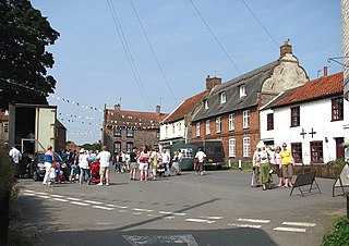
Burnham Market is an English village and civil parish near the north coast of Norfolk. It is one of the Burnhams, a group of three adjacent villages that were merged: Burnham Sutton, Burnham Ulph and Burnham Westgate. Burnham Market was rated among the "20 most beautiful villages in the UK and Ireland" by Condé Nast Traveler in 2020.

New Buckenham is a village and civil parish in the English county of Norfolk.

Bawdeswell is a small rural village and civil parish in Norfolk, England. At the time of the 2011 census it had a population of 828 and an area of 487 hectares. The village is situated almost in the centre of Norfolk about 14 miles (23 km) northwest of Norwich. For the purposes of local government it falls within the Upper Wensum Ward of Breckland District Council and the Elmham and Mattishall Division of Norfolk County Council. It is on a Roman road that ran east–west between Durobrivae near modern Peterborough and Smallburgh, crossing the Fen Causeway.

Bylaugh is a civil parish in Norfolk, England 4.5 miles (7.2 km) north-east of East Dereham and 13.5 miles (21.7 km) WNW of Norwich. For the purposes of local government it falls within the Upper Wensum Ward of Breckland District Council and the Elmham and Mattishall Division of Norfolk County Council. According to the 2001 census it had a population of 65. At the 2011 census the population remained less than 100 and was included in the civil parish of Sparham.
Lingwood and Burlingham is a civil parish in the English county of Norfolk, comprising the large village of Lingwood together with the smaller villages of Burlingham Green, North Burlingham and South Burlingham. The villages are all within 4 kilometres (2.5 mi) of each other, some 15 kilometres (9.3 mi) equidistant from the town of Great Yarmouth and the city of Norwich.

Haddiscoe is a village and civil parish in the South Norfolk district of Norfolk, England, about 16 miles (26 km) southeast of Norwich. The parish is on the county boundary with Suffolk, about 7 miles (11 km) west-northwest of Lowestoft. The parish includes the hamlet of Thorpe-next-Haddiscoe, about 1 mile (1.6 km) north of Haddiscoe village.
Lyng is a village and civil parish in the English county of Norfolk. It is situated on the River Wensum, some 10 km (6.2 mi) north-east of the town of East Dereham and 20 km (12 mi) north-west of the city of Norwich.

Twyford is a hamlet and civil parish in the English county of Norfolk. It is situated on the A1067 road, some 12 km (7.5 mi) south-east of the town of Fakenham and 28 km (17 mi) north-west of the city of Norwich.

Whitlingham is a small churchless parish and hamlet at the mouth of the River Wensum in Norfolk, England. It is located 3 miles (5 km) east of Norwich, on the south bank of the River Yare, reached from Trowse along Whitlingham Lane.

Hockering is a village and civil parish in Norfolk, England. At the 2001 census the parish had a population of 628. By 2007, the district estimated that this had risen to 665. being measured at 711 in the 2011 Census.

North Tuddenham is a civil parish in the English county of Norfolk, North Tuddenham is 3 miles (4.8 km) east of East Dereham, and is close to the A47 road.

Drayton, Norfolk, is a suburban village in the county of Norfolk and district of Broadland 4.3 miles (6.9 km) north west of Norwich. It is situated on the A1067 road between Hellesdon and Taverham.

Thurning is a small dispersed village and civil parish in the English county of Norfolk and district of North Norfolk, near the border with Broadland. The population at the 2011 Census remained less than 100 and is recorded together with the neighbouring civil parish of Hindolveston.
