Thumping Dick Hollow

Last updated
Thumping Dick Hollow
ThumpingDickHollow-Cave1-Entrance.jpg
No-Name Cave
USA Tennessee location map.svg
Red pog.svg
Thumping Dick Hollow, Sewanee, TN
Location in Sewanee, Tennessee
Length2 miles (3.2 km)East-West
Width0.1 to 1 mile (0.16 to 1.61 km)
Geography
Location Franklin County, Tennessee, United States
Coordinates 35°13′40.22″N85°57′19.41″W / 35.2278389°N 85.9553917°W / 35.2278389; -85.9553917 Coordinates: 35°13′40.22″N85°57′19.41″W / 35.2278389°N 85.9553917°W / 35.2278389; -85.9553917
Traversed by Sewanee Perimeter Trail

Thumping Dick Hollow, also known as Thumping Dick Cove, is a small cove in Franklin County, south Tennessee, within the domain of the University of the South and town of Sewanee. It is noted for its unusual name, old-growth forest, and caves.

Contents

Description

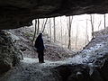
Thumping Dick Hollow is a small cove with multiple sinkholes and caves including Solomon's Temple. It is also noted for its old growth forest. [1] It is one of the segments of the Sewanee Perimeter Trail. In 1973, Dick Cove was designated as a National Natural Landmark by the National Park Service. [2]

Origin of name

There are multiple traditions as to the origin of the unusual name. The hollow was referred to as early as 1858 before the University of the South was built. A popular version relates that a local resident named "Dick" built a water-powered grain mill in the 19th century; when in operation, the mill made a "thumping" sound that was heard throughout the surrounding forest. [3] Another version of the origin states that the a hydro powered sump pump or sawmill made a thumping sound when in operation. [4]

Location

Thumping Dick Hollow located off of the old Stagecoach route of the Breakfield Road in Sewanee, Tennessee and forms part of the Sewanee Perimeter Trail. It is approximately 700 feet (210 m) in elevation below Breakfield Road. From gate #7 on Breakfield Road, follow the path beyond the gate for .8 miles (1.3 km) until it crosses a stream with a collapsed bridge. Cross over the stream and follow a faint path to the left until the entrance to the Columned Entrance Cave is visible. The second cave, Solomon's Temple, is further ahead around the cliff on the right.

In literature

Noted early 20th century New England author, drama critic, and Yale professor Walter Prichard Eaton wrote of the hollow. In his 1922 collection of essays Penguin, Persons, and Peppermints, Eaton describes a visit to the hollow in early spring while celebrating the Southern American gift for colorful place names. [5]

Notes

  1. Sewanee Best Day Hikes Retrieved June 5, 2016
  2. "National Natural Landmarks - National Natural Landmarks (U.S. National Park Service)". www.nps.gov. Retrieved 2019-03-28. Year designated: 1973
  3. (EATON) Eaton, Walter P., Penguin, Persons, and Peppermints, p. 18, BOOKS FOR LIBRARIES PRESS, 1922 (reprinted 1969), Retrieved August 14, 2013
  4. Priestley, M. and Allen, G., Go Take a Hike, A guide to hiking on the domain of the University of the South, pp. 30-31, Second Edition, 2004, Printed by the University of the South.
  5. (EATON)

Related Research Articles

<span class="mw-page-title-main">Franklin County, Tennessee</span> County in Tennessee, United States

Franklin County is a county in the U.S. state of Tennessee. It is located on the eastern boundary of Middle Tennessee in the southern part of the state. As of the 2010 census, the population was 41,052. Its county seat is Winchester. Franklin County is part of the Tullahoma-Manchester, TN Micropolitan Statistical Area.

<span class="mw-page-title-main">Sinkhole</span> Geologically-formed topological depression

A sinkhole is a depression or hole in the ground caused by some form of collapse of the surface layer. The term is sometimes used to refer to doline, enclosed depressions that are locally also known as vrtače and shakeholes, and to openings where surface water enters into underground passages known as ponor, swallow hole or swallet. A cenote is a type of sinkhole that exposes groundwater underneath. A sink or stream sink are more general terms for sites that drain surface water, possibly by infiltration into sediment or crumbled rock.

<span class="mw-page-title-main">Well of Souls</span> Cave in the Dome of the Rock, Jerusalem, underneath the Foundation stone

The Well of Souls, is a partly natural, partly man-made cave located inside the Foundation Stone under the Dome of the Rock shrine on the Temple Mount, Jerusalem. During the Crusader period, it was known to Christians as the "Holy of Holies", referring to the inner sanctum of the former Jewish Temple, which according to modern scholarship, was probably located on top of the Foundation Stone.

<span class="mw-page-title-main">Hocking Hills State Park</span> State park in Ohio, United States

Hocking Hills State Park is a state park in the Hocking Hills region of Hocking County, Ohio, United States. In some areas the park adjoins the Hocking State Forest. Within the park are over 25 miles (40 km) of hiking trails, rock formations, waterfalls, and recess caves. The trails are open from dawn to dusk, all year round, including holidays.

<span class="mw-page-title-main">Harishchandragad</span> Fort in Maharashtra State, India

Harishchandra Fort is a hill fort in the Ahmednagar district of India. Its history is linked with that of Malshej Ghat, kothale village and it has played a major role in guarding and controlling the surrounding region.

<span class="mw-page-title-main">Oldbury Camp</span>

Oldbury Camp is the largest Iron Age hill fort in south-eastern England. It was built in the 1st century BC by Celtic British tribes on a hilltop west of Ightham, Kent, in a strategic location overlooking routes through the Kentish Weald. The fort comprises a bank and ditch enclosing an area of about 50 hectares, with entrances at the north-east and south ends. Wooden gates barred the entrances. Archaeological excavations carried out in the 1930s and 1980s found that the hill fort's interior had probably not been permanently occupied. It had been abandoned around 50 BC and the north-east gate had been burned down, possibly due to a Roman invasion. The wooded southern part of Oldbury Camp is now owned and managed by the National Trust and is open to the public.

<span class="mw-page-title-main">Carboniferous Limestone</span> Limestone deposited during the Dinantian Epoch of the Carboniferous Period

Carboniferous Limestone is a collective term for the succession of limestones occurring widely throughout Great Britain and Ireland that were deposited during the Dinantian Epoch of the Carboniferous Period. These rocks formed between 363 and 325 million years ago. Within England and Wales, the entire limestone succession, which includes subordinate mudstones and some thin sandstones, is known as the Carboniferous Limestone Supergroup.

<span class="mw-page-title-main">Shoushan (Kaohsiung)</span> Mountain

Shoushan is a mountain in Gushan District, Kaohsiung, Taiwan, north of the main entrance to Kaohsiung Harbor. It was named Ape Hill by the Dutch in the 17th century to describe many Formosan rock macaques on this mountain. It is also called Chaishan (柴山) and includes the Snake Hill in its northern part, and Long Life Hill (壽山) – named by Japanese in 1911-1915 for the crown-prince Hirohito – in the southern part. In some old maps, the peak of the hill is called Saracen's Head. Now it is a nature park where biological diversity can be seen.

<span class="mw-page-title-main">South Cumberland State Park</span> State park in Tennessee

South Cumberland State Park is a state park in the middle and southeast portions of Tennessee on the Cumberland Plateau.

Barff Peninsula is a peninsula forming the east margin of Cumberland East Bay, South Georgia Island. It is 8 miles (13 km) long and extends northwest from Sörling Valley to Barff Point, its farthest extremity. It was probably first seen by the British expedition under James Cook in 1775. The peninsula as a whole takes its name from Barff Point, which was named for Royal Navy Lieutenant A.D. Barff of HMS Sappho, who, assisted by Captain C.A. Larsen, sketched a map of Cumberland Bay in 1906. Barff Point is considered the eastern headland of East Cumberland Bay.

<span class="mw-page-title-main">Liendo</span> Municipality in Cantabria, Spain

Liendo is a municipality located in the autonomous community of Cantabria, Spain. According to the 2007 census, the city had a population of 995 inhabitants. Its capital is Hazas.

<span class="mw-page-title-main">Onondaga Cave State Park</span> State park in Missouri, United States

Onondaga Cave State Park is a Missouri state park located on the Meramec River approximately 5 miles (8.0 km) southeast of the village of Leasburg. The park was established in 1982. Park activities include cave tours, camping, fishing, hiking, picnicking, and swimming.

<span class="mw-page-title-main">Grassy Cove</span> Geographical region in Cumberland County, Tennessee, United States

Grassy Cove is an enclosed valley in Cumberland County, Tennessee, United States. The valley is notable for its karst formations, which have been designated a National Natural Landmark. Grassy Cove is also home to a small unincorporated community.

<span class="mw-page-title-main">Cedars of Lebanon State Park</span> State park in Tennessee, United States

Cedars of Lebanon State Park is a state park in Wilson County, Tennessee, in the southeastern United States. It consists of 900 acres (364 ha) situated amidst the 9,420-acre (3,810 ha) Cedars of Lebanon State Forest. The park and forest are approximately 10 miles (16 km) south of Lebanon, Tennessee.

<span class="mw-page-title-main">Lost Cove Cave</span> Cave in Tennessee, United States

Lost Cove Cave, also known as Buggytop Cave, is a cave in Franklin County, south Tennessee near the towns of Sewanee and Sherwood and close to the Alabama border. It is noted for its large main entrance and the extensive archeological artifacts of the Woodland and Mississippian periods found inside.

The Sewanee Perimeter Trail is a private mixed-use mountain top trail of 20 miles (32 km) owned and maintained by the University of the South in Sewanee, TN.

<span class="mw-page-title-main">Cherney Maribel Caves County Park</span> County park in Wisconsin (US)

Cherney Maribel Caves County Park is a county park located near Maribel in Manitowoc County, Wisconsin. The park occupies 75 acres along the West Twin River. Cherney Maribel Caves consists of eleven caves along a rugged cliff line that runs parallel with the West Twin River. Maribel New Hope Cave, Tartarus Cave, Sinkhole Cave and Split Rock Cave are all established gated caves that need guides to visit the entire caves, they are gated due to past vandalism to the Speleothems and protect the current Speleothems.

<span class="mw-page-title-main">Lost Cove, Tennessee</span>

Lost Cove is a small valley in southern Tennessee near the Alabama border. It is noted for its history including Native American and Appalachian Settlements as well as its natural formations including Caves and Sinkholes.

The 1973 Mount Gambier cave diving accident was a scuba diving incident in 1973 at a flooded sinkhole known as "The Shaft" near Mount Gambier in South Australia. The incident claimed the lives of four recreational scuba divers: siblings Stephen and Christine M. Millott, Gordon G. Roberts, and John H. Bockerman. The four divers explored beyond their own planned limits, without the use of a guideline, and subsequently became lost, eventually exhausting their breathing air and drowning. As of May 2015, they are the only known fatalities at the site. Four other divers from the same group survived.

References