
West Yorkshire is a metropolitan and ceremonial county in the Yorkshire and the Humber region of England. It borders North Yorkshire to the north and east, South Yorkshire and Derbyshire to the south, Greater Manchester to the south-west, and Lancashire to the west. The city of Leeds is the largest settlement.

Mirfield is a town and civil parish in the Metropolitan Borough of Kirklees, West Yorkshire, England. Historically part of the West Riding of Yorkshire, it is on the A644 road between Brighouse and Dewsbury. At the 2011 census it had a population of 19,563. Mirfield forms part of the Heavy Woollen District.
Kirkburton is a village, civil parish and ward in Kirklees in West Yorkshire, England. It is 5 miles (8 km) south-east of Huddersfield. Historically part of the West Riding of Yorkshire, the township comprised the villages of Kirkburton and Highburton and several hamlets, including Thunder Bridge, Thorncliffe, Storthes Hall and Linfit. According to the 2011 census the civil parish had a population of 26,439, while the village had a population of 4,299.

Kirklees is a metropolitan borough of West Yorkshire, England. The borough comprises the ten towns of Batley, Birstall, Cleckheaton, Dewsbury, Heckmondwike, Holmfirth, Huddersfield, Meltham, Mirfield and Slaithwaite. It is governed by Kirklees Council. Kirklees had a population of 422,500 in 2011; it is the third-largest metropolitan district in England by area size, behind Doncaster and Leeds.

Shelley is a village in the civil parish of Kirkburton, in the Kirklees district, in the county of West Yorkshire, England. The village is 3 miles (5 km) north of Holmfirth and 6 miles (10 km) south-east of Huddersfield.

Huddersfield is a market town in the Metropolitan Borough of Kirklees in West Yorkshire, England. It is the administrative centre and largest settlement in the Kirklees district. The town is in the foothills of the Pennines. The River Holme's confluence into the similar-sized Colne is to the south of the town centre which then flows into the Calder in the north eastern outskirts of the town.

Highburton is part of the township of Kirkburton, a village in the county of West Yorkshire, England. It is five miles southeast of Huddersfield. It occupies much of the high ground that can be found at the top of the steep inclines of Far Dene and Slant Gate and is a mixture of densely congregated housing estates and open pastoral farmland.

Lepton is a village near Huddersfield in the parish of Kirkburton, in the Kirklees district of West Yorkshire, England. It is 4.25 miles (7 km) to the east of Huddersfield on the A642 road, 120 metres (390 ft) above the town centre directly north of Lepton Great Wood. In 1931 the parish had a population of 3,323.
Kirkheaton is a village in the parish of Kirkburton, in the Kirklees district of West Yorkshire, England, Historically, it is part of the West Riding of Yorkshire. It is 3 miles (5 km) north-east of Huddersfield, in the Dalton ward of Kirklees Council. In 2021 it had a population of 3,496.

Shepley is a village in the civil parish of Kirkburton, in Kirklees, West Yorkshire, England. It lies 8 miles (13 km) south south east of Huddersfield and 6 miles (9.7 km) north west of Penistone.

Flockton is a village in the civil parish of Kirkburton, in Kirklees, West Yorkshire, England. It is halfway between Huddersfield and Wakefield. In 2020, the population of Flockton and Flockton Green was estimated to be 2,107.

Thurstonland is a village in the civil parish of Kirkburton, in Kirklees, West Yorkshire, England. It has a population of almost 400.

Farnley Tyas is a village in the parish of Kirkburton, in the Kirklees district, in the county of West Yorkshire, England 3 miles (4.8 km) south east of Huddersfield. It is located on a hilltop between Almondbury, Castle Hill, Thurstonland and Honley. It is mostly rural and farmland with private housing and some local authority social housing. In 1921 the parish had a population of 486.

Myers Wood is a wooded area in the village of Kirkburton, West Yorkshire, England. It forms part of a heavily forested area to the west of the village, occupying the rise in the valley leading up to Storthes Hall and beyond. It is directly west of the main Penistone Road, opposite Riley. Saville Wood is directly south, close to Thunder Bridge. Local residents consider the wood to be of poor quality due to the absence of woodland management.

Roberttown is a village, in the township of Liversedge in Kirklees, West Yorkshire, England and is historically, part of the West Riding of Yorkshire.
Thorncliffe is a hamlet in the civil parish of Kirkburton, in the Kirklees district, in the county of West Yorkshire, England.
Grange Moor is a village in the civil parish of Kirkburton, in the Kirklees district of West Yorkshire, England, between Huddersfield and Wakefield. In 2019, it had an estimated population of 1,101.

Taylor Hill is a semi rural/industrial urban village of the town of Huddersfield in the English county of West Yorkshire. It lies on a hill above the A616 road to Honley and Penistone and the eastern bank of the River Holme, in the Holme Valley, approximately 1.5 miles (2 km) to the south of Lockwood, west of Newsome and to the north of Berry Brow.
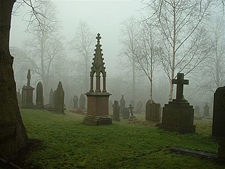
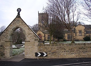
Kirkburton is a civil parish in the metropolitan borough of Kirklees, West Yorkshire, England. It contains 164 listed buildings that are recorded in the National Heritage List for England. Of these, two are listed at Grade I, the highest of the three grades, two are at Grade II*, the middle grade, and the others are at Grade II, the lowest grade. The list also includes two listed buildings outside the parish but in Kirkburton ward; both of these are at Grade II. There are no major towns in the parish, but it contains villages and smaller settlements including Farnley Tyas, Flockton, Flockton Green, Grange Moor, Highburton, Kirkheaton, Lepton, Shelley, Shepley, Stocksmoor, Thunder Bridge, and Thurstonland. The parish is otherwise rural.
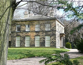
Kirkburton Hall, formerly known as Kirkburton Town Hall, and before that, as Springfield House, is a former municipal building in Penistone Road in Kirkburton, a town in West Yorkshire in England. The building, which was previously the offices and meeting place of the Kirkburton Urban District Council and is now a private residence, is a grade II listed building.

