
Kent is a county in South East England and one of the home counties. It borders Greater London to the northwest, Surrey to the west and East Sussex to the southwest, and Essex to the north across the estuary of the River Thames; it faces the French department of Pas-de-Calais across the Strait of Dover. The county town is Maidstone. It is the fifth most populous county in England, the most populous non-metropolitan county and the most populous of the home counties.

Leeds Castle is a castle in Kent, England, 7 miles (11 km) southeast of Maidstone. It is built on islands in a lake formed by the River Len to the east of the village of Leeds.

Maidstone is the largest town in Kent, England, of which it is the county town. Maidstone is historically important and lies 32 miles (51 km) east-south-east of London. The River Medway runs through the centre of the town, linking it with Rochester and the Thames Estuary. Historically, the river carried much of the town's trade as the centre of the agricultural county of Kent, known as the Garden of England. There is evidence of settlement in the area dating back before the Stone Age. The town, part of the borough of Maidstone, had an approximate population of 100,000 in 2019. Since World War II, the town's economy has shifted from heavy industry towards light industry and services.
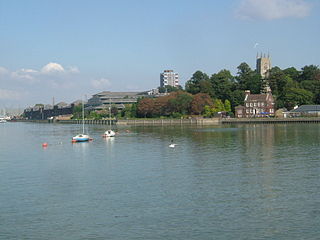
The River Medway is a river in South East England. It rises in the High Weald, West Sussex and flows through Tonbridge, Maidstone and the Medway conurbation in Kent, before emptying into the Thames Estuary near Sheerness, a total distance of 70 miles (113 km). About 13 miles (21 km) of the river lies in East Sussex, with the remainder being in Kent.

The North Downs are a ridge of chalk hills in south east England that stretch from Farnham in Surrey to the White Cliffs of Dover in Kent. Much of the North Downs comprises two Areas of Outstanding Natural Beauty (AONBs): the Surrey Hills and the Kent Downs. The North Downs Way National Trail runs along the North Downs from Farnham to Dover.

Tonbridge and Malling is a local government district with borough status in Kent, England. Tonbridge is the largest settlement but the authority is based in the modern development of Kings Hill.

The Borough of Maidstone is a local government district with borough status in Kent, England. Its administrative centre is Maidstone, the county town of Kent.

Hadlow is a village in the borough of Tonbridge and Malling in Kent, England. It is situated in the Medway valley, north-east of Tonbridge and south-west of Maidstone.

Bearsted is a village and civil parish with railway station in mid-Kent, England, two miles (3.2 km) east of Maidstone town centre.

Thurnham is a village and civil parish which lies at the foot of the North Downs 3 miles (4.8 km) north east of Maidstone in the Borough of Maidstone and ceremonial county of Kent in England. It had a population of 1,085 in 2001 including Weavering, which increased to 1,205 following the 2011 Census.

Allington is an almost entirely modern village situated alongside the sides of the A20 road west of Maidstone in Kent. It is part of the built-up area of Maidstone.
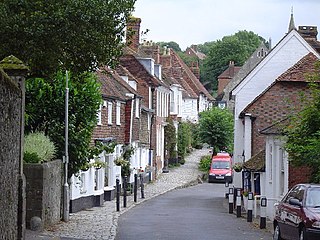
Sutton Valence is a village about five miles (8 km) SE of Maidstone, Kent, England on the A274 road going south to Headcorn and Tenterden. It is on the Greensand Ridge overlooking the Vale of Kent and Weald. St Mary's Church is on the west side of the village on Chart Road, close to the junction of the High Street with the A274. Another landmark is Sutton Valence Castle on the east side of the village, of which only the ruins of the 12th-century keep remain, under the ownership of English Heritage.

Detling Hill is a hill forming part of the North Downs in Kent, north-east of Maidstone, and is situated in the Kent Downs Area of Outstanding Natural Beauty. The typical southern escarpment of the North Downs is found here, and produces dramatic views over the Low Weald. The North Downs Way passes along the hill just south of the summit.

Faversham and Mid Kent is a constituency represented in the House of Commons of the UK Parliament. Since 2015, the seat has been represented by Helen Whately of the Conservative Party.

Barming is a civil parish in the Maidstone District of Kent, England. It lies to the west of Maidstone and at the 2011 census had a population of 2,690. The eastern end of the parish is part of the built-up area of Maidstone, although the remainder is much more rural. The River Medway forms its southern boundary.
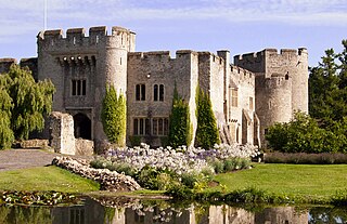
Allington Castle is a stone castle in Allington, Kent, just north of Maidstone, in England. The first castle on the site was an unauthorised fortification, built during "The Anarchy" (1135–1153) and torn down later in the century when royal control was reasserted. It was replaced by a manor house, which was fortified with royal permission in the 13th century. Various alterations and expansions were made by successive owners over the following two centuries. The property was developed into a fortified compound with six towers at irregular intervals along the curtain wall and domestic buildings in the interior, including one of the first long galleries built in England. In 1554 it was seized by the Crown in the course of dispossessing its owner, Sir Thomas Wyatt the Younger, after the failure of his rebellion against Queen Mary.

Staplehurst is a town and civil parish in the borough of Maidstone in Kent, England, 9 miles (14 km) south of the town of Maidstone and with a population of 6,003. The village lies on the route of a Roman road, which is now incorporated into the course of the A229. The name Staplehurst comes from the Old English 'stapol' meaning a 'post, pillar' and 'hyrst', as a 'wooded hill'; therefore, 'wooded-hill at a post', a possible reference to a boundary marker at the position of All Saints' church atop the hill along the road from Maidstone to Cranbrook. The parish includes the hamlet of Hawkenbury.

White Horse Wood is a recently created English country park near Thurnham to the north of Maidstone, Kent. Located within the Kent Downs Area of Outstanding Natural Beauty, the park is a Site of Nature Conservation Interest.

The 2007 Maidstone Borough Council election took place on 3 May 2007 to elect members of Maidstone Borough Council in Kent, England. One third of the council was up for election and the council stayed under no overall control.

There are 27 scheduled monuments in Maidstone, Kent, England. In the United Kingdom, a scheduled monument is an archaeological site or historic building of "national importance" that has been given protection against unauthorised change by being placed on a list by the Secretary of State for Digital, Culture, Media and Sport; Historic England takes the leading role in identifying such sites. Scheduled monuments are defined in the Ancient Monuments and Archaeological Areas Act 1979 and the National Heritage Act 1983. They are also referred to as scheduled ancient monuments. There are about 20,000 scheduled monument entries on the list and more than one site can be included in a single entry. While a scheduled monument can also be recognised as a listed building, Historic England considers listed building status as a better way of protecting buildings than scheduled monument status. If a monument is considered by Historic England to "no longer merit scheduling" it can be removed from the schedule.


