
Sherwood Forest is the remnants of an ancient royal forest in Nottinghamshire, England, having a historic association with the legend of Robin Hood.

The Danelaw was the part of England between the early tenth century and the Norman Conquest under Anglo-Saxon rule in which Danish laws applied. The Danelaw originated in the conquest and occupation of large parts of eastern and northern England by Danish Vikings in the late ninth century. The term applies to the areas in which English kings allowed the Danes to keep their own laws following the tenth-century English conquest in return for the Danish settlers' loyalty to the English crown. "Danelaw" is first recorded in the early 11th century as Dena lage.

Nottinghamshire is a ceremonial county in the East Midlands of England. The county borders South Yorkshire to the north-west, Lincolnshire to the east, Leicestershire to the south, and Derbyshire to the west. The largest settlement is the city of Nottingham (323,632), which is also the county town.
Guthrum was King of East Anglia in the late 9th century. Originally a native of Denmark, he was one of the leaders of the "Great Summer Army" that arrived in Reading during April 871 to join forces with the Great Heathen Army, whose intentions were to conquer the kingdoms of Anglo-Saxon England. The combined armies were successful in conquering the kingdoms of East Anglia, Northumbria, and parts of Mercia, and overran Alfred the Great's Wessex, but were ultimately defeated by Alfred at the Battle of Edington in 878. The Danes retreated to their stronghold, where Alfred laid siege and eventually Guthrum surrendered.

A thing, also known as a folkmoot, assembly, tribal council, and by other names, was a governing assembly in early Germanic society, made up of the free people of the community presided over by a lawspeaker. Things took place regularly, usually at prominent places accessible by travel. They provided legislative functions, as well as social events and trade opportunities. In modern usage, the meaning of this word in English and other languages has shifted to mean not just an assemblage of some sort but simply an object of any kind. Thingstead or "thingstow" is the English term for the location where a thing was held.
Gamla Uppsala is a parish and a village outside Uppsala in Sweden. It had 17,973 inhabitants in 2016.
Fingest is a village in Buckinghamshire, England. It is in the Chiltern Hills near the border with Oxfordshire. It is about six miles WSW of High Wycombe. It lies in the civil parish of Hambleden.

Gummer's How is a hill in the southern part of the Lake District, on the eastern shore of Windermere, near its southern end. How, derived from the Old Norse word haugr, is a common local term for a hill or mound.

Torksey is a small village in the West Lindsey district of Lincolnshire, England. The population of the civil parish at the 2011 census was 875. It is situated on the A156 road, 7 miles (11 km) south of Gainsborough and 9 miles (14 km) north-west of Lincoln, and on the eastern bank of the tidal River Trent, which here forms the boundary with Nottinghamshire.

Ainderby Quernhow is a village and civil parish in North Yorkshire, England. The village is situated on the B6267 Thirsk to Masham road just east of the A1(M) and is about five miles west of Thirsk. The population of the civil parish was estimated at 70 in 2014.

The Great Heathen Army, also known as the Viking Great Army, was a coalition of Scandinavian warriors who invaded England in 865 AD. Since the late 8th century, the Vikings had been engaging in raids on centres of wealth, such as monasteries. The Great Heathen Army was much larger and aimed to conquer and occupy the four kingdoms of East Anglia, Northumbria, Mercia and Wessex.
Howe is a small village and civil parish in the Hambleton District of North Yorkshire, England. It is situated near Ainderby Quernhow and the A61 and 5 miles (8 km) west of Thirsk. The population of the civil parish was estimated at 20 in 2015.

Death in Norse paganism was associated with diverse customs and beliefs that varied with time, location and social group, and did not form a structured, uniform system. After the funeral, the individual could go to a range of afterlives including Valhalla, Fólkvangr, Hel, and living on physically in the landscape. These afterlives show blurred boundaries and exist alongside a number of minor afterlives that may have been significant in Nordic paganism. The dead were also seen as being able to bestow land fertility, often in return for votive offerings, and knowledge, either willingly or after coercion. Many of these beliefs and practices continued in altered forms after the Christianisation of the Germanic peoples in folk belief.

Howtown is a hamlet in Cumbria, England, situated at a small harbour on the east shore of Ullswater in the Lake District. It lies within the civil parish of Martindale.

Thingoe was a hundred of Suffolk, consisting of 31,850 acres (128.9 km2).

Hannah's Meadows is a Site of Special Scientific Interest in the Teesdale district of south-west County Durham, England. It consists of three fields, located at Low Birk Hatt Farm, on the north side of Blackton Reservoir, in Baldersdale, some 5 miles (7 km) west of the village of Cotherstone. The site is named after Hannah Hauxwell, whose farm it was for over 50 years.

Haugating was a Thing in medieval Norway. Haugating served as an assembly for the regions around Vestfold and the area west of Oslofjord. It was located at Tønsberg in Vestfold, Norway.
Perlethorpe cum Budby is a civil parish in the Newark and Sherwood district, within the county of Nottinghamshire, England. The overall area had a population of 172 at the 2021 census. The parish lies in the north west of the county and district. It is 125 mi (201 km) north of London, 8 mi (13 km) north east of Mansfield and 20 mi (32 km) north of the city of Nottingham. The parish and wider area is at the heart of Sherwood Forest, which is associated with the Robin Hood legend. Thoresby Hall, which is a notable ducal country house and estate is also within the boundaries of the parish.

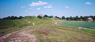
Kings Clipstone is a settlement and civil parish, in the Newark and Sherwood district, in the county of Nottinghamshire, England. The parish lies in the west of the county, and north west within the district. It is 122 miles north of London, 15 miles north of the city of Nottingham, and 5 miles north east of the market town of Mansfield. In the 2021 census, the parish had a population of 312. The parish touches Clipstone village, Edwinstowe, Rufford and Warsop. The parish was formerly part of the wider Clipstone parish, on 1 April 2011 it became a separate parish. The area is within Sherwood Forest, well known for the Robin Hood legend.
