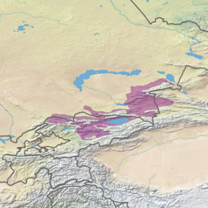
Tian Shan foothill arid steppe

Last updated
Tian Shan foothill arid steppe
Aksu Jabgly 3.JPG
Aksu Canyon, Kazakhstan
Ecoregion PA0818.png
Ecoregion territory (in purple)
Ecology
Realm Palearctic
Biome Temperate grasslands, savannas, and shrublands
Geography
Area129,000 km2 (50,000 sq mi)
Countries Kazakhstan, Kyrgyzstan, China
Coordinates 43°30′N79°00′E / 43.500°N 79.000°E / 43.500; 79.000

The Tian Shan foothill arid steppe ecoregion (WWF ID: PA0818) covers the northern and western approaches to the Tian Shan mountains, centered on Lake Issyk-Kul in Kyrgyzstan. This region receives more moisture from Central Asia, thereby supporting more vegetation and diversity of plant and animal species than the deserts to the south. [1] [2]

Contents

Location and description

The ecoregion stretches around the lower altitudes of the Tian Shan mountain ridge, running for approximately 1,000 km from western Kyrgyzstan to a small section inside the western reaches of Xinjiang Province in China. [1] The foothills of the northwestern Tian Shan are a series of ridges and lake basins in this region. Elevations for this ecoregion are 150 - 660 meters.

Climate

Several different climate classifications are represented in the ecoregion, both semi-arid and humid. The most widespread in the northeast is cold semi-arid (Köppen climate classification (BSk)). This climate is generally characterized as having precipitation greater than a true desert, and also a colder temperature. [3] [4] The western areas of the ecoregion, and the closer areas to the main ridge, are warmer, particularly in the summer, with high temperatures above 32 degrees C in July. [1]

Flora and fauna

The semi-desert of the lower foothills feature Fescue ( Festuca ) and feather grass ( Stipa ), with sagebrush and similar shrubs (genus Artemisia), and salt-tolerant tamarisk ( Tamarix ). [1] Common mammals include red fox, corsac fox, wolf, steppe cat, weasels, ferrets, and various voles and shrews. [1]

See also

Related Research Articles

<span class="mw-page-title-main">Zhongar-Alatau National Park</span>

Zhongar-Alatau National Park, also Jungar Alatau, or Dzungurian Alatau, was created in 2010 to protect the unique ecology of the Dzungarian Alatau, an isolated, glaciated mountain range in Kazakhstan, on the southeastern border with China. One stated reason for creating the park is to protect forests of wild fruit trees, including apricots, barberry, cherries, and currants. Approximately 1% of the land area of the park is forested with Sievers Apple trees, which are the progenitors of all cultured apple varieties in the world. The park is 300 km long (west-to-east), and spreads across Aksu District, Sarkand District and Alakol District of Almaty Region, 300 km northeast of the regional city of Almaty.

<span class="mw-page-title-main">Helanshan montane conifer forests</span> Ecoregion in the Helan Mountains

The Helanshan montane conifer forests ecoregion covers an isolated, forested mountain range surrounded by desert and semi-arid basins. As such, it has been called a "mountain island in the sky", and supports endemic species of plants and animals. The region supports the endangered Helan Shan pika.

<span class="mw-page-title-main">Tian Shan montane conifer forests</span> Ecoregion in the Tian Shan Mountains

The Tian Shan montane conifer forests ecoregion covers the "forest belt" of the Tian Shan mountains - generally the north-facing slopes that get enough moisture, and are warm enough, for trees to grow. This conifer belt is found mostly between 1,500 and 2,700 meters.

<span class="mw-page-title-main">Tian Shan montane steppe and meadows</span>

The Tian Shan montane steppe and meadows ecoregion covers a 2,000 km long stretch of grasslands of the isolated Tian Shan mountains of Central Asia. It is characterized by high-altitude flat and rolling grasslands.

<span class="mw-page-title-main">Pamir alpine desert and tundra</span> Ecoregion in the Pamir Mountains

The Pamir alpine desert and tundra ecoregion covers the high plateau of the Pamir Mountains, at the central meeting of the great mountain ranges of Central Asia: Himalaya, Karakoram, Hindu Kush, Kunlun, and Tian Shan. It is a region of relatively high biodiversity due to its central location and high elevation differentials, but it also acts as a barrier between the climate and habitats of north and south Asia.

<span class="mw-page-title-main">Central Tibetan Plateau alpine steppe</span> Ecoregion in the Tibetan Plateau

The Central Tibetan Plateau alpine steppe ecoregion covers the high alpine plateau that stretches over 1,600 kilometres (1,000 mi) across the Tibetan Plateau to Qinghai Lake in China. Because of the high altitude—much it over 5,000 metres (16,000 ft)—the region is a cold, arid desert that is only 20% covered with steppe and meadow vegetation. The area has been relatively free from human development due to the hostile climate and unsuitability for agriculture. The ecosystem is relatively intact, and supports herds of wild antelope, sheep, deer, and gazelles.

<span class="mw-page-title-main">Tibetan Plateau alpine shrublands and meadows</span> Type of regional vegetation

The Tibetan Plateau alpine shrublands and meadows ecoregion covers the middle transition zone between the northern and southern regions of the Tibetan Plateau. The region supports both cold alpine steppe and meadows across a broad expanse of the plateau. Wild deer, antelope, and sheep roam the grasslands, but the habitat is increasingly being used to graze domestic livestock.

<span class="mw-page-title-main">Yarlung Tsangpo arid steppe</span> Ecoregion in the Tibetan Plateau

The Yarlung Tsangpo arid steppe ecoregion covers the river valley of the Yarlung Tsangpo River on the southern edge of Tibet. The river runs parallel to the northern borders of Nepal, Bhutan and India, between the Himalayas to the south and the Tibet Plateau to the north. The river valleys are the most populated areas of Tibet, putting pressure on wildlife. The area ranges from cold desert in the west to steppe shrub land in the east; the few trees are in the lowest river valleys to the east.

<span class="mw-page-title-main">Altai steppe and semi-desert</span> Ecoregion in the Altai Mountains

The Altai steppe and semi-desert ecoregion, as its name indicates, sits in a transition zine between steppe and semi-desert, supporting sparse grass and shrublands. The area is relatively undeveloped, with agriculture mostly represented by grazing livestock. There are a few shallow lakes in depressions used by migratory birds.

<span class="mw-page-title-main">Khangai Mountains alpine meadow</span> National park in Mongolia

The Khangai Mountains alpine meadows ecoregion runs along the central ridge of the Khangai Mountains in central Mongolia. The slopes to the north are conifer forests, the lowlands to the south are semi-arid steppe. The Khangai are an "island" mountain range surrounded by lower forest steppe and semi-arid regions of central Mongolia. Most of the region is now protected by Tarvagatai Nuruu National Park and Khangai Nuruu National Park.

<span class="mw-page-title-main">Gobi Lakes Valley desert steppe</span> Ecoregion in Mongolia

The Gobi Lakes Valley desert steppe ecoregion covers the narrow, flat valley in southwestern Mongolia that lies between the Khangai Mountains, and the Gobi-Altai Mountains. The region is known as the "Valley of the Lakes" because runoff from the mountains collect in lakes that have no outlet to the sea. Although the valley is a semi-arid desert steppe, it has areas of wetlands near the lakes that are important habit for water birds.

<span class="mw-page-title-main">Khangai Nuruu National Park</span> National park in Mongolia

Khangai Nuruu National Park stretches in a west-to-east band across the middle of the Khangai Mountains, with the eastern half following the upper Orkhon River valley. There are a variety of habitat types in the park: steppe, riparian forests, larch taiga, and alpine meadows.

<span class="mw-page-title-main">Central Asian riparian woodlands</span>

The Central Asian riparian woodlands ecoregion is spread out across the deserts and plains of central Asia between the Aral Sea and the mountains 2,000 kilometres (1,200 mi) to the east. The long narrow components of the ecoregion follow the large rivers fed by snowmelt, and provide critical habitat for migratory birds as they travel through the arid region. The vegetation is referred to as tugai, characterized by low tangles of trees and brush along the edges of the rivers and associated wetlands, and fed by groundwater instead of precipitation.

<span class="mw-page-title-main">Kopet Dag semi-desert</span> Ecoregion in Turkmenistan and Iran

The Kopet Dag semi-desert ecoregion is a small ecoregion that crosses the border of southwestern Turkmenistan into northeastern Iran. It covers a transition zone between the deserts to the north and west, and the foothill steppes and woodlands in the higher Kopet Dag mountains to the east and the Alborz Mountains to the south. The terrain is mostly barren semi-desert and widespread 'takir', a type of seasonal salt flat or dried clay deposit in an interdune depression.

<span class="mw-page-title-main">Kopet Dag woodlands and forest steppe</span>

The Kopet Dag woodlands and forest steppe ecoregion coincides with the Kopet Dag mountains, straddling the southern border of Turkmenistan and the northeastern border of Iran. The region is one of high biodiversity, as it includes a full range of altitude zones, and variety of habitats included juniper-wooded slopes, montane grasslands, and tugay.

<span class="mw-page-title-main">Alai–Western Tian Shan steppe</span>

The Alai-Western Tian Shan steppe ecoregion covers the foothills on the western edge of the Tien Shan and Alay Mountains of Central Asia. This territory is mostly in southeastern Uzbekistan, with a portion running north into Kazakhstan on the east side of the Syr Darya River, and a small portion in Turkmenistan.

<span class="mw-page-title-main">Gissaro–Alai open woodlands</span>

The Gissaro-Alai open woodlands ecoregion covers the western foothills winding around two western offshoots of the Tian Shan Mountains in western Tajikistan, and parts of eastern Uzbekistan and western Kyrgyzstan, in Central Asia. The woodlands are typically of Juniper trees and shrubs, fitting the altitude zone situated between the desert valley floor, and the tree line, above which the mountain ridges are glaciated and barren.

<span class="mw-page-title-main">Kuh Rud and Eastern Iran montane woodlands</span>

The Kuh Rud and Eastern Iran montane woodlands ecoregion covers hills and mountains in central and eastern Iran. The habitat is wetter and cooler than the surrounding desert of the Iranian Plateau, supporting the vulnerable goitered gazelle and small populations of the cheetah. The ecoregion is under conservation threat from overgrazing and conversion of steep slopes to cultivation.

<span class="mw-page-title-main">Central Persian desert basins</span> Ecoregion in Iran and Afghanistan

The Central Persian desert basins ecoregion covers the arid steppe and desert basins of central Iran, stretching into northwestern Afghanistan. The ecoregion extends over the Central Iranian Plateau, which is surrounded by mountain ranges and has no outlets to the sea. Much of the terrain is hot sand-and-gravel desert and large salt flats. The vegetation includes many specialized species of halophytes (salt-tolerant), xerophytes (drought-tolerant), and psammophile (sand-loving) plants.

References

  1. 1 2 3 4 5 "Tian Shan foothill arid steppe". World Wildlife Federation (WWF). Retrieved December 28, 2019.
  2. "Map of Ecoregions 2017". Resolve, using WWF data. Retrieved September 14, 2019.
  3. Kottek, M.; Grieser, J.; Beck, C.; Rudolf, B.; Rubel, F. (2006). "World Map of Koppen-Geiger Climate Classification Updated" (PDF). Gebrüder Borntraeger 2006. Retrieved September 14, 2019.
  4. "Dataset - Koppen climate classifications". World Bank. Retrieved September 14, 2019.