Tienhoven, Maarssen

Last updated
Tienhoven
Village
LocatieMaarssen.png
Map NL - Maarssen - Tienhoven.svg
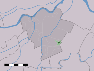
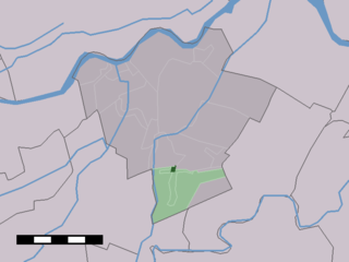
The village centre (dark green) and the statistical district (light green) of Tienhoven in the municipality of Maarssen.
Coordinates: 52°10′9″N5°4′51″E / 52.16917°N 5.08083°E / 52.16917; 5.08083 Coordinates: 52°10′9″N5°4′51″E / 52.16917°N 5.08083°E / 52.16917; 5.08083
Country Netherlands
Province Utrecht
Municipality Stichtse Vecht
Population (2004)
  Total 440
Time zone CET (UTC+1)
  Summer (DST) CEST (UTC+2)

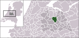
Tienhoven is a village in the Dutch province of Utrecht. It is a part of the municipality of Stichtse Vecht, and lies about 7 km north of Utrecht.

Netherlands Constituent country of the Kingdom of the Netherlands in Europe

The Netherlands is a country located mainly in Northwestern Europe. The European portion of the Netherlands consists of twelve separate provinces that border Germany to the east, Belgium to the south, and the North Sea to the northwest, with maritime borders in the North Sea with Belgium, Germany and the United Kingdom. Including three island territories in the Caribbean Sea—Bonaire, Sint Eustatius and Saba— it forms a constituent country of the Kingdom of the Netherlands. The official language is Dutch, but a secondary official language in the province of Friesland is West Frisian.

Utrecht (province) Province of the Netherlands

Utrecht is a province of the Netherlands. It is located in the centre of the country, bordering the Eemmeer in the north-east, the province of Gelderland in the east and south-east, the province of South Holland in the west and south-west and the province of North Holland in the north-west and north. With an area of approximately 1,400 square kilometres (540 sq mi), it is the smallest of the twelve Dutch provinces. Apart from its eponymous capital, major cities in the province are Amersfoort, Houten, Nieuwegein, Veenendaal, IJsselstein and Zeist.

Stichtse Vecht Municipality in Utrecht, Netherlands

Stichtse Vecht is a municipality of the Netherlands and lies in the northwestern part of the province of Utrecht.

Tienhoven was a separate municipality until 1957, when it was merged with Maarssen. [1]

Maarssen Town and former municipality in Utrecht, Netherlands

Maarssen is a town in the middle of the Netherlands, in the province of Utrecht, along the river Vecht and the Amsterdam–Rhine Canal. The west of Maarssen is called Maarssen-Broek whereas the east is called Maarssen-Dorp. Both put together and joined by other small towns around provide the area of Maarssen.

In 2001, the village of Tienhoven had 158 inhabitants. The built-up area of the village was 0.044 km², and contained 52 residences. [2] The statistical area "Tienhoven", which also can include the peripheral parts of the village, as well as the surrounding countryside, has a population of around 460. [3]

Related Research Articles

Vreeland Village in Utrecht, Netherlands

Vreeland is a village in the Dutch province of Utrecht. It was a part of the former municipality of Loenen. Since 2011 it has been part of the new formed municipality of Stichtse Vecht. It is located on the river Vecht, about 2 km north of Loenen aan de Vecht. It received city rights in 1265. In 2015, the village celebrates the 650th year of its foundation.

Vleuten Neighbourhood of Utrecht in Netherlands

Vleuten is a former village in the Dutch province of Utrecht. It is a neighbourhood of the city of Utrecht, and lies about 6 km west of it. Vleuten has a railway station on the line between Utrecht and Woerden.

Baambrugge Town in Utrecht, Netherlands

Baambrugge is a village on the river Angstel in the Dutch province of Utrecht. It is a part of the municipality of De Ronde Venen and lies about 14 km southeast of Amsterdam. In 2001 the village of Baambrugge had 925 inhabitants. The built-up area of the town was 0.21 km² and contained 365 residences. The statistical area "Baambrugge", which also can include the peripheral parts of the village, as well as the surrounding countryside, has a population of around 1000.

Zegveld Town in Utrecht, Netherlands

Zegveld is a village in the Dutch province of Utrecht. It is a part of the municipality of Woerden and lies about 5 km northwest of Woerden.

Loenersloot Village in Utrecht, Netherlands

Loenersloot is a village in the Dutch province of Utrecht. It was a part of the former municipality of Loenen. Since 2011 it has made part of the new formed municipality of Stichtse Vecht. It lies about 12 km west of Hilversum. It is located on the Angstel River.

Groenekan Village in Utrecht, Netherlands

Groenekan is a village in the Dutch province of Utrecht. It is a part of the municipality of De Bilt, and lies about 3 km west of Bilthoven.

Westbroek Village in Utrecht, Netherlands

Westbroek is a village in the Dutch province of Utrecht. It is a part of the municipality of De Bilt, and lies about 6 km northwest of Bilthoven.

Jaarsveld Town in Utrecht, Netherlands

Jaarsveld is a town in the Dutch province of Utrecht. It is a part of the municipality of Lopik, and lies about 7 km southwest of IJsselstein.

Hekendorp Village in Utrecht, Netherlands

Hekendorp is a village in the Dutch province of Utrecht. It is a part of the municipality of Oudewater, and lies about 6 km east of Gouda.

Kamerik Town in Utrecht, Netherlands

Kamerik is a village in the Dutch province of Utrecht. It is a part of the municipality of Woerden and is situated about 3 km north of Woerden.

Linschoten (village) Town in Utrecht, Netherlands

Linschoten is a village in the Dutch province of Utrecht. It is a part of the municipality of Montfoort, and lies about 3 km southeast of Woerden.

Oud-Zuilen Town in Utrecht, Netherlands

Oud-Zuilen is a town in the Dutch province of Utrecht. It is a part of the municipality of Stichtse Vecht, and lies about 4 km northwest of Utrecht. It is in an area called the "Vechtstreek".

Nieuwer-Ter-Aa Village in Utrecht, Netherlands

Nieuwer-Ter-Aa is a village in the Dutch province of Utrecht (province). It is a part of the municipality of Stichtse Vecht, and lies about 13 km northwest of Utrecht.

Kockengen Village in Utrecht, Netherlands

Kockengen is a village in the Dutch province of Utrecht (province). It is a part of the municipality of Stichtse Vecht, and lies about 9 km northeast of Woerden.

Ameide Place in Utrecht, Netherlands

Ameide is a village in the Dutch province of Utrecht. It is a part of the municipality of Vijfheerenlanden, and lies about 9 km southwest of IJsselstein.

Leerbroek Place in Utrecht, Netherlands

Leerbroek is a village in the Dutch province of Utrecht. It is a part of the municipality of Vijfheerenlanden, and lies about 9 km (6 mi) northeast of Gorinchem.

Lexmond Place in Utrecht, Netherlands

Lexmond is a town in the Dutch province of Utrecht. It is a part of the municipality of Vijfheerenlanden, and lies about 7 km south of IJsselstein.

Nieuwland, Vijfheerenlanden Village in Utrecht, Netherlands

Nieuwland is a village in the Dutch province of Utrecht. It is a part of the municipality of Vijfheerenlanden, and lies about 8 km north of Gorinchem.

Tienhoven aan de Lek Place in Utrecht, Netherlands

Tienhoven is a village in the Dutch province of Utrecht. It is a part of the municipality of Vijfheerenlanden, and lies about 10 km southwest of IJsselstein.

Haaften Village in Gelderland, Netherlands

Haaften is a village in the Dutch province of Gelderland. It is a part of the municipality of Neerijnen, and lies about 25 km south of Utrecht.

References

  1. Ad van der Meer and Onno Boonstra, "Repertorium van Nederlandse gemeenten", KNAW, 2006.
  2. Statistics Netherlands (CBS), Bevolkingskernen in Nederland 2001. (Statistics are for the continuous built-up area).
  3. Statistics Netherlands (CBS), Statline: Kerncijfers wijken en buurten 2003-2005. As of 1 January 2005.