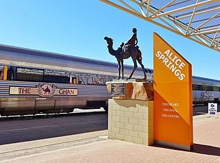
The Ghan is an Australian passenger train service between Adelaide, Alice Springs and Darwin on the Adelaide–Darwin railway. Operated by Great Southern Rail, it takes 54 hours to travel the 2,979 kilometres (1,851 mi) with a four-hour stopover in Alice Springs.
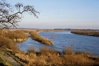
The Bug River is a major river mostly located in Eastern Europe, which flows through three countries with a total length of 774 kilometres (481 mi).

Gitega is the capital and one of the largest cities in Burundi. Located in the centre of the country, in the Burundian central plateau roughly 62 kilometres (39 mi) east by south of Bujumbura, Gitega was the seat of the Kingdom of Burundi until its abolition in 1966. In late December 2018, Burundian president Pierre Nkurunziza announced that he would follow on a 2007 promise to return Gitega its former political capital status, with Bujumbura remaining as economical capital and centre of commerce. A vote in the Parliament of Burundi made the change official on 16 January 2019, with all branches of government expected to move in over three years.

Douz is a town in the Kebili Governorate in the south of Tunisia, known as the "gateway to the Sahara." By road it is located 31 kilometres (19 mi) southwest of Blidet, 125 kilometres (78 mi) southeast of Tozeur, and 475 kilometres (295 mi) south of the Tunisian capital of Tunis.

The Mid West region is one of the nine regions of Western Australia. It is a sparsely populated region extending from the west coast of Western Australia, about 200 kilometres (120 mi) north and south of its administrative centre of Geraldton and inland to 450 kilometres (280 mi) east of Wiluna in the Gibson Desert.

Aryabhatta was India's first satellite, named after the famous Indian astronomer of the same name.

The Tabqa Dam, or al-Thawra Dam as it is also named, most commonly known as Euphrates Dam, is an earthen dam on the Euphrates, located 40 kilometres (25 mi) upstream from the city of Raqqa in Raqqa Governorate, Syria. The city of Al-Thawrah is located immediately south of the dam. The dam is 60 metres (200 ft) high and 4.5 kilometres (2.8 mi) long and is the largest dam in Syria. Its construction led to the creation of Lake Assad, Syria's largest water reservoir. The dam was constructed between 1968 and 1973 with help from the Soviet Union. At the same time, an international effort was made to excavate and document as many archaeological remains as possible in the area of the future lake before they would be flooded by the rising water. When the flow of the Euphrates was reduced in 1974 to fill the lake behind the dam, a dispute broke out between Syria and Iraq that was settled by intervention from Saudi Arabia and the Soviet Union. The dam was originally built to generate hydroelectric power, as well as irrigate lands on both sides of the Euphrates. The dam has not reached its full potential in either of these objectives.

The Ngounié River is a river flowing through southwest-central Gabon. It is the last and second most important tributary of the Ogooué River, the first being the Ivindo River. It initially flows down from the Chaillu Mountains, along the border with Congo, and then turns northwest, flowing through the towns of Fougamou, Sindara and Mouila before flowing into the Ogooué.
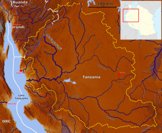
The Malagarasi River is a river found in northwestern Tanzania and one of its tributaries comes from southeastern Burundi, flowing through Kigoma Region. It is the second-longest river in the country(Tanzania), and has the largest watershed of all of the rivers flowing into Lake Tanganyika. The Malagarasi-Muyovozi Wetlands are a designated a Ramsar site. Local tribes have nicknamed the Malagarasi as "the river of bad spirits".

Lahore Metro is an automated rapid transit system under construction in Lahore, Punjab, Pakistan. Three metro lines have been proposed, of which the Orange Line is under construction. When operational in March 2019, it will become Pakistan's first metro line.

The Shire of Kyneton was a local government area about 85 kilometres (53 mi) northwest of Melbourne, the state capital of Victoria, Australia. The shire covered an area of 725.2 square kilometres (280.0 sq mi), and existed from 1859 until 1995.

Apinac is a village and commune in the Loire department in central France. Apinac is in the extreme southwest of the Loire department, 41.7 kilometres (25.9 mi) southwest of Saint-Étienne. The church, dated to the 19th century, is noted for its colorful stained glass windows. Vivaro-Alpine, is the local dialect, which is also spoken in Ardèche or the Southern Alps.

Purple Springs is a hamlet in southern Alberta, Canada within the Municipal District of Taber. It is located on Highway 3, approximately 17 kilometres (11 mi) east of Taber.
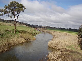
Campbells River, a perennial stream that is part of the Upper Macquarie catchment within the Murray–Darling basin, is located in the central–western region of New South Wales, Australia.

Metline is a commune and town on the Mediterranean coast, in the Bizerte Governorate of northern Tunisia. As of 2004, it had a population of 7,370. It is located approximately 60 kilometres (37 mi) north of Tunis, 28 kilometres (17 mi) southeast of Bizerte and 6 kilometres (3.7 mi) northwest of Ras Jebel. The commune of Metline occupies a peninsula extending between the mountains, the sea and the forest, with a coastline of more than 6 kilometres (3.7 mi). Cape Zebib is 2 kilometres (1.2 mi) to the northeast. The commune was created on May 3, 1967.

The Sofia is a river of northwestern Madagascar. It flows through the Sofia Region. The source is at the Tsaratanana Massif at an altitude of 1784 metres. It has a length of 350 kilometres (220 mi).

Nockatunga Station most commonly known as Nockatunga is a pastoral lease that operates as a cattle station in South West Queensland, Australia.

Bundaleer Station is a pastoral lease that operates as a sheep station in South Australia.
Dalhousie Station most commonly known as Dalhousie Springs Station was a pastoral lease that once operated as a cattle station in South Australia. Dalhousie and other surrounding leases were acquired by the Australian Government in 1985 to make up Witjira National Park.
Myrtle Springs Station is a pastoral lease that operates as a sheep station in outback South Australia.