Dhrangadhra is a town, taluka headquarters and a municipality in Surendranagar district in the state of Gujarat, India. During the period of the British Raj, the city was the capital of Dhrangadhra State, one of the eight first-class princely states of the Kathiawar Agency in the Bombay Presidency.

Baran district is a district in the Indian state of Rajasthan. The headquarters of the district are located at the city of Baran.
Batote is a town and a notified area committee, near Ramban town in Ramban district of Indian union territory of Jammu and Kashmir on NH 44 just beyond Ramban, Patnitop while going towards Srinagar.
Halvad is a town and a municipality in Morbi district in the Gujarat state of India.
Rapar is a city and a municipality in Kutch district (Kachchh) in the Indian state of Gujarat.

Upleta is a city and tehsil in the Rajkot district of the state of Gujarat, India.
Ichoda is a town in Adilabad district in the state of Telangana in India.
Bamanbore is a town in Surendranagar district of Gujarat, India.
Navlakhi Port is an all-weather lighterage non-major intermediate port. It is situated on the southwest end of the Gulf of Kutch in Hansthal Creek, India. The Port is about 45 km from Morbi and 160 km from Kandla. Navigation is permitted only during daylight hours; boats use channel buoys for navigation. The port unloads 8,000 to 9,000 MT of coal per day. It is governed by the Gujarat Maritime Board. The nearest airports are Rajkot (120 km) and Jamnagar (135 km).
Sidi Haneish Airfield is an abandoned World War II military airfield complex in Egypt, in the western desert, about 376 km west-northwest of Cairo.

Aroli is a village of Pappinisseri Panchayat in Kannur district in the Indian state of Kerala.

Amsin is a town and Gram Panchayat in Ayodhya district in the Indian state of Uttar Pradesh, India. Amsin is 43 km away from district headquarters Ayodhya city.

Kingdom of Jhalavad was a kingdom present in the Kathiawar region of Gujarat. The kingdom came to be known as the Dhrangadhra State after it became a princely state in the nineteenth century. The town of Dhrangadhra served as its capital. It was also known as Halvad-Dhrangadhra State. Halvad once had been the capital of this state. It was ruled by the Jhala clan of Rajputs.

Morbi district is in the state of Gujarat, India. It was formed on 15 August 2013, along with several other districts, on the 67th Independence Day of India. Morbi city is the administrative headquarters of the district. The district has 5 talukas - Morbi, Maliya, Tankara, Wankaner and Halvad. Morbi city is the administrative headquarters of Morbi district. The town of Morbi is situated on the Machchhu River, 35 km from the sea and 60 km from Rajkot. As per 2011 census data, the city had a population of 2,10,451 and average literacy rate of 83.64%.
Dhrangadhra is one of the 182 Legislative Assembly constituencies of Gujarat state in India. It is part of Surendranagar district. After 2008 delimitation, erstwhile Halvad assembly seat was merged with this seat.
Rairangpur Airstrip, also known as Dandbose Airstrip, is located 6 km away from Rairangpur city center in Mayurbhanj district, Odisha, India. Rairangpur Airstrip is spread over 61 acres and is under the control of the Works Department of Government of Odisha. The runway is 750 meters long and is periodically maintained by the state government.
Halvad railway station is a railway station in Morbi district, Gujarat, India on the Western line of the Western railway. It serves Halvad town. Halvad railway station is 162 km far away from Ahmedabad Junction. Railway Yard is started at Sukhpar Terminal of Halvad. Three Express and two Superfast trains halt here.
Malaniyad is a village located in the Halvad Taluka of Surendranagar district of Gujarat State, India. Now this village is in the Halvad taluka of Morbi district. of Gujarat state, India. New district is included in new Gujarat map. This village is near Little Rann of Kutch. Total Population of this village is around 3446.

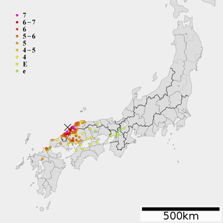
1872 Hamada earthquake was an earthquake that occurred on March 14, 1872, off the coast of Hamada, Shimane Prefecture in Japan. This quake occurred at 16:40 local time.


