Related Research Articles
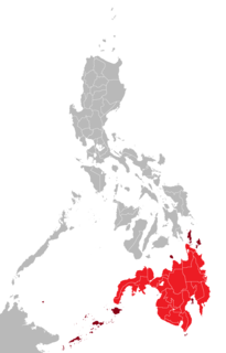
Mindanao is the second-largest island in the Philippines, after Luzon and seventh-most populous island in the world. Located in the southern region of the archipelago, the island is part of an island group of the same name that also includes its adjacent islands, notably the Sulu Archipelago. According to the 2020 census, Mindanao has a population of 26,252,442 people, while the entire island group has an estimated population of 27,021,036 according to the 2021 census.

The Philippines is an archipelago that comprises 7,641 islands with a total land area of 300,000 square kilometers (115,831 sq mi). It is the world's fifth largest island country. The eleven largest islands contain 95% of the total land area. The largest of these islands is Luzon at about 105,000 square kilometers (40,541 sq mi). The next largest island is Mindanao at about 95,000 square kilometers (36,680 sq mi). The archipelago is around 800 kilometers (500 mi) from the Asian mainland and is located between Taiwan and Borneo.

The South China Sea is a marginal sea of the Western Pacific Ocean. It is bounded in the north by the shores of South China, in the west by the Indochinese Peninsula, in the east by the islands of Taiwan and northwestern Philippines, and in the south by Borneo, eastern Sumatra and the Bangka Belitung Islands, encompassing an area of around 3,500,000 km2 (1,400,000 sq mi). It communicates with the East China Sea via the Taiwan Strait, the Philippine Sea via the Luzon Strait, the Sulu Sea via the straits around Palawan, the Strait of Malacca via the Strait of Singapore, and the Java Sea via the Karimata and Bangka Strait. The Gulf of Thailand and the Gulf of Tonkin are also part of the South China Sea. The shallow waters south of the Riau Islands are also known as the Natuna Sea.

The Philippine Sea is a marginal sea of the Western Pacific Ocean east of the Philippine archipelago, the largest in the world, occupying an estimated surface area of 5 million square kilometers. The Philippine Sea Plate forms the floor of the sea. Its western border is the first island chain to the west, comprising the Ryukyu Islands in the northwest and Taiwan in the west. Its southwestern border comprises the Philippine islands of Luzon, Catanduanes, Samar, Leyte, and Mindanao. Its northern border comprises the Japanese islands of Honshu, Shikoku and Kyūshū. Its eastern border is the second island chain to the west, comprising the Bonin Islands and Iwo Jima in the northeast, the Mariana Islands in the due east, and Halmahera, Palau, Yap and Ulithi in the southeast. Its southern border is Indonesia's Morotai Island.

The Sulu Sea is a body of water in the southwestern area of the Philippines, separated from the South China Sea in the northwest by Palawan and from the Celebes Sea in the southeast by the Sulu Archipelago. Borneo is found to the southwest and Visayas to the northeast.
Panguil Bay is an arm of Iligan Bay in Mindanao, Philippines. The bay forms the natural boundary separating the Zamboanga Peninsula from the rest of the island of Mindanao. It borders the provinces of Misamis Occidental, Zamboanga del Sur, and Lanao del Norte. Important cities and municipalities on its coast are Ozamiz and Tangub in Misamis Occidental, and Tubod, the capital of Lanao del Norte.

The Celebes Sea of the western Pacific Ocean is bordered on the north by the Sulu Archipelago and Sulu Sea and Mindanao Island of the Philippines, on the east by the Sangihe Islands chain, on the south by Sulawesi's Minahasa Peninsula, and on the west by northern Kalimantan in Indonesia. It extends 420 miles (675 km) north-south by 520 mi (840 km) east-west and has a total surface area of 110,000 square miles (280,000 km2), to a maximum depth of 20,300 feet (6,200 m). South of the Cape Mangkalihat, the sea opens southwest through the Makassar Strait into the Java Sea.

The Savu Sea is a small sea within Indonesia named for the island of Savu (Sawu) on its southern boundary. It is bounded by Savu and Rai Jua to the south, the islands of Rote and Timor to the east, Flores and the Alor archipelago to the north/northwest, and the island of Sumba to the west/northwest. Between these islands, it flows into the Indian Ocean to the south and west, the Flores Sea to the north, and the Banda Sea to the northeast.

Turtle Islands, officially the Municipality of Turtle Islands, is a 5th class municipality in the province of Tawi-Tawi, Philippines. According to the 2020 census, it has a population of 5,683 people.

The Molucca Sea is located in the western Pacific Ocean, around the vicinity of Indonesia, specifically bordered by the Indonesian Islands of Celebes (Sulawesi) to the west, Halmahera to the east, and the Sula Islands to the south. The Molucca Sea has a total surface area of 77,000 square miles. The Molucca Sea is rich in coral and has many diving sites due to the deepness of its waters. The deepness of the water explains the reasoning behind dividing the sea into three zones, which functions to transport water from the Pacific Ocean to the shallower seas surrounding it. The deepest hollow in the Molucca Sea is the 15,780-foot (4,810-meter) Batjan basin. This region is known for its periodic experiences of earthquakes, which stems from the sea itself being a micro plate, in which the Molucca Sea is being subducted in two opposite directions: one in the direction of the Eurasian Plate to the west and the other in the direction of the Philippines Sea Plate to the east.

Mount Matutum is an active stratovolcano, is the highest point in the province of South Cotabato in the Philippines, with an elevation of 7,500 feet above sea level, approximately 5.7 kilometres (3.5 mi) from Acmonan, Tupi, South Cotabato. Matutum and its foothills are predominantly inhabited by indigenous Blaan families.

The Davao River is the third largest river by drainage basin on the southern Philippines in the island of Mindanao. It drains an area of over 1,700 square kilometres (660 sq mi) with a total length of 170 kilometres (110 mi). Most of the area is uplands. Average flows within the river near to the mouth are estimated at 70 to 80 cubic metres per second. The climate type is relatively uniform throughout the year with evenly distributed rainfall and temperatures and humidity. The area rarely experiences typhoons.

There have been at least four lighthouses named Chennai Lighthouse or Madras Lighthouse, which face the Bay of Bengal on the east coast of the Indian Subcontinent in Chennai, India.
This is a list of points in the Philippines that are farther north, south, east, or west than any other location in the country. Also included are extreme points in elevation, extreme distances, and other points of geographic interest.
The Galle Lighthouse is an onshore Lighthouse in Galle, Sri Lanka and is operated and maintained by the Sri Lanka Ports Authority. This is Sri Lanka's oldest light station.
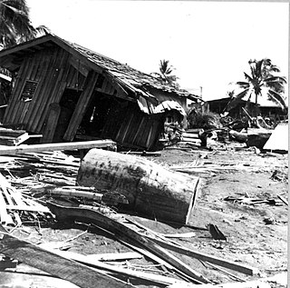
The 1976 Moro Gulf earthquake and tsunami took place on August 17, 1976, at 00:11 local time near the islands of Mindanao and Sulu, in the Philippines. Its magnitude was calculated as being as high as 8.0 on the moment magnitude scale.
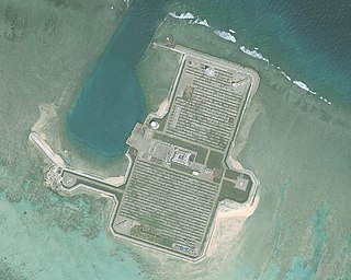
Cuarteron Reef, also known in Mandarin Chinese: 華陽礁/华阳礁; pinyin: Huáyáng Jiāo; Vietnamese: Đá Châu Viên; Malay: Terumbu Calderon; Calderon Reef, is a reef at the east end of the London Reefs in the Spratly Islands of the South China Sea. It is occupied and controlled by China (PRC), and also claimed by the Philippines, by Vietnam and Taiwan (ROC). The reef is 3 nautical miles long and has an area of 8 square kilometres (3.1 sq mi).

Hammer Odde Lighthouse is located on the northernmost point of Hammeren, just outside Sandvig on the Danish island of Bornholm. A sand and gravel ocean bank, named David Bank, is situated 5.25 miles (8.45 km) from the lighthouse.
References
- ↑ "Tinaca Point". www.geonames.org. GeoNames.org. Retrieved 17 February 2017.
- ↑ "Limits of Oceans and Seas" (PDF). Special Publication No. 23, 3rd Edition. Monaco: International Hydrographic Bureau. 1953.
- ↑ Rowlett, Russ (November 10, 2016). "Lighthouses of the Philippines: Southern Mindanao". The Lighthouse Directory. University of North Carolina at Chapel Hill . Retrieved 17 February 2017.
Coordinates: 5°33′22″N125°19′41″E / 5.55611°N 125.32806°E
| | This article about a location in Davao Region is a stub. You can help Wikipedia by expanding it. |