
A thing was a governing assembly in early Germanic society, made up of the free people of the community presided over by a lawspeaker. Things took place at regular intervals, usually at prominent places that were accessible by travel. They provided legislative functions, as well as being social events and opportunities for trade. In modern usage, the meaning of this word in English and other languages has shifted to mean not just an assemblage of some sort but simply an object of any sort.

Long Meg and Her Daughters is a Neolithic stone circle situated north of Penrith in Cumbria, North West England. One of around 1,300 stone circles in the British Isles and Brittany, it was constructed as a part of a megalithic tradition that emerged during Neolithic, and continued into the Early Bronze Age. The stone circle is the third widest in England, behind Avebury in Wiltshire, and only slightly smaller than Stanton Drew in Somerset.

The Wrynose Pass is a mountain pass in the Lake District National Park in Cumbria, England between the Duddon Valley and Little Langdale.
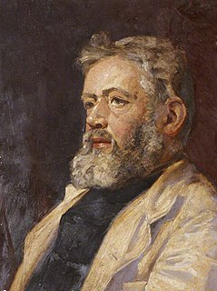
William Gershom Collingwood was an English author, artist, antiquary and professor of Fine Arts at University College, Reading. A long-term resident of Coniston, Cumbria, he was President of the Cumberland and Westmorland Antiquarian Society and the Lake Artists' Society.
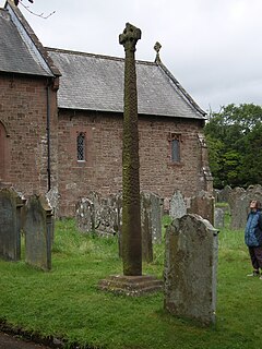
The Gosforth Cross is a large stone Anglo-Saxon cross, in St Mary's churchyard at Gosforth in the English county of Cumbria, dating to the first half of the 10th century AD. Formerly part of the kingdom of Northumbria, the area was settled by Scandinavians some time in either the 9th or 10th century. It has gained reputation for its combination of Christian symbols with Nordic symbols, being a tangible piece of evidence of the impact of the Christianization of Scandinavia.

The Barony of Kendal is a subdivision of the English historic county of Westmorland. It is one of two ancient baronies that make up the county, the other being the Barony of Westmorland. In 1974, the entire county became part of the modern county of Cumbria and ceased to have an administrative function. At the same time, Kendal borough along with some other rural and urban districts in Westmorland was merged with the neighbouring parts of Lancashire, Furness and Cartmel, and also the Sedbergh Rural District of the West Riding of Yorkshire into the new South Lakeland district of the new county.
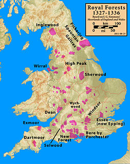
Inglewood Forest is a large tract of mainly arable and dairy farm land with a few small woodland areas between Carlisle and Penrith in the English non-metropolitan county of Cumbria or ancient county of Cumberland.

Dunmail Raise is the name of a large cairn in the English Lake District, which may have been an old boundary marker. It has given its name to the mountain pass of Dunmail Raise, on which it stands. This mountain pass forms part of the only low-level route through the mountains between the northern and southern sides of the Lake District. According to local tradition, the cairn marked the burial of a king named Dunmail who was slain by Saxons. The place name itself may well be derived from the name of the historical Dyfnwal ab Owain, King of Strathclyde.

The history of Cumbria as a county of England begins with the Local Government Act 1972. Its territory and constituent parts however have a long history under various other administrative and historic units of governance. Cumbria is an upland, coastal and rural area, with a history of invasions, migration and settlement, as well as battles and skirmishes between the English and the Scots.

Burton in Lonsdale Castle was in the village of Burton in Lonsdale in North Yorkshire, England.

Stainmore is a remote geographic area in the Pennines on the border of Cumbria, County Durham and North Yorkshire. The name is used for a civil parish in the Eden District of Cumbria, England, including the villages of North Stainmore and South Stainmore. The parish had a population of 253 in the 2001 census, increasing to 264 at the Census 2011. Stainmore Forest stretches further east into County Durham, towards Bowes.
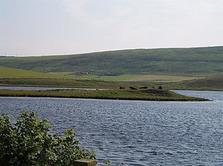
Law Ting Holm is a small promontory at the north end of the freshwater Loch of Tingwall, Mainland Shetland, Scotland. It was once an islet entirely surrounded by water, joined to the shore by a stone causeway 1.7 metres (6 ft) wide and 42.7 metres (140 ft) long. In the 1850s the levels of the loch were lowered and the holm evolved to its present form. The Loch of Tingwall is west of the town of Lerwick and has one additional island - Holm of Setter.

Little Langdale is a valley in the Lake District, England, containing Little Langdale Tarn and a hamlet also called Little Langdale. A second tarn, Blea Tarn, is in a hanging valley between Little Langdale and the larger Great Langdale to the north. Little Langdale is flanked on the south and southwest by Wetherlam and Swirl How, and to the north and northwest by Lingmoor Fell and Pike of Blisco. The valley descends to join with Great Langdale above Elter Water.

The Rev. William Slater Calverley (1847–1898) was an unassuming rural English vicar who through diligent study and painstaking scrutiny became an extraordinary amateur antiquarian. Although born in Leicestershire, Calverley claimed his fame through interpreting the carved sculptured relics that he and others found in Cumberland churchyards. He made intricate drawings, corresponded with academic authorities, and gave his own interpretations, which he then relayed to a wider audience. Calverley later produced in intricate detail a life-sized reproduction of the famous Gosforth Cross, which now stands in Aspatria churchyard.
The history of medieval Cumbria has several points of interest. The region's status as a borderland coping with 400 years of warfare is one. The attitude of the English central government, at once uninterested and deeply interested, is another. As a border region, of geopolitical importance, Cumbria changed hands between the Angles, Norse, Strathclyde Brythons, Picts, Normans, Scots and English; and the emergence of the modern county is also worthy of study.

Milecastle 50TW was a milecastle on the Turf Wall section of Hadrian's Wall. The milecastle is located close to the Birdoswald Roman Fort and is unique in that it was not replaced by a stone milecastle when the turf wall was upgraded to stone, the replacement wall instead running some 200m to the north. The milecastle was partially demolished by the Romans after it was abandoned. The milecastle was excavated in 1934 and several Roman rubbish pits discovered. The remains of the two turrets associated with this milecastle have also been located. As the turf wall lies some distance from the stone wall, the sites are not accessible from the Hadrian's Wall Path.
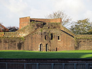
Carlisle city walls were a defensive structure surrounding the centre of Carlisle, Cumbria. The city walls ran from Carlisle Castle in the north-west of the city to The Citadel in the south-east. Between these points, the city was protected by the former North and East Walls and the West Walls which remain largely intact. The line of the walls can still be followed with the exception of the southernmost end of the West Wall which has been built over. The perimeter, including the castle, is approximately 2.2 kilometres (1.4 mi) which is comparable to Southampton town walls but less than Chester city walls.

Beacon Hill, also known as Harting Beacon, is a hillfort on the South Downs, in the county of West Sussex in southern England. The hillfort is located in the parish of Elsted and Treyford, in Chichester District. It is a Scheduled Ancient Monument with a list entry identification number of 1015915. The hilltop enclosure is dated to the Late Bronze Age, from the 8th to 6th centuries BC. The hillfort defences were renewed during the Late Iron Age.

Greenholme is a hamlet in Cumbria, England.
Kaup is a hill on the bank of the Curonian Lagoon, immediately north of the village of Mokhovoye, Kaliningrad Oblast, Russia. It is a large early medieval burial site with Norse grave goods. Kaup has been viewed by historians as an important early medieval emporium and a likely starting point of the Amber Road to the south. The original name of this medieval settlement is uncertain.
