
The National Trails System is a series of trails in the United States designated "to promote the preservation of, public access to, travel within, and enjoyment and appreciation of the open-air, outdoor areas and historic resources of the Nation". There are four types of trails: the national scenic trails, national historic trails, national recreation trails, and connecting or side trails. The national trails provide opportunities for hiking and historic education, as well as horseback riding, biking, camping, scenic driving, water sports, and other activities. The National Trails System consists of 11 national scenic trails, 21 national historic trails, over 1,300 national recreation trails, and seven connecting and side trails, as well as one national geologic trail, with a total length of more than 91,000 mi (150,000 km). The scenic and historic trails are in every state, and Virginia and Wyoming have the most running through them, with six.

Żabbar, also known as Città Hompesch, is a city in the South Eastern Region of Malta. It is the seventh largest city in the country, with an estimated population of 15,648 as of January 2021. Originally a part of Żejtun, Żabbar was granted the title of Città Hompesch by the last of the Grand Masters of the Order of St. John to reign in Malta, Ferdinand von Hompesch zu Bolheim.

Old Ottawa East or just Ottawa East is a neighbourhood in Capital Ward in central Ottawa, Ontario, Canada. It is located south of Nicholas Street and between the Rideau Canal and the Rideau River, with Avenue Road marking the southern border. To the south is the neighbourhood of Old Ottawa South and to the northeast is Sandy Hill. Old Ottawa East includes the Lees Avenue area. The Flora Footbridge, which opened to pedestrians in 2019, connects the community to The Glebe.

Whitburn is a village and former civil parish, now in the unparished area of Boldon, in the South Tyneside district, in the metropolitan county of Tyne and Wear on the coast of North East England. It is located 3 miles (4.8 km) north of the city of Sunderland and 4 miles (6.4 km) south of the town of South Shields. Historically, Whitburn was a part of County Durham. Other nearby population centres include Seaburn, Cleadon and Marsden. The village lies on a south-facing slope, part of Durham's Magnesian Limestone plateau, which overlooks Sunderland. The population for the combined Whitburn and Marsden Ward in the 2011 UK Census was 7,448. For much of its history, Whitburn was a fishing and agricultural community. The village contains three schools, three churches, cricket club, recreational grounds, a pub and a variety of shops.

Gorebridge is a former mining village in Midlothian, Scotland.
Wrekenton is a residential area in Gateshead, located around 3.5 miles (5.6 km) from Newcastle upon Tyne, 11 miles (18 km) from Sunderland, and 14 miles (23 km) from Durham. In 2011, Census data for the Gateshead Metropolitan Borough Council ward of High Fell recorded a total population of 6,110.

The Frederick Gunn School is a private, coeducational, boarding and day prep school for students in grades 9-12 and postgraduate, located in rural Connecticut, United States. The 220-acre (0.89 km2) campus borders the village green of Washington, a small, historic town in Litchfield Hills. Formerly known as The Gunnery and Mr. Gunn's School, it was named for its founder, has no military affiliations and is a non-sectarian school.
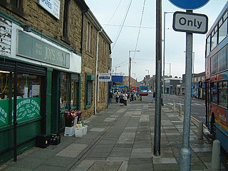
Forest Hall is a village in the borough of North Tyneside, Tyne and Wear, England. It is 4 miles from Newcastle upon Tyne. It borders Killingworth to the north, Holystone to the east and Benton to the south. The village has seen a slight increase in antisocial behaviour in recent years.
Koligudda is a village in the Raybag Taluk of the Belgaum district in Karnataka, India. It is situated 123 kilometers northeast of Belgaum, between the Athani-Gokak road.

Saraila is a village in Kamsaar in the Indian state of Uttar Pradesh.Saraila is a village in Zamania Tehsil in Ghazipur District of Uttar Pradesh, India. It belongs to Varanasi Division. It is located 30 km to the south of District headquarters Ghazipur. 11 km from Bhadauraa. 372 km from State capital Lucknow. The village was also a part of Daudpur Estate which had its capital at Dewaitha.

Jaburna is a village in Kamsaar in the Indian state of Uttar Pradesh.

Ghehi is a village in Emamzadeh Abdol Aziz Rural District, Jolgeh District in Isfahan County, Isfahan Province, Iran. At the 2006 census, its population was 768, in 200 families.

Miss Universe 2018 was the 67th Miss Universe pageant, held at the IMPACT Arena, Muang Thong Thani, Nonthaburi Province, Thailand on December 17, 2018.
The 2019 J1 League, also known as the 2019 Meiji Yasuda J1 League for sponsorship reasons, was the 27th season of the J1 League – the top Japanese professional league for association football clubs since its establishment in 1993.

Purani Mosque of Dewaitha was built by Sarkar Dewan Raja Daud Khan Zamindar in 1606 at Dewaitha village. Jama Masjid of Dewaitha is one of the oldest historic monuments in Ghazipur district.
Raipur, also known as Baksot, is a village in Ghazipur district of Uttar Pradesh, India. It was a part of Daudpur and was also known as Nizampur.
Dewaitha is a village in Dildarnagar Kamsar, Ghazipur, India, on the banks of the Karmanasa River. The village had a population of 7,706 as of the 2011 Census of India and a land area of 1,043 acres. Most of the people living in the village are Kamsar Pathan.
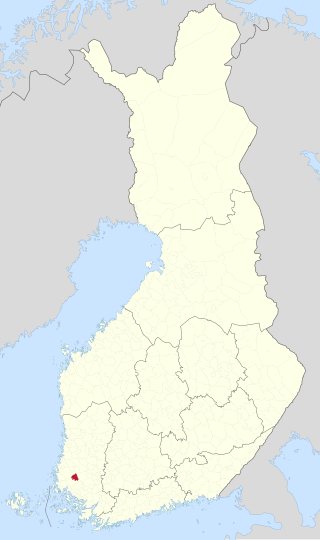
Karjala is a former municipality of Finland in the former Turku and Pori Province, now in Finland Proper. It was consolidated with Mynämäki in 1977.
