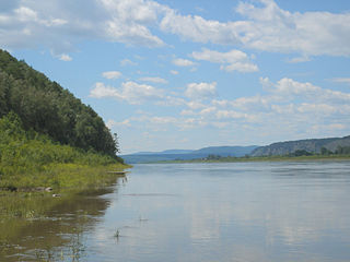
The Amur River or Heilong Jiang is the world's tenth longest river, forming the border between the Russian Far East and Northeastern China. The largest fish species in the Amur is the kaluga, attaining a length as great as 5.6 metres (18 ft). The river basin is home to a variety of large predatory fish such as northern snakehead, Amur pike, taimen, Amur catfish, predatory carp and yellowcheek, as well as the northernmost populations of the Amur softshell turtle and Indian lotus.

Amur Oblast is a federal subject of Russia, located on the banks of the Amur and Zeya Rivers in the Russian Far East. The administrative center of the oblast, the city of Blagoveshchensk, is one of the oldest settlements in the Russian Far East, founded in 1856. It is a traditional center of trade and gold mining. The territory is accessed by two railways: the Trans-Siberian Railway and the Baikal–Amur Mainline. As of the 2010 Census, the oblast's population was 830,103.
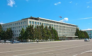
Blagoveshchensk is a city and the administrative center of Amur Oblast, Russia, located at the confluence of the Amur and Zeya Rivers, opposite to the Chinese city of Heihe. Population: 214,390 (2010 Census); 219,221 (2002 Census); 205,553 (1989 Census).
The Bureya River is a 623-kilometre (387 mi) long south-flowing tributary of the Amur River. Its name comes from the Evenk word birija, meaning river. It is formed from the junction of the Pravaya (right) Bureya and the Levaya (left) Bureya.

Tynda is a town in Amur Oblast, Russia, located 568 kilometers (353 mi) northwest of Blagoveshchensk. It is an important railway junction, informally referred to as the capital of the Baikal-Amur Mainline. Its population has declined sharply in recent years: 36,275 (2010 Census); 40,094 (2002 Census); 61,996 (1989 Census).
Selemdzha River is a river in the Amur Region of Russia. It is the biggest tributary of the Zeya River. The length of the river is 647 km. The area of its basin 68,600 km². Its main tributaries are the Ulma and Nora. The Selemdzha River freezes up in early November and stays under the ice until early May. It begins not far from Uda Gulf on the Pacific and flows southwest, crossing the Baikal Amur Mainline just west of Fevralsk and reaches the Zeya north of the Trans-Siberian Railway and Blagoveshchensk.
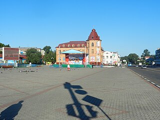
Belogorsk is a town in Amur Oblast, Russia, located on the Tom River, a tributary of the Zeya. Population: 68,249 (2010 Census); 67,422 (2002 Census); 73,435 (1989 Census); 53,000 (1969); 34,000 (1939).
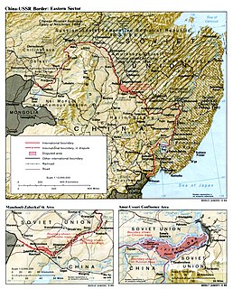
The Sixty-Four Villages East of the River were a group of Manchu-inhabited villages located on the left (north) bank of the Amur River opposite to Heihe, and on the east bank of Zeya River opposite to Blagoveshchensk. Their area totalled 3,600 square kilometres (1,400 sq mi).
Novopetrovka is a village (selo) in Blagoveshchensky District of Amur Oblast, Russia, located on the west bank of the Zeya River. Population: 916. Elevation: 456 feet (139 m).
Gilyuy is a river in Amur Oblast, Russia. It is a right tributary of the Zeya River, and is 545 km long, with a drainage basin of 22,500 km². The river has its sources on the southern slopes of the Stanovoy Mountains, passes near Tynda and flows southeast into the Zeya Reservoir.
Toms River is a freshwater river and estuary in New Jersey

The Huma River is a right tributary on the northern loop of the Amur River in China's province of Heilongjiang. It starts in the Greater Khingan Mountains and flows in a general eastern and south-eastern direction, parallel and southwest of the Amur, until falling into the Amur in Huma County, at 51.617°N 126.697°E, about 10 kilometres (6 mi) south of Huma County's county seat.
The Dep River is a tributary of the Zeya River in eastern Russia.

Magdagachinsky District is an administrative and municipal district (raion), one of the twenty in Amur Oblast, Russia. The area of the district is 16,667 square kilometers (6,435 sq mi). Its administrative center is the urban locality of Magdagachi. Population: 22,671 (2010 Census); 26,427 ; 33,682 (1989 Census). The population of Magdagachi accounts for 48.1% of the district's total population.

Zeya is a town in Amur Oblast, Russia, located on the Zeya River 230 kilometers (140 mi) southeast of Tynda and 532 kilometers (331 mi) north of Blagoveshchensk. Population: 24,986 (2010 Census); 27,795 (2002 Census); 31,955 (1989 Census).
Bolshaya Pyora is a river in Amur Oblast, Russia. It is a right tributary of the Zeya River. Begins on the Amur–Zeya Plain northwest of the mountains it flows through the town of Shimanovsk and the Vostochny Cosmodrome. Flows into the duct peroxide Zeya River above Svobodny and has a length of 145 km Columbine 4400 km. Its main tributaries are Dzhatva (57 km) and Malaya Pyora (88 km) to the right and Ora (55 km) to the left.
Amur–Zeya Plain is plateau in Amur Oblast, Russia, located on the left bank of the middle reaches of the Amur River, between the Amur and Zeya river.
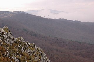
Zeya Nature Reserve is a Russian 'zapovednik' located over the mountainous headwaters of the Zeya River, on the eastern end of the Tukuringra Ridge in the Amur Region of the Russian Far East. It was created in part to serve as a "reference plot" for the study of the ecological impact of the Zeya Dam and the Zeya Reservoir which were built in the 1960s and 1970s. The ground cover in the reserve is primarily taiga, of mostly larch and Mongolian oak. The reserve is situated 13 km north of the city of Zeya, in the Zeysky District of Amur Oblast.


