Related Research Articles

Vigor Shipyards is the current entity operating the former Todd Shipyards after its acquisition in 2011. Todd Shipyards was founded in 1916, which owned and operated shipyards on the West Coast of the United States, East Coast of the United States and the Gulf. Todd Shipyards were a major part of the Emergency Shipbuilding Program for World War II.

The Cariboo is an intermontane region of British Columbia, Canada, centered on a plateau stretching from Fraser Canyon to the Cariboo Mountains. The name is a reference to the caribou that were once abundant in the region.

Clear Creek is a tributary of the upper Sacramento River in northern California.

Mountain View High School (MVHS) is located at 3535 Truman Avenue, Mountain View, California, 94040. It is one of two Mountain View-Los Altos Union High School District public high schools - the other being Los Altos High School. The three main feeder schools are Graham Middle School, Crittenden Middle School, and Blach Intermediate School.

State Route 122 is a primary state highway in the U.S. state of Virginia. The state highway runs 54.58 miles (87.84 km) from SR 40 in Rocky Mount north to U.S. Route 501 in Big Island. SR 122 passes through the Blue Ridge foothills of Franklin and Bedford counties, connecting Rocky Mount with the town of Bedford. The state highway provides access to Booker T. Washington National Monument and Smith Mountain Lake, and the National D-Day Memorial via its Bedford business route.
The Williams Lake First Nation is a First Nations government of the Secwepemc (Shuswap) Nation, located in the Cariboo region of the Central Interior region of the Canadian province of British Columbia, at the city of Williams Lake. It was created when the government of the then-Colony of British Columbia established an Indian reserve system in the 1860s. It is a member government of the Northern Shuswap Tribal Council. Its main Indian Reserve is Williams Lake Indian Reserve No. 1, a.k.a. "Sugarcane" or "The Cane" or "SCB".

The Millsmont neighborhood located in the foothills of Oakland, California encompasses the area of East Oakland to the south and east of Mills College. Seminary Avenue is considered the northern border, and Edwards Avenue the approximate southern border; MacArthur Boulevard bounds it to the west, and Interstate 580 to the east. It lies at an elevation of 239 feet.
The Raccoon Strait is a waterway of the San Francisco Bay between Angel Island and the Tiburon Peninsula, mainland Marin County, California, United States. During the ice ages, when sea levels were considerably lower and San Francisco Bay was a grassy valley, the combined Sacramento-San Joaquin river flowed through what is now Raccoon Strait before flowing through the canyon at the Golden Gate.
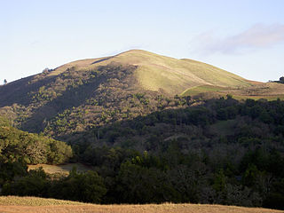
Bald Mountain is a name given to over fifty summits in California.

The Coburg Hills are a range of foothills of the western Cascade Range of Lane and Linn counties in the U.S. state of Oregon. They are located northeast of Eugene and east of Coburg, between the Mohawk Valley and Willamette Valley.
McGillivray Pass is a mountain pass in the Pacific Ranges of southwestern British Columbia, Canada, located about 30 miles west of the town of Lillooet and immediately west of the upper end of Anderson Lake, above the former resort community of McGillivray. The pass connects the head of McGillivray Creek with the head of Standard Creek, a tributary of Cadwallader Creek and was used as a route by prospectors, miners and hunters heading for the upper Bridge River Country beyond the pass. The pass was proposed at one time for a cog railway to connect the mines at Bralorne and Pioneer with the Pacific Great Eastern Railway (now part of CN but the project never went forward. There are private ski cabins near the summit area of the pass, which is the division between the Bendor Range to the east and the Cadwallader Range to the west.
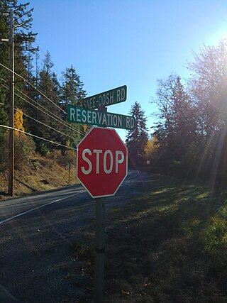
Snee Oosh is a populated place on Fidalgo Island in the U.S. state of Washington, on the Swinomish Indian Reservation. The population was reported as 302 in 1999.

Kelley Point Park is a city park in north Portland in the U.S. state of Oregon. Bounded by the Columbia Slough on the south, the Willamette River on the west, and the Columbia River on the north, the park forms the tip of the peninsula at the confluence of the rivers. Marine Terminal 6 of the Port of Portland lies immediately east of the park along the Columbia, while Terminal 5 is along the Willamette slightly south of the Columbia Slough. The park is at 45.6498384°N 122.7637106°W and rises to an elevation of 39 feet (12 m) above sea level. Sauvie Island is west of the park across the Willamette River. Hayden Island is slightly upstream of the park on the Columbia River opposite Marine Terminal 6.

The City Club of Portland is a nonprofit, nonpartisan civic organization based in Portland in the U.S. state of Oregon. Established in 1916, the organization had approximately 1500 members and a paid staff of 4 in 2013. The former Mayor of Portland, Sam Adams, served as executive director 2013 to 2015. The current executive director is Julia Meier.
Wedge Pass, also known as Billygoat Pass, 1430 m (4692 ft), is a mountain pass in the northern Garibaldi Ranges, the southwesternmost subdivisions of the Pacific Ranges of the Coast Mountains in British Columbia, Canada. Located immediately on the southern flank of Wedge Mountain and to the immediate north of the Spearhead Range, site of the Blackcomb half of the Whistler Blackcomb Ski Area, it connects the head of Wedge Creek (W), a tributary of the Green River with those of Billgoat Creek (E), a tributary of the Lillooet River. The pass is within Garibaldi Provincial Park and has no road access.

Mountain Creek is a 20.9-mile-long (33.6 km) tributary of Yellow Breeches Creek in Cumberland County, Pennsylvania.
Mollie's Nipple or Molly's Nipple is the name given to as many as seven peaks, at least one butte, at least one well, and some other geological features in Utah. Some sources claim there are eleven geological features in Utah that bear this name. At least some of those names are attributed to John Kitchen – a pioneer of an early exploration of Utah, who named them to commemorate a nipple of his wife Molly.
Mountain View is an unincorporated community in Whatcom County, in the U.S. state of Washington.
References
- 1 2 3 U.S. Geological Survey Geographic Names Information System: Tomhead Mountain
- ↑ "Place Names" (PDF). Tehama County Department of Education. p. 55. Archived from the original on 8 May 2017. Retrieved 25 March 2018.
{{cite web}}: CS1 maint: bot: original URL status unknown (link)
40°08′10″N122°49′04″W / 40.1359856°N 122.8177884°W
| | This Tehama County, California-related article is a stub. You can help Wikipedia by expanding it. |