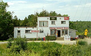
Wanup is a dispersed rural community and unincorporated place in the geographic township of Dill in the southeast of the city of Greater Sudbury, Ontario, Canada. Wanup became part of Greater Sudbury on January 1, 2001, when that city was created by amalgamating the former Regional Municipality of Sudbury, to which the townships of Dill and Cleland were added.

Lac-Sainte-Thérèse is a dispersed rural community in geographic Casgrain Township, Cochrane District in Northeastern Ontario, Canada. The community is counted as part of Unorganized Cochrane North Part in Canadian census data.
Speckled Trout Creek is a creek in geographic Labonte Township, Algoma District in Northeastern Ontario, Canada. It is almost entirely in Lake Superior Provincial Park, is in the Great Lakes Basin, and empties into Lake Superior.
Sturgeon Lake is a lake located 2.0 km (1.2 mi) south of Tomiko and 8.0 km (5.0 mi) north-east of Highway 11 / Trans-Canada Highway in the Nipissing District of northeastern Ontario, Canada. It is in geographic Stewart Township and is part of the Great Lakes Basin.

Coppell is a dispersed rural community and unincorporated place in geographic Lowther Township, Cochrane District in Northeastern Ontario, Canada. It is about 22 kilometres (14 mi) southwest of Hearst, and is counted as part of Unorganized Cochrane North Part in Canadian census data.
Mead is a Dispersed Rural Community and unincorporated place in geographic Lowther Township, Cochrane District in Northeastern Ontario, Canada. The community is counted as part of Unorganized Cochrane North Part in Canadian census data, and is located just north of the border with Algoma District.

Hurkett is a dispersed rural community and unincorporated place in the Unorganized part of Thunder Bay District in northwestern Ontario, Canada. It is on Black Bay on the north shore of Lake Superior in geographic Stirling Township, and is on Ontario Highway 582, a short spur off Ontario Highway 17. Hurkett is a designated place served by a local services board, and has a population of 236.
Gardiner is a Dispersed Rural Community and unincorporated place in geographic Blount Township, Cochrane District, Ontario, Canada. It is approximately 30 kilometres (19 mi) north of the town of Cochrane, and is the northern terminus of Ontario Highway 579. The community is also astride the Ontario Northland Railway line from Cochrane to Moosonee, but is not served by Polar Bear Express passenger trains.
Clute is a Dispersed Rural Community and unincorporated place in the town of Cochrane, in Cochrane District, Ontario, Canada. It is also the name of a geographic township in Cochrane District, at the northeastern corner of which the community lies. An irregularly-shaped eastern part of the geographic township lies in the town of Cochrane following an amalgamation after 1996; the rest, the majority of the township, lies in the Unorganized North Part of Cochrane District.
Otter is a dispersed rural community and unincorporated place in geographic Gooderham Township, Nipissing District, Northeastern Ontario, Canada. It was created during the construction of the Ontario Northland Railway in the early 20th century. Otter is located on the railway line between the railway points of Bushnell to the north and Diver to the south. Otter Lake to the west takes its name from the dispersed rural community of Otter.
Minnipuka is an unincorporated place and Dispersed Rural Community in geographic Marjorie Township, in the Unorganized North part of Algoma District in northeastern Ontario, Canada. It is on the Canadian National Railway transcontinental railway main line between the railway points of Neswabin to the west and Dishnish to the east, has a passing track, and is passed but not served by Via Rail transcontinental Canadian passenger trains. The place is on the east side of Minnipuka Lake, part of the Goat River system.
Mulock is a dispersed rural community and unincorporated place in geographic Mulock Township, Nipissing District in Northeastern Ontario, Canada, named for William Mulock. It was created during the construction of the Ontario Northland Railway in the early 20th century. Mulock is located between the dispersed rural communities of Tomiko to the north and the Feronia to the south, and has a passing siding.
Mulock Township is a geographic township in the Unorganized North Part of Nipissing District in Northeastern Ontario, Canada, named for William Mulock. The Ontario Northland Railway, constructed in the early 20th century, runs through the southwestern tip of the township; the dispersed rural community of Mulock with a passing siding is located on the railway.
Mulock is a dispersed rural community and unincorporated place in the municipality of West Grey, Grey County in Southwestern Ontario, Canada, named for William Mulock.
Ferguson Lake is a lake in the geographic Stewart Township, Nipissing District in Northeastern Ontario, Canada. It is part of the Saint Lawrence River drainage basin.
Stewart Township is a geographic township in the Unorganized North Part of Nipissing District in Northeastern Ontario, Canada. The Ontario Northland Railway, constructed in the early 20th century, runs from south to north through the township, and the dispersed rural community of Tomiko with two passing sidings is on the railway in the centre-east.
The Jocko River is a river in Nipissing District in Northeastern Ontario, Canada. It is in the Saint Lawrence River drainage basin, is a right tributary of the Ottawa River, and lies entirely within Jocko Rivers Provincial Park.
Jocko is a dispersed rural community and unincorporated place in geographic Osborne Township in the Unorganized North Part of Nipissing District in Northeastern Ontario, Canada. It was created during the construction of the Ontario Northland Railway in the early 20th century. Jocko is located on the railway line between the railway point of Osborne to the north and the dispersed rural community of Tomiko to the south.
Osborne Township is a geographic township in the Unorganized North Part of Nipissing District in Northeastern Ontario, Canada. The Ontario Northland Railway, constructed in the early 20th century, runs from the middle south to the northwest of the township. The dispersed rural community of Jocko, without any passing sidings, and the railway point of Osborne, with one passing siding, are at the middle south and northwest of the township respectively.
Jack Lake is a dispersed rural community and unincorporated place in the municipality of Havelock-Belmont-Methuen, Peterborough County in Central Ontario, Canada. The community is on the northwest shore of Jack Lake, in the Kawartha lakes region, and parts of the community extend to the west into the neighbouring municipality of North Kawartha. Jack Lake is reached by Peterborough County Road 52 / Jack Lake Road from the community of Apsley, about 5 kilometres (3.1 mi) to the north on Ontario Highway 28.

