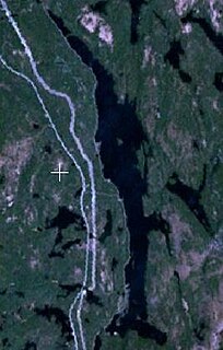
Sturgeon Lake is a lake located 2.0 km (1.2 mi) south of Tomiko and 8.0 km (5.0 mi) north-east of Highway 11 / Trans-Canada Highway in the Nipissing District of northeastern Ontario, Canada. It is in geographic Stewart Township and is part of the Great Lakes Basin.
Rib Lake is a long and narrow lake in the Town of Latchford and in the Municipality of Temagami in Northeastern Ontario, Canada, located about 9 kilometres (6 mi) southeast of the centre of the community of Latchford and 9 kilometres (6 mi) northeast of the community of Temagami North. The lake is in the Ottawa River drainage basin and is the main access for canoeists en route to Rib Mountain.

The Black River is a river in Cochrane District and Timiskaming District in Northeastern Ontario, Canada. It is part of the James Bay drainage basin, and is a right tributary of the Abitibi River. The municipality of Black River-Matheson is named after the river.

The Shebandowan River is a river in Thunder Bay District in Northwestern Ontario, Canada. It is in the Great Lakes Basin and is a left tributary of the Matawin River. Three-quarters of the length of the river valley is paralleled by Ontario Highway 11, at this point part of the Trans-Canada Highway; and the entire length of the river valley is paralleled by a Canadian National Railway main line, built originally as the Canadian Northern Railway transcontinental main line.
The Oskondaga River is a river in Thunder Bay District in Northwestern Ontario, Canada. It is in the Great Lakes Basin and is a left tributary of the Shebandowan River. The river valley is paralleled by Ontario Highway 17, at this point part of the Trans-Canada Highway; and by both the Canadian Pacific Railway transcontinental main line, still in operation, and the Canadian National Railway Graham Subdivision main line, originally built as part of the National Transcontinental Railway, now abandoned.
The Poplar River is a river in the Unorganized North part of Nipissing District in northeastern Ontario, Canada. It is in the Great Lakes Basin.
The Dunrankin River is a river in Algoma District and Sudbury District in northeastern Ontario, Canada. It is in the James Bay drainage basin, begins at Upper Dunrankin Lake and is a left tributary of the Kapuskasing River.
The Swanson River is a river in Sudbury District in northeastern Ontario, Canada. It is in the James Bay drainage basin, begins south of Mageau Lake and is a left tributary of the Chapleau River.
The Nemegosenda River is a river in Algoma District and Sudbury District in northeastern Ontario, Canada. It is in the James Bay drainage basin, and is a right tributary of the Kapuskasing River.
The Shawmere River is a river in Sudbury District in northeastern Ontario, Canada. It is in the James Bay drainage basin, and is a left tributary of the Ivanhoe River.
The Valentine River is a river in the Unorganized North Part of Cochrane District in northeastern Ontario, Canada. It is in the Moose River drainage basin, and is a tributary of Lac Pivabiska, the source of the Pivabiska River.
The Fire River is a river in Algoma District in northeastern Ontario, Canada. It is in the James Bay drainage basin, and is a left tributary of the Missinaibi River.
Tomiko is a dispersed rural community and unincorporated place in geographic Stewart Township, Nipissing District in Northeastern Ontario, Canada. It was created during the construction of the Ontario Northland Railway in the early 20th century. Tomiko is located between the dispersed rural communities of Jocko to the north and Mulock to the south, and has two passing sidings.
Mulock Township is a geographic township in the Unorganized North Part of Nipissing District in Northeastern Ontario, Canada, named for William Mulock. The Ontario Northland Railway, constructed in the early 20th century, runs through the southwestern tip of the township; the dispersed rural community of Mulock with a passing siding is located on the railway.
Ferguson Lake is a lake in the geographic Stewart Township, Nipissing District in Northeastern Ontario, Canada. It is part of the Saint Lawrence River drainage basin.
The Jocko River is a river in Nipissing District in Northeastern Ontario, Canada. It is in the Saint Lawrence River drainage basin, is a right tributary of the Ottawa River, and lies entirely within Jocko Rivers Provincial Park.
Jocko is a dispersed rural community and unincorporated place in geographic Osborne Township in the Unorganized North Part of Nipissing District in Northeastern Ontario, Canada. It was created during the construction of the Ontario Northland Railway in the early 20th century. Jocko is located on the railway line between the railway point of Osborne to the north and the dispersed rural community of Tomiko to the south.
Osborne Township is a geographic township in the Unorganized North Part of Nipissing District in Northeastern Ontario, Canada. The Ontario Northland Railway, constructed in the early 20th century, runs from the middle south to the northwest of the township. The dispersed rural community of Jocko, without any passing sidings, and the railway point of Osborne, with one passing siding, are at the middle south and northwest of the township respectively.
La Salle Township is a geographic township in the Unorganized North Part of Nipissing District in Northeastern Ontario, Canada. The Ontario Northland Railway, constructed in the early 20th century, runs through the southwestern tip of the township; the railway point of Diver is located on the railway.
McLaren's Bay is a Dispersed rural community and unincorporated place in geographic Parkman Township in the Unorganized North Part of Nipissing District in Central Ontario, Canada. The community lies on the eponymous McLaren's Bay on the west shore of Lake Timiskaming, at the mouth of Opimika Creek. McLaren's Point is just north of the community.
