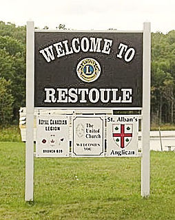
Restoule is a community and designated place in geographic Patterson Township in the Centre Unorganized Part of Parry Sound District in Central Ontario, Canada. It is situated on the Restoule River between Commanda Lake, and Restoule Lake and is part of the Almaguin Highlands region.

The Barron River is a river in the Saint Lawrence River drainage basin in Nipissing District and Renfrew County, Ontario, Canada. It flows from Clemow Lake in northern Algonquin Provincial Park and joins the Petawawa River, whose southern branch it forms, in the municipality of Laurentian Hills, near the municipality of Petawawa.
Speckled Trout Creek is a creek in geographic Labonte Township, Algoma District in Northeastern Ontario, Canada. It is almost entirely in Lake Superior Provincial Park, is in the Great Lakes Basin, and empties into Lake Superior.

James is an incorporated township in the Canadian province of Ontario, located in Timiskaming District. The primary community within the township is Elk Lake, which is located at the junction of Ontario Highway 65 and Ontario Highway 560.

The Groundhog River is a river in Cochrane District and Sudbury District in Northeastern Ontario, Canada. The river is in the James Bay drainage basin and is a left tributary of the Mattagami River.
The Carp River is a river in the Unorganized North Part of Algoma District in Northeastern Ontario, Canada. The river is in the Great Lakes Basin and is a tributary of Lake Superior.
Kapuskasing Lake is a lake in Algoma District and Sudbury District in northeastern Ontario, Canada. It is in the James Bay drainage basin and is the source of the Kapuskasing River. The majority of the lake is in geographic Kapuskasing Township, Algoma District, with just the southern tip in geographic Sherlock Township, Sudbury District.
The Dunrankin River is a river in Algoma District and Sudbury District in northeastern Ontario, Canada. It is in the James Bay drainage basin, begins at Upper Dunrankin Lake and is a left tributary of the Kapuskasing River.
The Nemegosenda River is a river in Algoma District and Sudbury District in northeastern Ontario, Canada. It is in the James Bay drainage basin, and is a right tributary of the Kapuskasing River.
The Shawmere River is a river in Sudbury District in northeastern Ontario, Canada. It is in the James Bay drainage basin, and is a left tributary of the Ivanhoe River.
The Valentine River is a river in the Unorganized North Part of Cochrane District in northeastern Ontario, Canada. It is in the Moose River drainage basin, and is a tributary of Lac Pivabiska, the source of the Pivabiska River.
The Fire River is a river in Algoma District in northeastern Ontario, Canada. It is in the James Bay drainage basin, and is a left tributary of the Missinaibi River.
The Makobe River is a river in northeastern Ontario, Canada. It is in the Saint Lawrence River drainage basin and is a left tributary of the Montreal River.
Tomiko is a dispersed rural community and unincorporated place in geographic Stewart Township, Nipissing District in Northeastern Ontario, Canada. It was created during the construction of the Ontario Northland Railway in the early 20th century. Tomiko is located between the dispersed rural communities of Jocko to the north and Mulock to the south, and has two passing sidings.
Mulock is a dispersed rural community and unincorporated place in geographic Mulock Township, Nipissing District in Northeastern Ontario, Canada, named for William Mulock. It was created during the construction of the Ontario Northland Railway in the early 20th century. Mulock is located between the dispersed rural communities of Tomiko to the north and the Feronia to the south, and has a passing siding.
Mulock is a dispersed rural community and unincorporated place in the municipality of West Grey, Grey County in Southwestern Ontario, Canada, named for William Mulock.
Stewart Township is a geographic township in the Unorganized North Part of Nipissing District in Northeastern Ontario, Canada. The Ontario Northland Railway, constructed in the early 20th century, runs from south to north through the township, and the dispersed rural community of Tomiko with two passing sidings is on the railway in the centre-east.
The Jocko River is a river in Nipissing District in Northeastern Ontario, Canada. It is in the Saint Lawrence River drainage basin, is a right tributary of the Ottawa River, and lies entirely within Jocko Rivers Provincial Park.
Osborne Township is a geographic township in the Unorganized North Part of Nipissing District in Northeastern Ontario, Canada. The Ontario Northland Railway, constructed in the early 20th century, runs from the middle south to the northwest of the township. The dispersed rural community of Jocko, without any passing sidings, and the railway point of Osborne, with one passing siding, are at the middle south and northwest of the township respectively.
Black Duck Creek is a stream in geographic Osborne Township in the Unorganized North Part of Nipissing District in Northeastern Ontario, Canada. It is in the Saint Lawrence River drainage basin, is a left tributary of the Jocko River, and lies entirely within Jocko Rivers Provincial Park.
