Tongaporutu

Last updated

Tongaporutu
NZ-Taranaki plain map.png
Disc Plain red.svg
Tongaporutu
Coordinates: 38°49′12″S174°35′53″E / 38.82000°S 174.59806°E / -38.82000; 174.59806
CountryNew Zealand
Region Taranaki
District New Plymouth District

Tongaporutu is a settlement in northern Taranaki, in the North Island of New Zealand. It is located on State Highway 3 at the mouth of the Tongaporutu River, 15 kilometres south of Mokau.Tongaporutu is well known in New Zealand for its 'Three Sisters' rock formations and its Maori petroglyphs carved into cave rock walls. However,both the Maori rock carvings and the 'Three Sisters formations are constantly being eroded by the Tasman sea.

Taranaki Region of New Zealand in North Island

Taranaki is a region in the west of New Zealand's North Island. It is named after its main geographical feature, the stratovolcano of Mount Taranaki.

North Island The northern of the two main islands of New Zealand

The North Island, also officially named Te Ika-a-Māui, is one of the two main islands of New Zealand, separated from the larger but much less populous South Island by Cook Strait. The island's area is 113,729 square kilometres (43,911 sq mi), making it the world's 14th-largest island. It has a population of 3,749,200.

New Zealand State Highway 3 road in New Zealand

State Highway 3 (SH 3) is one of New Zealand's eight national state highways. It serves the west coast of the country's North Island and forms a link between State Highway 1 and State Highway 2. Distances are measured from north to south.

Contents

Further reading

General historical works

  • History of the Te Horo Tunnel and the Main Road North from New Plymouth to Mokau, New Plymouth, [N.Z.]: Te Horo Restoration Society, 1999
  • Tongaporutu, Ahititi, Okau: centennial booklet 1897-1997, New Plymouth, [N.Z.]: n.p., 1997
  • Gray, Brian E. (2000), The Tongaporutu River Valley: a history of the combined districts of Tongaporutu, Ahititi, Okau, Kotare, Rerekapa, Inglewood, [N.Z.]: Tongaporutu Historical Committee

Business history

  • de Jardine, Margaret (1992), The little ports of Taranaki: being Awakino, Mokau, Tongaporutu, Urenui, Waitara, Opunake, Patea, together with some historical background to each, New Plymouth, [N.Z.]: M. de Jardine, ISBN   0-473-01455-6
International Standard Book Number Unique numeric book identifier

The International Standard Book Number (ISBN) is a numeric commercial book identifier which is intended to be unique. Publishers purchase ISBNs from an affiliate of the International ISBN Agency.

  • "Puke Ariki". Archived from the original on 20 June 2008. in New Plymouth contains the letter book of the Waitara-based shipping agent, Lewis Clare (died 1960). This book records coastal shipping from and into small North Taranaki ports (including those mentioned in de Jardine'sbook) between 1910 and 1920. See "Clare, Lewis (ARC2002-255)" . Retrieved 12 December 2011.
New Plymouth City in Taranaki, New Zealand

New Plymouth is the major city of the Taranaki Region on the west coast of the North Island of New Zealand. It is named after the English city of Plymouth from where the first English settlers migrated. The New Plymouth District, which includes New Plymouth City and several smaller towns, is the 10th largest district in New Zealand, and has a population of 74,184 – about two-thirds of the total population of the Taranaki Region and 1.7% of New Zealand's population. This includes New Plymouth City (58,300), Waitara (6,483), Inglewood (3,380), Oakura (1,359), Okato (561) and Urenui (429).

Waitara, New Zealand Place in Taranaki, New Zealand

Waitara is a town in the northern part of the Taranaki region of the North Island of New Zealand. Waitara is located just off State Highway 3, 15 kilometres (9.3 mi) northeast of New Plymouth. Its population was 6312 in the 2013 census, an increase of 24 from 2006.

Churches

Anglican

  • Parochial District of Saint Peter-by-the-Sea, Mokau: "come unto me"., Mokau, [N.Z.]: Parochial District of Saint Peter-by-the-Sea, 1956

Geology

  • Grange, L.I.; et al. (1927), The geology of the Tongaporutu-Ohura Subdivision, Taranaki Division [Bulletin (New Zealand Geological Survey Branch); new ser. no. 31], Wellington, [N.Z.]: Geological Survey Branch, New Zealand Department of Scientific and Industrial Research
  • Harris, G.E.; et al. (1926), Geological map of Aria survey district, Wellington, [N.Z.]: The SurveyScale: 1: 63 360 (i.e. 1 in. to the mile)
  • Harris, G.E.; et al. (1926), Geological map of Mimi survey district, Wellington, [N.Z.]: The SurveyScale: 1: 63 360 (i.e. 1 in. to the mile)
  • Harris, G.E.; et al. (1926), Geological map of Ohura survey district, Wellington, [N.Z.]: The SurveyScale: 1: 63 360 (i.e. 1 in. to the mile)
  • Harris, G.E.; et al. (1926), Geological map of Pouatu survey district, Wellington, [N.Z.]: The SurveyScale: 1: 63 360 (i.e. 1 in. to the mile)
  • Harris, G.E.; et al. (1926), Geological map of Waro survey district, Wellington, [N.Z.]: The SurveyScale: 1: 63 360 (i.e. 1 in. to the mile)
  • Mills, Carey R. (1988), Gravity expression of the Patea-Tongaporutu High, eastern Taranaki, North Island, New Zealand (M.Sc., Victoria University of Wellington)

Maori

  • Phillips, F.L. (1989–1995), Landmarks of Tainui = Nga tohu a Tainui: a geographical record of Tainui traditional history, Otorohanga, [N.Z.]: Tohu Publishers, ISBN   0-908596-26-X
  • Phillips, F.L. (1995), Landmarks of Tainui = Nga tohu a Tainui: a geographical record of Tainui traditional history, volume two, Otorohanga, [N.Z.]: Tohu Publishers, ISBN   0-908596-32-4

Maps

  • Haylock, A.L. (1895), Tongaporutu improved farms settlement: Mimi survey district, Wellington, [N.Z.]: New Zealand Department of Lands & SurveyScale: 1: 39 600 (i.e. 1/1.6 in. to the mile)
  • Skeet, H.M. (1896), Village of Tongaporutu, Mimi Survey District, Wellington, [N.Z.]: New Zealand Department of Lands & SurveyScale: 1: 3 168 (i.e. 1/20 in. to the mile)
  • New Zealand Department of Lands & Survey (1986), Tongaporutu, Wellington, [N.Z.]: New Zealand Department of Lands & SurveyScale: 1: 50 000 (i.e. 1/1.27 in. to the mile) NZMS 260 ; v Q18

People

  • Genealogical information, a family Bible, and sketches of the Mohakatino and Tongaporutu Rivers are contained within the Messenger family collection held within "Puke Ariki". in New Plymouth. William Messenger, his wife, Mary, and their adult children initially settled at Omata upon arriving in New Zealand in 1853. See "Messenger family". ARC2002-357.
Omata Place in Taranaki, New Zealand

Omata is a locality in Taranaki, in the western North Island of New Zealand. It is located on State Highway 45 just southwest of New Plymouth.

Coordinates: 38°48′S174°36′E / 38.800°S 174.600°E / -38.800; 174.600

Geographic coordinate system Coordinate system

A geographic coordinate system is a coordinate system that enables every location on Earth to be specified by a set of numbers, letters or symbols. The coordinates are often chosen such that one of the numbers represents a vertical position and two or three of the numbers represent a horizontal position; alternatively, a geographic position may be expressed in a combined three-dimensional Cartesian vector. A common choice of coordinates is latitude, longitude and elevation. To specify a location on a plane requires a map projection.


Related Research Articles

Inglewood, New Zealand Place in Taranaki, New Zealand

Inglewood is a town in the Taranaki Region of New Zealand's North Island. It is 16 kilometres (9.9 mi) southeast of New Plymouth on State Highway 3, close to Mount Taranaki/Egmont, and sits 200 metres (660 ft) above sea level. The town services a mainly dairy farming region. The population was 3,246 in the 2013 census, an increase of 156 from 2006.

Hawera Place in Taranaki, New Zealand

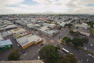
Hawera is the second-largest centre in the Taranaki region of New Zealand's North Island, with a population of 12,150. It is near the coast of the South Taranaki Bight. The origins of the town lie in a government military base that was established in 1866, and the town of Hawera grew up around a blockhouse in the early 1870s.

Mokau River river in New Zealand

The Mokau River is located in the North Island of New Zealand.

Okato Place in Taranaki, New Zealand

Okato is a small town in rural Taranaki, New Zealand. The population was 561 in the 2013 census, an increase of 30 from 2006. It is situated about 25 minutes drive around the coast from New Plymouth on State Highway 45. Oakura is 12 km to the north-east, and Warea is 9 km to the south-west. The place offers popular rocky surfing spots around coastal beaches. The town was established as a military settlement in the 1860s.

Mokau human settlement in New Zealand

Mokau is a small town on the west coast of New Zealand's North Island, located at the mouth of the Mokau River on the North Taranaki Bight. Mokau is in the Waitomo District and Waikato Region local government areas, just north of the boundary with the New Plymouth District and the Taranaki Region. Prior to 1989, the town was classed as being in Taranaki, and there is still a feeling that the community of interest is most associated with New Plymouth, 90 km to the southwest. State Highway 3 passes through the town on its route from Te Kuiti to Waitara and, eventually, New Plymouth.

Te Āti Awa Māori iwi (tribe) in Aotearoa New Zealand

Te Āti Awa is a Māori iwi with traditional bases in the Taranaki and Wellington regions of New Zealand. Approximately 17,000 people registered their affiliation to Te Āti Awa in 2001, with around 10,000 in Taranaki, 2,000 in Wellington and around 5,000 of unspecified regional location.

Lepperton Place in Taranaki, New Zealand

Lepperton is a small village in North Taranaki, New Zealand. It is approximately 6 km (3.7 mi) inland from Waitara township, 5 km (3.1 mi) west of the Waitara River, and 1 km (0.62 mi) east of State Highway 3A, which connects Inglewood to Waitara.

Mount Damper Falls waterfall

Mount Damper Falls is a waterfall in the North Island of New Zealand on a tributary, Mount Damper Stream, of the Tongapōrutu River.

Midhirst Place in Taranaki, New Zealand

Midhirst is a small village in Taranaki, New Zealand, approximately 4 km north of Stratford, on State Highway 3. Inglewood is 17 km (11 mi) north of Midhirst, and New Plymouth is 35 km (22 mi) to the northwest.

Oakura Place in Taranaki, New Zealand

Oakura is a small township in New Plymouth District, Taranaki, in the western North Island of New Zealand. It is located on State Highway 45, 15 kilometres south-west of New Plymouth. Okato is 12 km further south-west. The Oakura River flows past the town and into the North Taranaki Bight. To the south is the Kaitake Range, part of Egmont National Park.

Waipuku is a settlement in inland Taranaki, in the western North Island of New Zealand. It is located between Stratford and Inglewood on State Highway 3.

Urenui Place in Taranaki, New Zealand

Urenui is a settlement in northern Taranaki, in the North Island of New Zealand. It is located on State Highway 3 close to the shore of the North Taranaki Bight, 13 kilometres east of Waitara and 6 km south-west of Mimi. The Urenui River flows past the settlement into the North Taranaki Bight.

Onaero Place in Taranaki, New Zealand

Onaero is a settlement in northern Taranaki, in the North Island of New Zealand. It is located on State Highway 3 close to the shore of the North Taranaki Bight, 15 kilometres (9.3 mi) east of Waitara.

Awakino human settlement in New Zealand

Awakino is a settlement in the south of Waitomo District, in the North Island of New Zealand. It is located on State Highway 3 at the mouth of the Awakino River, five kilometres north of Mokau. It is 79 km southwest of Te Kuiti, and 98 km northeast of New Plymouth.

Taranaki was a New Zealand parliamentary electorate that existed for three periods between 1881 and 1996. It was represented by nine Members of Parliament.

Ngāti Mutunga Māori iwi (tribe) in Aotearoa New Zealand

Ngāti Mutunga is a Māori iwi (tribe) of New Zealand, whose original rohe were in north Taranaki. They migrated from Taranaki, first to Wellington, and then to the Chatham Islands in the 1830s. The rohe of the iwi includes Wharekauri, Te Whanga Lagoon and Waitangi on Chatham Island, and Pitt Island, also part of the Chatham Islands. The principal marae are at Urenui in Taranaki, and the Chatham Islands.

Ahititi Place in Taranaki, New Zealand

Ahititi is a locality in Taranaki, New Zealand. State Highway 3 runs through it. Mokau is 23 km to the north, Mimi is 26 km to the south-west, and Kotare is 16 km to the east. The Tongaporutu River flows through the area and into the North Taranaki Bight at Tongaporutu to the north-west. The name means "fire for cooking" (ahi) "muttonbirds" (titi).

Uruti Place in Taranaki, New Zealand

Uruti is a locality in northern Taranaki, in the North Island of New Zealand. It is located on State Highway 3, north-east of Mimi and south-west of Ahititi. The Uruti Stream meets the Mimi River at this point. The river flows past the settlement into the North Taranaki Bight.