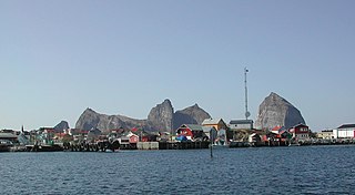
Træna is a municipality in Nordland county, Norway. It is part of the Helgeland traditional region. The administrative centre of the municipality is the island/village of Husøya. Other population centres include Selvær and Sanna.

Helgeland is the most southerly district in Northern Norway. Generally speaking, Helgeland refers to the part of Nordland county that is located south of the Arctic Circle. It is bordered in the north by the Saltfjellet mountains and Svartisen glacier, which form a natural border with the Salten district. In the south, Helgeland borders Trøndelag county.
Harry Danielsen was a Norwegian educator and politician for the Conservative Party, later independent.

Aldra is an island in the municipality of Lurøy in Nordland county, Norway. It is located just off the mainland coast, north of the village of Haugland and west of Brattland. The island is separated from the mainland by the Aldersundet. The islands of Stigen and Lurøya lie to the west. The village of Aldra lies on the southeastern side of the island.

Stokkvågen is a village and ferry port located in Lurøy Municipality in Nordland county, Norway. The village lies on the mainland coast of Lurøy, about 60 kilometres (37 mi) west of the town of Mo i Rana. The port has ferries that connect the mainland to the islands of Onøya, Lovund, Sleneset/Moflag, and Træna to the west and to the town of Sandnessjøen to the south. The village of Stokkvågen is located along Norwegian County Road 17, along the Sjona fjord.
Tonne is a metric unit of mass.
Ulvøya may refer to several islands in Norway:
Sjona is a fjord in Nordland county, Norway. The 26-kilometre (16 mi) fjord begins in the municipality of Rana and flows to the west through Nesna and Lurøy municipalities into the sea. The islands of Handnesøya and Tomma lie at the mouth of the fjord. The deepest part of the fjord reaches 636 metres (2,087 ft) below sea level. Norwegian County Road 17 follows the entire coast of the fjord. Villages along the shore of the fjord include Flostrand, Mæla, and Myklebustad.

Lovund Church is a chapel of the Church of Norway in Lurøy Municipality in Nordland county, Norway. It is located in the island village of Lovund. It is an annex chapel in the Lurøy parish which is part of the Nord-Helgeland prosti (deanery) in the Diocese of Sør-Hålogaland. The white, wooden chapel was built in a long church style in 1960. The building was consecrated on 11 September 1960 by the Bishop Hans Edvard Wisløff.
Lurøy Church is a parish church of the Church of Norway in Lurøy Municipality in Nordland county, Norway. It is located on the south side of the village of Lurøy on the island of Lurøya. It is the main church for the Lurøy parish which is part of the Nord-Helgeland prosti (deanery) in the Diocese of Sør-Hålogaland. The white, wooden church was built in a cruciform style in 1812. The church seats about 375 people.
Moflag Church is a chapel of the Church of Norway in Lurøy Municipality in Nordland county, Norway. It is located in the island village of Moflaget. It is an annex chapel in the Lurøy parish which is part of the Nord-Helgeland prosti (deanery) in the Diocese of Sør-Hålogaland. The white, wooden chapel was built in a long church style in 1921 by the architect Harald J. Hansen. The chapel seats about 150 people.

Aldersund Church is a parish church of the Church of Norway in Lurøy Municipality in Nordland county, Norway. It is located in the village of Haugland. It is the church for the Aldersund parish which is part of the Nord-Helgeland prosti (deanery) in the Diocese of Sør-Hålogaland. The white, wooden church was built in a long church style in 1971 by the architect John Egil Tverdahl. The church seats about 230 people.
Haugland is a village in the municipality of Lurøy in Nordland county, Norway. The village is located on the mainland coast, along the Aldersundet strait between the mainland and the island of Aldra. Norwegian County Road 17 passes through the village. Aldersund Church is located in Haugland, and it serves the eastern part of the municipality.
The Solvær islands are a group of islands in the municipality of Lurøy in Nordland county, Norway. They are located between the islands of Lovund to the west and Onøya to the east. The islands are located about a 90-minute ferry ride west of the mainland. Due to the Gulf Stream, the climate is mild, with little snow despite its northern location.

Lurøya is an island in the municipality of Lurøy in Nordland county, Norway. The 14.2-square-kilometre (5.5 sq mi) island is located just west of the island of Stigen and just north of the island of Onøya. Lurøya has a bridge connection to Onøya. The village of Lurøy is located on Lurøya, and that is the administrative centre of the municipality. Lurøy Church is located on the southwest side of the island. The highest point on the island is the 685-metre (2,247 ft) tall mountain Lurøyfjellet. In 2017, there were 138 residents of the island.

Storselsøya is an island in Nordland county, Norway. The island is divided between two municipalities: Rødøy in the north and Lurøy in the south. The island of Nesøya lies to the west, the island of Lurøya lies to the south, and the mainland village of Tonnes lies to the east.

Nesøya is an island in Nordland county, Norway. The 14.5-square-kilometre (5.6 sq mi) island is located on the border of the municipalities of Rødøy and Lurøylies to the west of the island Storselsøya. The 254-metre (833 ft) tall Nordfjellet mountain is the highest point on the island. The Arctic Circle passes just south of the island. In 2016, there were 126 residents living on the island, which is only accessible by boat.
Tranøy or Tranøya may refer to:

Rana District Court is a district court located in the town of Mo i Rana in Nordland county, Norway. The court serves the central part of the county which includes the municipalities of Rana, Hemnes, Nesna, Lurøy, Træna, and Rødøy. The court is subordinate to the Hålogaland Court of Appeal. The court is led by the chief judge Rolf Selfors, who also leads the neighboring Alstahaug District Court and Brønnøy District Court. This court employs a chief judge, two other judges, and two prosecutors.


