
Tonopah is an unincorporated town in, and the county seat of, Nye County, Nevada, United States. It is located at the junction of U.S. Routes 6 and 95, approximately midway between Las Vegas and Reno. In the 2010 census, the population was 2,478. The census-designated place (CDP) of Tonopah has a total area of 16.2 square miles (42 km2), all land.

The Comstock Lode is a lode of silver ore located under the eastern slope of Mount Davidson, a peak in the Virginia Range in Virginia City, Nevada, which was the first major discovery of silver ore in the United States and named after American miner Henry Comstock.

Rhyolite is a ghost town in Nye County, in the U.S. state of Nevada. It is in the Bullfrog Hills, about 120 miles (190 km) northwest of Las Vegas, near the eastern boundary of Death Valley National Park. The town began in early 1905 as one of several mining camps that sprang up after a prospecting discovery in the surrounding hills. During an ensuing gold rush, thousands of gold-seekers, developers, miners and service providers flocked to the Bullfrog Mining District. Many settled in Rhyolite, which lay in a sheltered desert basin near the region's biggest producer, the Montgomery Shoshone Mine.

The Virginia and Truckee Railroad is a privately owned heritage railroad, headquartered in Virginia City, Nevada. Its private and publicly owned route is 14 miles (23 km) long. When first constructed in the 19th century, it was a commercial freight railroad which was originally built to serve the Comstock Lode mining communities of northwestern Nevada.

The Nevada Northern Railway was a railroad in the U.S. state of Nevada, built primarily to reach a major copper producing area in White Pine County, Nevada. The railway, constructed in 1905–06, extended northward about 140 miles (230 km) from Ely to connections with the Western Pacific Railroad at Shafter and Southern Pacific Railroad at Cobre. In 1967 NN reported 40 million net ton-miles of revenue freight on 162 miles (261 km) of line.

Hamilton is an abandoned mining town located in the White Pine Range, in western White Pine County, Nevada, United States.

Gold Point, Nevada is a well-preserved historic mining town in Esmeralda County, Nevada. The community was named after the local gold-mining industry. Gold Point is the southern terminus of Nevada State Route 774. Its current population is about seven.

Silver Peak is an unincorporated community and census-designated place (CDP) in Esmeralda County, Nevada, United States. It lies along State Route 265, 20 miles (32 km) south of U.S. Route 6 and 30 miles (48 km) west of Goldfield, the county seat of Esmeralda County. It has a post office, with the ZIP code of 89047. The population of Silver Peak was 142 as of 2019.
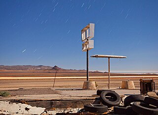
Coaldale is a former mining town and true ghost town in Esmeralda County, Nevada, located at the junction of U.S. Route 6 and U.S. Route 95 about 40 miles (64 km) west of Tonopah.
Silver mining in Nevada, a state of the United States, began in 1858 with the discovery of the Comstock Lode, the first major silver-mining district in the United States. Nevada calls itself the "Silver State." Nevada is the nation's second-largest producer of silver, after Alaska. In 2014 Nevada produced 10.93 million troy ounces of silver, of which 6.74 million ounces were as a byproduct of the mining of gold. The largest byproducers were the Hycroft Mine, the Phoenix Mine, the Midas Mine and Round Mountain.
The History of Nevada as a state began when it became the 36th state on October 31, 1864, after telegraphing the Constitution of Nevada to the Congress days before the November 8 presidential election. Statehood was rushed to help ensure three electoral votes for Abraham Lincoln's reelection and add to the Republican congressional majorities.

The Keane Wonder Mine and mill is an abandoned mining facility located within Death Valley National Park in Inyo County, California. It is located in the Funeral Mountains east of Death Valley and Furnace Creek, California

Eureka Historic District is a historic district in Eureka, Nevada, United States, that is listed on the National Register of Historic Places.
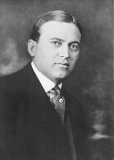
George Wingfield was a Nevada cattleman and gambler who became a financier, investor and one of the state's most powerful economic and political figures during the period from 1909 to 1932. With future senator George S. Nixon as his mentor after he settled in Winnemucca in 1899, and fellow gambler John Hennessy as his partner in the mining boomtown of Tonopah after 1901, Wingfield rose from faro-dealer to become richest man in Nevada in less than five years.
The Tonopah Mining Company Cottage is a historic house located on Queen Street in Tonopah, Nevada. Built in 1902, the home is one of the oldest frame houses in Tonopah. The house was constructed by the Tonopah Mining Company, the largest silver mining company in Tonopah. The cottage was the second home built for the company's employees and the oldest of the three surviving company houses built by the company.
The Tonopah Mining Company House is a historic house located on Queen Street in Tonopah, Nevada. The house was built in 1904 by the Tonopah Mining Company and served as a company house for its employees. The wood-frame house was designed in the Georgian Revival style. The house's design features an entrance porch topped by a gable, three chimneys, boxed eaves, and molded cornices.
The Stone Jail Building and Row House are two adjacent stone buildings located on Water Street in Tonopah, Nevada. The jail was built in 1903 and the adjacent row house in 1908. Both building were at one time used as a brothel. The buildings were added to the National Register of Historic Places in 1982.
Atwood is a former mining settlement located 35 miles (56 km) northeast of Mina in Nye County, Nevada. Founded in 1901, it was the most important mining village in the Fairplay Mining District, that was called "Atwood Mining District" as well. After Atwood was totally deserted in 1908, the settlement revived in 1914. The last resident left the mining settlement in 1959. Currently, only one foundation and fragments of glass remain.
Central Nevada Museum is a non-profit local history museum in Tonopah, Nevada. The museum focuses on the preservation of historical records and artifacts of several counties in Nevada, namely Nye and Esmeralda, as well as several mining towns such as Belmont, Gilbert, and Weepah. It was founded in 1981 by the Central Nevada Historical Society with the help of a grant from the Fleischmann Foundation.

Kodlunarn Island, known as Qallunaaq in Inuktitut and originally named Countess of Warwick Island, is a small island located in Frobisher Bay in the Canadian territory of Nunavut. During the 1570s, explorer Martin Frobisher led expeditions to the island to mine what he believed was gold ore. The ore turned out to be worthless, and the island was ignored by explorers until Charles Francis Hall, inspired by oral history accounts from the Inuit of Frobisher Bay, visited the site in 1861 to investigate the remains of Frobisher's expeditions. Notable features of the island include two large mining trenches and the remains of a stone house built by Frobisher in 1578. Kodlunarn Island was designated a National Historic Site of Canada in 1964.


