Glass House Mountains National Park is a heritage-listed national park at Glass House Mountains, Sunshine Coast Region, Queensland, Australia. It is also known as Beerburrum Forest Reserve 1. It is 70 km (43 mi) north of Brisbane and consists of a flat plain punctuated by rhyolite and trachyte volcanic plugs, the cores of extinct volcanoes that formed 27 million to 26 million years ago. The mountains would once have had pyroclastic exteriors, but these have eroded away.

Brisbane is the capital of and the most populated city in the Australian state of Queensland, and the third most populous city in Australia. Brisbane's metropolitan area has a population of over 2.5 million, and the South East Queensland metropolitan region, centred on Brisbane, encompasses a population of more than 3.6 million. The Brisbane central business district stands on the historic European settlement and is situated inside a peninsula of the Brisbane River, about 15 kilometres from its mouth at Moreton Bay, a bay of the Coral Sea. The metropolitan area extends in all directions along the hilly floodplain of the Brisbane River Valley between Moreton Bay and the Taylor and D'Aguilar mountain ranges. It sprawls across several of Australia's most populous local government areas (LGAs)—most centrally the City of Brisbane, which is by far the most populous LGA in the nation. The demonym of Brisbane is "Brisbanite", whilst common nicknames include "Brissy", "River City" and "Brisvegas".

Tarragindi is a southern suburb of the City of Brisbane, Queensland, Australia. It is represented through the Holland Park and Moorooka Ward councillors on the Brisbane City Council. In the 2016 census, Tarragindi had a population of 10,779 people.
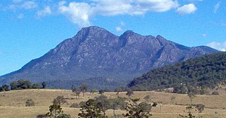
Mount Barney is a mountain within the Scenic Rim Region in south-east Queensland, Australia. It lies approximately 130 kilometres (81 mi) south-west of Brisbane, not far from the Queensland - New South Wales border, and forms part of the McPherson Range. It is a popular destination for bushwalkers and campers. Mount Barney is the sixth or seventh highest mountain in Queensland and is often regarded as one of the most impressive parts of the Scenic Rim. The mountain consists of two main peaks,, and smaller subsidiary peaks. East Peak is probably the most popular destination for bushwalkers.

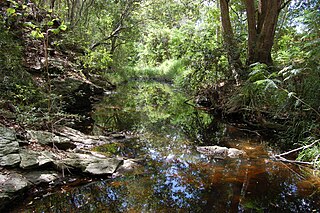
Bulimba Creek, originally known as Doboy Creek or Doughboy Creek, ia a perennial stream that is a tributary of the Brisbane River, located in suburban Brisbane in the South East region of Queensland, Australia.

Sunnybank Hills is an outer southern suburb in the City of Brisbane, Queensland, Australia. In the 2016 census, Sunnybank Hills had a population of 18,085 people.

Mount Gravatt is a southern suburb of the City of Brisbane, Queensland, Australia and a prominent hill within this suburb. In the 2016 census, Mount Gravatt had a population of 3,366 people.

Mount Coot-tha is a mountain and a suburb of the City of Brisbane, Queensland, Australia. In the 2016 census, there were no residents in the suburb.
The D'Aguilar Range is a mountain range near Brisbane, Queensland, Australia. The town of Dayboro is situated on the lower foothills midway along the range and the Sunshine Coast Hinterland town of Mooloolah lies at the northernmost point of the range. Many residential areas line its eastern slopes including the town of Samford and the suburb of Ferny Hills. In the west, numerous ridges and gullies are heavily forested and designated as state forest or national park.

The Taylor Range or Herbert Taylor Range is a mountain range on the western edge of Brisbane, Queensland, Australia. It was first named The Glenmorrison Range by John Oxley during his exploration of the area in January 1824. In 1828, the colonial botanist Charles Fraser, whilst looking at the range from the Ipswich area, noted the bearings as Sir Herbert Taylor’s Range from which the current name derived.

The Illawarra escarpment, or officially the Illawarra Range, is the fold-created cliffs and plateau-eroded outcrop mountain range west of the Illawarra coastal plain south of Sydney, in the state of New South Wales, Australia. The range encloses the Illawarra region which stretches from Stanwell Park in the north to Kiama, Gerringong and the Shoalhaven River in the south.

Nathan is a suburb in the City of Brisbane, Queensland, Australia. In the 2016 census, Nathan had a population of 1183 people.
Salisbury is a southern suburb in the City of Brisbane, Queensland, Australia. In the 2016 census, Salisbury had a population of 6,290 people.

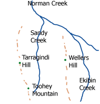
Norman Creek is a small tributary of the Brisbane River. The headwaters of the creek are located on the northern slopes of Toohey Mountain and Mount Gravatt in southern Brisbane. The name derives from a corruption of Gorman's Creek, after Lieutenant Gorman, of H. M. 8th Foot - the last commandant at Moreton Bay.

The City of Brisbane is a local government area (LGA) which comprises the inner portion of the metropolitan area of Brisbane, the capital of Queensland, Australia. Its governing body is the Brisbane City Council. Unlike LGAs in the other mainland state capitals, which are generally responsible only for the central business districts and inner neighbourhoods of those cities, the City of Brisbane administers a significant portion of the Brisbane metropolitan area, serving almost half of the population of the Brisbane Greater Capital City Statistical Area (GCCSA). As such, it has a larger population than any other local government area in Australia. The City of Brisbane was the first Australian LGA to reach a population of more than one million. Its population is roughly equivalent to the populations of Tasmania, the Australian Capital Territory and the Northern Territory combined. In 2016–2017, the council administered a budget of over $3 billion, by far the largest budget of any LGA in Australia.
Ithaca Creek is a waterway in the Enoggera Creek catchment, in the western suburbs of Brisbane, Queensland, Australia. It arises in the Taylor Range at the Mount Coot-tha forest with two streams, one arising at J C Slaughter Falls, the other and stronger source being Simpson Falls, the western branch.
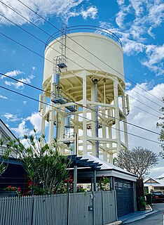
Paddington Water Tower is a heritage-listed water tower at 16 Garfield Drive, Paddington, City of Brisbane, Queensland, Australia. It was designed by Metropolitan Water Supply & Sewerage Board and built by day labour in 1927. It was added to the Queensland Heritage Register on 23 June 2000.

The Geography of Brisbane is characterised by its coastal location in the south eastern corner of the Queensland state of Australia. It is located precisely halfway up the Australian east coast with longitudinal and latitudinal coordinates of 27.5° south and 153° east. The city resides within the Moreton Bay Floodplain, stretching from Caboolture to the north, Beenleigh to the south and as far as Ipswich to the west whilst being bordered by the Pacific Ocean to the east.
James Toohey (1827-1883) was a prominent Irish-Australian land owner of the early colony of Brisbane.