Related Research Articles

Landing is the last part of a flight, where a flying animal, aircraft, or spacecraft returns to the ground. When the flying object returns to water, the process is called alighting, although it is commonly called "landing", "touchdown"a or "splashdown" as well. A normal aircraft flight would include several parts of flight including taxi, takeoff, climb, cruise, descent and landing.
Free flight is a developing air traffic control method that uses no centralized control. Instead, parts of airspace are reserved dynamically and automatically in a distributed way using computer communication to ensure the required separation between aircraft. This new system may be implemented into the U.S. air traffic control system in the next decade. Its potential impact on the operations of the national airspace system is disputed, however.

In aerodynamics, the lift-to-drag ratio is the lift generated by an aerodynamic body such as an aerofoil or aircraft, divided by the aerodynamic drag caused by moving through air. It describes the aerodynamic efficiency under given flight conditions. The L/D ratio for any given body will vary according to these flight conditions.
The basic principles of air navigation are identical to general navigation, which includes the process of planning, recording, and controlling the movement of a craft from one place to another.

In aviation, airspeed is the speed of an aircraft relative to the air it is flying through. It is difficult to measure the exact airspeed of the aircraft, but other measures of airspeed, such as indicated airspeed and Mach number give useful information about the capabilities and limitations of airplane performance. The common measures of airspeed are:

In aviation, an electronic flight instrument system (EFIS) is a flight instrument display system in an aircraft cockpit that displays flight data electronically rather than electromechanically. An EFIS normally consists of a primary flight display (PFD), multi-function display (MFD), and an engine indicating and crew alerting system (EICAS) display. Early EFIS models used cathode ray tube (CRT) displays, but liquid crystal displays (LCD) are now more common. The complex electromechanical attitude director indicator (ADI) and horizontal situation indicator (HSI) were the first candidates for replacement by EFIS. Now, however, few flight deck instruments cannot be replaced by an electronic display.

In aviation, an instrument approach or instrument approach procedure (IAP) is a series of predetermined maneuvers for the orderly transfer of an aircraft operating under instrument flight rules from the beginning of the initial approach to a landing, or to a point from which a landing may be made visually. These approaches are approved in the European Union by EASA and the respective country authorities and in the United States by the FAA or the United States Department of Defense for the military. The ICAO defines an instrument approach as "a series of predetermined maneuvers by reference to flight instruments with specific protection from obstacles from the initial approach fix, or where applicable, from the beginning of a defined arrival route to a point from which a landing can be completed and thereafter, if landing is not completed, to a position at which holding or en route obstacle clearance criteria apply."

Terrain-following radar (TFR) is a military aerospace technology that allows a very-low-flying aircraft to automatically maintain a relatively constant altitude above ground level and therefore make detection by enemy radar more difficult. It is sometimes referred to as ground hugging or terrain hugging flight. The term nap-of-the-earth flight may also apply but is more commonly used in relation to low-flying military helicopters, which typically do not use terrain-following radar.
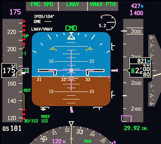
A primary flight display or PFD is a modern aircraft instrument dedicated to flight information. Much like multi-function displays, primary flight displays are built around a Liquid-crystal display or CRT display device. Representations of older six pack or "steam gauge" instruments are combined on one compact display, simplifying pilot workflow and streamlining cockpit layouts.

A flight management system (FMS) is a fundamental component of a modern airliner's avionics. An FMS is a specialized computer system that automates a wide variety of in-flight tasks, reducing the workload on the flight crew to the point that modern civilian aircraft no longer carry flight engineers or navigators. A primary function is in-flight management of the flight plan. Using various sensors (such as GPS and INS often backed up by radio navigation) to determine the aircraft's position, the FMS can guide the aircraft along the flight plan. From the cockpit, the FMS is normally controlled through a Control Display Unit (CDU) which incorporates a small screen and keyboard or touchscreen. The FMS sends the flight plan for display to the Electronic Flight Instrument System (EFIS), Navigation Display (ND), or Multifunction Display (MFD). The FMS can be summarised as being a dual system consisting of the Flight Management Computer (FMC), CDU and a cross talk bus.
In aviation, vertical navigation is glidepath information provided during an instrument approach, independently of ground-based navigation aids in the context of an approach and a form of vertical guidance in the context of climb/descent. An onboard navigation system displays a constant rate descent path to minimums. The VNAV path is computed using aircraft performance, approach constraints, weather data, and aircraft weight. The approach path is computed from the top of descent point to the end of descent waypoint, which is typically the runway or missed approach point.
Required navigation performance (RNP) is a type of performance-based navigation (PBN) that allows an aircraft to fly a specific path between two 3D-defined points in space.

An autothrottle is a system that allows a pilot to control the power setting of an aircraft's engines by specifying a desired flight characteristic, rather than manually controlling the fuel flow. The autothrottle can greatly reduce the pilots' work load and help conserve fuel and extend engine life by metering the precise amount of fuel required to attain a specific target indicated air speed, or the assigned power for different phases of flight. A/T and AFDS can work together to fulfill the whole flight plan.

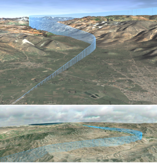
Area navigation is a method of instrument flight rules (IFR) navigation that allows an aircraft to choose any course within a network of navigation beacons, rather than navigate directly to and from the beacons. This can conserve flight distance, reduce congestion, and allow flights into airports without beacons. Area navigation used to be called "random navigation", hence the acronym RNAV.

Scandinavian Airlines System Flight 933 was a scheduled international flight from Denmark to the United States that on January 13, 1969, crashed into Santa Monica Bay at 19:21, approximately 6 nautical miles (11 km) west of Los Angeles International Airport (LAX) in California, United States. The crash into the sea was caused by pilot error during approach to runway 07R; the pilots were so occupied with the nose gear light not turning green that they lost awareness of the situation and failed to keep track of their altitude. The Scandinavian Airlines System (SAS) aircraft had a crew of nine and 36 passengers, of whom 15 died in the accident. The flight originated at Copenhagen Airport, Denmark, and had a stopover at Seattle–Tacoma International Airport, where there was a change of crew. The crash was similar to Eastern Air Lines Flight 401. The crash site was in international waters, but the National Transportation Safety Board carried out an investigation, which was published on July 1, 1970. The report stated the probable cause as improper crew resource management and stated that the aircraft was fully capable of carrying out the approach and landing. The aircraft was conducting an instrument approach, but was following an unauthorized back course approach.
A step climb in aviation is a series of altitude gains that improve fuel economy by moving into thinner air as an aircraft becomes lighter and becomes capable of flying in the thinner air at a higher altitude.

A gravity turn or zero-lift turn is a maneuver used in launching a spacecraft into, or descending from, an orbit around a celestial body such as a planet or a moon. It is a trajectory optimization that uses gravity to steer the vehicle onto its desired trajectory. It offers two main advantages over a trajectory controlled solely through the vehicle's own thrust. First, the thrust is not used to change the spacecraft's direction, so more of it is used to accelerate the vehicle into orbit. Second, and more importantly, during the initial ascent phase the vehicle can maintain low or even zero angle of attack. This minimizes transverse aerodynamic stress on the launch vehicle, allowing for a lighter launch vehicle.
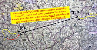
In aviation, the top of climb, also referred to as the TOC or T/C, is the computed transition from the climb phase of a flight to the cruise phase, the point at which the planned climb to cruise altitude is completed. The top of climb is usually calculated by an on-board flight management system and is designed to provide the most economical climb to cruise altitude or to meet some other objective. The top of climb may be calculated manually with considerable effort.

Aeroflot Flight 2808 was a scheduled domestic passenger flight from Mineralnye Vody to Ivanovo, both in Russia, with a stopover in Donetsk, Ukraine on 27 August 1992. While attempting to land at Ivanovo airport, the Tupolev Tu-134 crashed into a group of buildings in the village of Lebyazhy Lug. Investigators determined the cause of the accident was errors made by the crew and the air traffic controller. There were no fatalities on the ground, but all 84 people on board the flight died in the crash.

Kuban Airlines Flight 5719 was a flight during which an aviation accident occurred involving an Antonov An-26b aircraft of the Russian airline Kuban Airlines, on Sunday, December 26, 1993 during landing at Shirak International Airport in Gyumri (Armenia), causing the deaths of 35 people. It was the largest aviation disaster in Armenia since 1991.
References
- ↑ "VFR Top of Descent Calculation" (PDF). ivao.aero. Retrieved 27 June 2018.