
In aviation, instrument flight rules (IFR) is one of two sets of regulations governing all aspects of civil aviation aircraft operations; the other is visual flight rules (VFR).

The basic principles of air navigation are identical to general navigation, which includes the process of planning, recording, and controlling the movement of a craft from one place to another.

Cruise is the phase of aircraft flight that starts when the aircraft levels off after a climb, until it begins to descend for landing. Cruising usually consumes the majority of a flight, and it may include changes in heading, airspeed and altitude.

A flight engineer (FE), also sometimes called an air engineer, is the member of an aircraft's flight crew who monitors and operates its complex aircraft systems. In the early era of aviation, the position was sometimes referred to as the "air mechanic". Flight engineers can still be found on some larger fixed-wing airplanes and helicopters. A similar crew position exists on some spacecraft. In most modern aircraft, their complex systems are both monitored and adjusted by electronic microprocessors and computers, resulting in the elimination of the flight engineer's position.

In aviation, airspeed is the speed of an aircraft relative to the air. Among the common conventions for qualifying airspeed are:
A motor glider is a fixed-wing aircraft that can be flown with or without engine power. The FAI Gliding Commission Sporting Code definition is: a fixed-wing aerodyne equipped with a means of propulsion (MoP), capable of sustained soaring flight without thrust from the means of propulsion.
Calibrated airspeed (CAS) is indicated airspeed corrected for instrument and position error.

Flight plans are documents filed by a pilot or flight dispatcher with the local Air Navigation Service Provider prior to departure which indicate the plane's planned route or flight path. Flight plan format is specified in ICAO Doc 4444. They generally include basic information such as departure and arrival points, estimated time en route, alternate airports in case of bad weather, type of flight, the pilot's information, number of people on board, and information about the aircraft itself. In most countries, flight plans are required for flights under IFR, but may be optional for flying VFR unless crossing international borders. Flight plans are highly recommended, especially when flying over inhospitable areas such as water, as they provide a way of alerting rescuers if the flight is overdue. In the United States and Canada, when an aircraft is crossing the Air Defense Identification Zone (ADIZ), either an IFR or a special type of VFR flight plan called a DVFR flight plan must be filed. For IFR flights, flight plans are used by air traffic control to initiate tracking and routing services. For VFR flights, their only purpose is to provide needed information should search and rescue operations be required, or for use by air traffic control when flying in a "Special Flight Rules Area."

Trim tabs are small surfaces connected to the trailing edge of a larger control surface on a boat or aircraft, used to control the trim of the controls, i.e. to counteract hydro- or aerodynamic forces and stabilise the boat or aircraft in a particular desired attitude without the need for the operator to constantly apply a control force. This is done by adjusting the angle of the tab relative to the larger surface.

Flight planning is the process of producing a flight plan to describe a proposed aircraft flight. It involves two safety-critical aspects: fuel calculation, to ensure that the aircraft can safely reach the destination, and compliance with air traffic control requirements, to minimise the risk of midair collision. In addition, flight planners normally wish to minimise flight cost through the appropriate choice of route, height, and speed, and by loading the minimum necessary fuel on board. Air Traffic Services (ATS) use the completed flight plan for separation of aircraft in air traffic management services, including tracking and finding lost aircraft, during search and rescue (SAR) missions.
A flight management system (FMS) is a fundamental component of a modern airliner's avionics. An FMS is a specialized computer system that automates a wide variety of in-flight tasks, reducing the workload on the flight crew to the point that modern civilian aircraft no longer carry flight engineers or navigators. A primary function is in-flight management of the flight plan. Using various sensors to determine the aircraft's position, the FMS can guide the aircraft along the flight plan. From the cockpit, the FMS is normally controlled through a Control Display Unit (CDU) which incorporates a small screen and keyboard or touchscreen. The FMS sends the flight plan for display to the Electronic Flight Instrument System (EFIS), Navigation Display (ND), or Multifunction Display (MFD). The FMS can be summarised as being a dual system consisting of the Flight Management Computer (FMC), CDU and a cross talk bus.
Direct User Access Terminal Service (DUATS) was a weather information and flight plan processing service contracted by the Federal Aviation Administration (FAA) for use by United States civil pilots and other authorized users. The DUAT Service was a telephone- and Internet-based system which allowed the pilot to use a personal computer for access to a Federal Aviation Administration (FAA) database to obtain weather and aeronautical information and to file, amend, and cancel domestic IFR and VFR flight plans. DUATS provided direct access to weather information via a National Airspace System (NAS) Data Interchange Network II (NADIN-II) interface to the Weather Message Switching Center Replacement (WMSCR) System and the Air traffic control (ATC) Facilities for filing flight plans. The pilot users could interface DUAT Services via the FTS-2001 toll free telephone numbers or via an Internet Interface into the Contractor's Facility. The service could be accessed by direct dial, and the Internet via Telnet or HTTP.

The SOCATA TBM is a family of high-performance single-engine turboprop business and utility light aircraft manufactured by Daher. It was originally collaboratively developed between the American Mooney Airplane Company and French light aircraft manufacturer SOCATA.
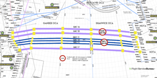
North Atlantic Tracks, officially titled the North Atlantic Organised Track System (NAT-OTS), is a structured set of transatlantic flight routes that stretch from the northeast of North America to western Europe across the Atlantic Ocean, within the North Atlantic airspace region. They ensure that aircraft are separated over the ocean, where there is little radar coverage. These heavily travelled routes are used by aircraft flying between North America and Europe, operating between the altitudes of 29,000 and 41,000 ft inclusive. Entrance and movement along these tracks is controlled by special oceanic control centres to maintain separation between aircraft. The primary purpose of these routes is to allow air traffic control to effectively separate the aircraft. Because of the volume of NAT traffic, allowing aircraft to choose their own co-ordinates would make the ATC task far more complex. They are aligned in such a way as to minimize any head winds and maximize tail winds impact on the aircraft. This results in much more efficiency by reducing fuel burn and flight time. To make such efficiencies possible, the routes are created twice daily to take account of the shifting of the winds aloft and the principal traffic flow, eastward in North America evening and westward twelve hours later.

Armavia Flight 967 was a scheduled international passenger flight operated by Armavia from Zvartnots International Airport, Zvarnots in Armenia to Sochi, a Black Sea coastal resort city in Russia. On 3 May 2006, the aircraft operating the route, an Airbus A320-200, crashed into the sea while attempting to go-around following its first approach to Sochi airport, killing all 113 aboard.

On October 25, 1999, a chartered Learjet 35 business jet was scheduled to fly from Orlando, Florida, United States to Dallas, Texas, United States. Early in the flight, the aircraft, which was climbing to its assigned altitude on autopilot, lost cabin pressure, and all six on board were incapacitated by hypoxia, a lack of oxygen in the brain and body. The aircraft continued climbing past its assigned altitude, then failed to make the westward turn toward Dallas over North Florida and continued on its northwestern course, flying over the southern and midwestern United States for almost four hours and 1,500 miles (2,400 km). The plane ran out of fuel over South Dakota and crashed into a field near Aberdeen after an uncontrolled descent.
A step climb in aviation is a series of altitude gains that improve fuel economy by moving into thinner air as an aircraft becomes lighter and becomes capable of flying in the thinner air at a higher altitude.

The Champion 402 Lancer is a twin-engine trainer produced by Champion Aircraft, a high-wing monoplane based on the tricycle gear Champion 7FC Tri-Traveler, but with wing-mounted Continental O-200-A engines. The Lancer first flew in 1961 and production began in 1963. The Lancer seats two in a tandem configuration with dual flight controls; the pilot in command or student pilot normally occupies the front seat.
A zoom climb is a climb where the rate of climb is greater than the maximum climb rate using only the thrust of the aircraft's engines. The additional climb rate is attained by reduction of horizontal speed. Before a zoom climb, the aircraft accelerates to a high air speed at an altitude at which it can operate in sustained level flight. The pilot then pulls steeply upward, trading the kinetic energy of forward motion for altitude. The aircraft gains potential energy (altitude) at the expense of kinetic energy. This is different from a steady climb, where the increase in potential energy comes from mechanical work done by the engines, rather than from the aircraft's kinetic energy.
Flight Express, Inc. was a cargo airline owned by Bayside Capital. Bayside Capital acquired Flight Express on November 4, 2008. Flight Express, Inc. operates as an air courier company in the Southeast and Midwest United States. It offers air freight and ground courier services. The company also operates aircraft. It specializes in the transport of cargo for banking and financial institutions, life sciences organizations, newspaper publishers, overnight freight delivery companies, and payroll and photographic processors. It operates 84 aircraft from facilities in eight states. It was founded in 1985 and is based in Orlando, Florida, USA.
