
Phitsanulok, is a province of central Thailand. It borders the provinces of Uttaradit to the north, Loei and Phetchabun to the east, Phichit to the south, Kamphaeng Phet to the southwest, and Sukhothai to the west. Its border was shared with Laos (Sainyabuli) to the northeast. Covering an area of 10,815 square kilometres (4,176 sq mi), Phitsanulok is the fifteenth-largest province in Thailand. As of 2023, it has a population of about 840,000, making it the eighth-most populous province in the region.

The Phetchabun mountains are a mountain massif in Phetchabun, Phitsanulok, Loei and Chaiyaphum Provinces, Thailand. It consists of two parallel mountain chains, with the valley of the Pa Sak River in the middle.

Northern Thailand, or more specifically Lanna, is geographically characterised by several mountain ranges, which continue from the Shan Hills in bordering Myanmar to Laos, and the river valleys that cut through them. Like most of Thailand, it has a tropical savanna climate, but its relatively high elevation and latitude contribute to more pronounced seasonal temperature variation, with cooler winters than the other regions.

The Nan River is a river in Thailand. It is one of the most important tributaries of the Chao Phraya River.

Mueang Nakhon Sawan is the capital district of Nakhon Sawan province, in central Thailand.

Chat Trakan is the northernmost district (amphoe) of Phitsanulok province, central Thailand.

Wat Bot is a district (amphoe) in the northern part of Phitsanulok province, central Thailand.
Wang Thong is a district (amphoe) of Phitsanulok province, central Thailand.

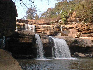
Namtok Kaeng Sopha is a waterfall in Wang Thong District, Phitsanulok Province, Thailand. It is in Thung Salaeng Luang National Park on the Wang Thong River off of Lomsak Road. It is the largest waterfall in Phitsanulok. Kaeng Sopha is a tiered waterfall shaped like a stairway. Kaeng Sopha is the subject of a June 2007 postage stamp in Thailand in the Thailand Waterfall series.

The Wang Thong River is a river in Thailand. Its source lies in the Phetchabun Mountains in the Khao Kho District, Thailand. It flows through Thung Salaeng Luang National Park and forms Namtok Sri Dit and Namtok Kaeng Sopha in the Wang Thong District of Phitsanulok Province, and finally flows through into the Bang Krathum District, passing through Ban Sam Ruen and on to the border of Phitsanulok and Phichit, where it drains into the Nan River at 16°31′06″N100°19′36″E. The land drained by the Wang Thong River is part of the Nan Basin and the Chao Phraya Watershed.
The Khwae Noi River in northern Thailand is a tributary of the Nan River. It shares the same name as another river in Thailand, the popular tourist attraction also known as "The River Kwai." These are two distinct bodies of water.
Thung Salaeng Luang National Park is a 1,262 square kilometres (487 sq mi) national park in Phitsanulok and Phetchabun Provinces of Thailand. It encompasses substantial portions of Wang Thong and Lom Sak Districts.

Namtok Chat Trakan National Park is a national park located in Chat Trakan and Nakhon Thai Districts of Phitsanulok Province of Thailand, established in 1987. It encompasses Lam Kwae Noi, Daeng and Chat Trakan forests a substantial portion of Chat Trakan District.
Khwae Noi National Park is a national park in Chat Trakan, Nakhon Thai, Wang Thong and Wat Bot districts in Phitsanulok Province, Thailand, it was formerly known as Kaeng Chet Kwae National Park.
Ban Klang is a subdistrict in Wang Thong district, Phitsanulok province. The subdistrict has a wide forest, mountainous with a flat area interspersed with hills. In 2022 it had a population of 20,174. The economy is mainly based on agriculture.
Wang Nok Aen is a sub-district in the Wang Thong District of Phitsanulok Province. It is connected to Highway 12. In 2022 it had a population of 16,310.

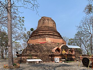
The lands situated in the present-day Phitsanulok Province of Thailand have been inhabited since the Stone Age, although the neolithic inhabitants of the region are not likely to have been the ancestors of the modern Thai people who reside there today. The earliest historical records relating to what is now Phitsanulok Province indicates that at a time prior to or during the 11th century, the present-day city of Phitsanulok was but a small strategic Khmer outpost known as Song Khwae. During the next century, in 1188, Nakhon Thai, located near the center of the present Phitsanulok Province, was established as the capital city of the Singhanavati Kingdom, an early city-state of Thailand. Later, during Thailand's Sukhothai Period, the city of Phitsanulok emerged as a major city in the east of the Sukhothai Kingdom, and the great temples of Wat Chula Manee, Wat Aranyik and Wat Chedi Yod Thong were constructed. In 1357, the renowned Wat Phra Sri Rattana Mahathat was erected, and the Ayutthaya Period witnessed the construction of several of the province's other chief temples. Phitsanulok served for 25 years as the capital city of the Ayutthaya Kingdom. In 1555, King Naresuan the Great was born in the city of Phitsanulok. Naresuan played a significant role in the history of Thailand, as he expanded the kingdom to its greatest territorial extent, by conquering sizable portions of modern-day Burma and Cambodia. In recent times, Phitsanulok Province has become an important agricultural center, part of the Bread Basket of Thailand, providing rice and other crops to consumers in Thailand and throughout the world. Extensive agricultural development over the last hundred years or so has spawned a modern infrastructure in the urban areas of the province, bringing with it an array of modern roads, universities, hospitals and other conveniences. Over the years, the Nan River and its tributaries have played a substantial role in the history and development of the region by providing a route for transportation, fertile soil for agriculture, and water for irrigation. The river waters have also served as a route for enemy invaders, and have been the source of periodic widespread flooding throughout the province.

The Khao Kho National park is located in Lom Kao, Lom Sak, Khao Kho and Mueang Phetchabun districts in Thailand's Phetchabun province. The national park covers an area of 483 square kilometres (186 sq mi) and was established in 2012.

Phitsanulok is a city in Northern Thailand, the capital of Phitsanulok province and the tenth-largest city in Thailand. It is 360 km north of Bangkok and has a population of 281,929 people as of 2021. The city was founded in the 13th century under the name Song Khwae and represents one of the oldest cities in Thailand.

