Ragusa is a city and comune in southern Italy. It is the capital of the province of Ragusa, on the island of Sicily, with 73,288 inhabitants in 2016. It is built on a wide limestone hill between two deep valleys, Cava San Leonardo and Cava Santa Domenica. Together with seven other cities in the Val di Noto, it is part of a UNESCO World Heritage Site.
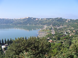
Castel Gandolfo, colloquially just Castello in the Castelli Romani dialects, is a town located 25 kilometres (16 mi) southeast of Rome in the Lazio region of Italy. Occupying a height on the Alban Hills overlooking Lake Albano, Castel Gandolfo has a population of approximately 8,900 residents and is considered one of Italy's most scenic towns.

Cascia is a town and comune (municipality) of the Italian province of Perugia in a rather remote area of the mountainous southeastern corner of Umbria. It is about 21 km from Norcia on the road to Rieti in the Lazio (63 km). It is also very close to Terni.

Paternò is a southern Italian town and comune of the Metropolitan City of Catania, Sicily. With a population (2016) of 48,009, it is the third municipality of the province after Catania and Acireale.

Castell'Arquato is an Italian town located on the first hills of Val D’Arda in the province of Piacenza, in Emilia-Romagna, approximately 30 kilometres (19 mi) from Piacenza and 35 kilometres (22 mi) from Parma. Places nearby include Bacedasco, Vigolo Marchese, Fiorenzuola d'Arda, Lugagnano Val d'Arda, and Vernasca.

Teggiano is a town and comune in Campania, Italy, in the province of Salerno. It is situated on an isolated eminence above the upper part of the valley to which it gives the name of Vallo di Diano.
Castel San Giorgio is a town and comune in the province of Salerno in the Campania region of south-western Italy. In 2011, it had a population of 13,411.

Torremaggiore is a town, comune (municipality) and former seat of a bishopric, in the province of Foggia in the Apulia, region of southeast Italy.

Sant'Anatolia di Narco is a comune (municipality) in the Province of Perugia in the Italian region Umbria, located about 60 km southeast of Perugia, in the middle Valnerina valley. It is a medieval town commanded by a 12th-century castle, with a 14th-century line of walls.

Carona is a former municipality in the district of Lugano in the canton of Ticino in Switzerland. On 14 April 2013 the former municipalities of Bogno, Cadro, Carona, Certara, Cimadera, Valcolla and Sonvico merged into the municipality of Lugano.
San Mariano is a village of the municipality of Corciano in the Province of Perugia, Umbria, central Italy. It stands at an elevation of 315 metres above sea level and was named for San Mariano. The village lies over three hills: the first with a castle, the second with a cemetery and the third near the place called "La Badia." From the top of the hills can be seen San Sisto and Lacugnana Hill eastwards, the plane of Castel del Piano to the south, Solomeo towards the west and the villages of Ellera and Olmo northwards. Notable monuments are the old castle, the medieval church and the monument dedicated to the soldiers of the 1st world war. Just next to the parish church is the Rachel Marro public gardens fitted with benches in the middle of some thriving olive trees. In a corner of the gardens there is a memorial stone with the carved names of those who gave their lives during the two world wars. At the time of the Istat census of 2001 it had 1152 inhabitants. San Mariano is connected by bus routes with the city of Perugia. During recent years it has developed many commercial activities such as malls and cinemas built in the plane near the village.

Montorgiali is a village in Tuscany, central Italy, administratively a frazione of the comune of Scansano, province of Grosseto. At the time of the 2001 census its population amounted to 141.

Montegiovi is a village in Tuscany, central Italy, administratively a frazione of the comune of Castel del Piano, province of Grosseto, in the area of Mount Amiata. At the time of the 2001 census its population amounted to 168.

Montenero d'Orcia is a village in Tuscany, central Italy, administratively a frazione of the comune of Castel del Piano, province of Grosseto, in the area of Mount Amiata. At the time of the 2001 census its population amounted to 253.
Sticciano is a village in Tuscany, central Italy, administratively a frazione of the comune of Roccastrada, province of Grosseto. At the time of the 2001 census its population amounted to 686.

Buriano is a village in Tuscany, central Italy, administratively a frazione of the comune of Castiglione della Pescaia, province of Grosseto. At the time of the 2001 census its population amounted to 257.

Catabbio is a village in Tuscany, central Italy, administratively a frazione of the comune of Semproniano, province of Grosseto. At the time of the 2001 census its population amounted to 203.

Sant'Angelo in Colle is a village in Tuscany, central Italy, administratively a frazione of the comune of Montalcino, province of Siena. At the time of the 2011 census its population amounted to 204.

Poggi del Sasso is a village in Tuscany, central Italy, administratively a frazione of the comune of Cinigiano, province of Grosseto. At the time of the 2001 census its population amounted to 88.

Ravi is a village in Tuscany, central Italy, administratively a frazione of the comune of Gavorrano, province of Grosseto. At the time of the 2001 census its population amounted to 263.