
The Alpine region of Switzerland, conventionally referred to as the Swiss Alps, represents a major natural feature of the country and is, along with the Swiss Plateau and the Swiss portion of the Jura Mountains, one of its three main physiographic regions. The Swiss Alps extend over both the Western Alps and the Eastern Alps, encompassing an area sometimes called Central Alps. While the northern ranges from the Bernese Alps to the Appenzell Alps are entirely in Switzerland, the southern ranges from the Mont Blanc massif to the Bernina massif are shared with other countries such as France, Italy, Austria and Liechtenstein.

Morzine, alternatively known as Morzine-Avoriaz, is an alpine commune on the Swiss border in the Haute-Savoie department in the Auvergne-Rhône-Alpes region in Southeastern France.

Les Portes du Soleil is a major skisports destination in the Alps, encompassing thirteen resorts between Mont Blanc in France and Lake Geneva in Switzerland. With more than 650 km of marked pistes and about 200 lifts in total, spread over 14 valleys and about 1,036 square kilometres (400 sq mi), Portes du Soleil ranks among the two largest ski areas in the world. Almost all of the pistes are connected by lifts – a few marginal towns can be reached only by the free bus services in the area. The highest elevation accessible on skis is 2260 m and the lowest is 930 m. As with many other Alpine ski resorts, the lower slopes of the Portes du Soleil have snow-making facilities to extend the ski season by keeping the lower slopes open during the warmer months.

Anzère is a small village in the canton of Valais, Switzerland, located in the municipality of Ayent and close to Sion and Crans. A south-facing purpose-built resort in traditional Swiss architectural style.

Les Gets is a commune in the Haute-Savoie department in the Auvergne-Rhône-Alpes region in south-eastern France.
Châtel is a commune on the Swiss border in the Haute-Savoie department in the Auvergne-Rhône-Alpes region in Southeastern France. In 2019, it had a population of 1,246. Situated in the northern part of the French Alps, Châtel is part of the French-Swiss ski domain known as Portes du Soleil. Despite its development into a major ski resort, the village still retains many of its traditional alpine characteristics.
Maurienne is one of the provinces of Savoy, corresponding to the arrondissement of Saint-Jean-de-Maurienne in France. It is also the original name of the capital of the province, now Saint-Jean-de-Maurienne.
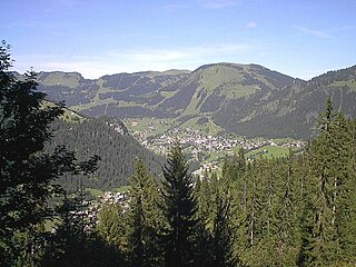
Champéry is a municipality in the district of Monthey in the canton of Valais in Switzerland.
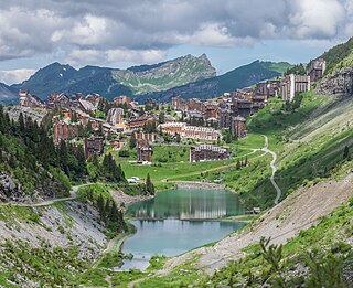
Avoriaz is a French mountain resort in the heart of the Portes du Soleil. It is located in the territory of the commune of Morzine. It is easily accessible from either Thonon at Lake Geneva or Cluses station on the A40 motorway between Geneva and Chamonix. Either way one follows the D902, Route des Grandes Alpes, to Morzine and then the D338 running from Morzine to Avoriaz. Snow chains are often necessary. Avoriaz is built on a shelf high above the town of Morzine, which is among the pioneering towns of skiing with its first lifts dating back to the early 1930s. Today Avoriaz is one of the major French ski destinations catering for all standards of skiing and ranks among the top snowboarding destinations of the world. Apart from snow-based pursuits, Avoriaz is also a centre for trekking, golf, VTT and other outdoor activities during the summer. Cars are forbidden in Avoriaz. The resort is designed to be fully skiable. Other transport around the resort includes horse-drawn sleighs and snowcats during winter.

Saint-Jean-d'Aulps is a commune in the Haute-Savoie department in the Auvergne-Rhône-Alpes region in south-eastern France. Situated in the heart of the Vallée d'Aulps, as well as being the home to an active farming community, it is popular with holiday-makers in the Summer, for walking, and in the Winter for skiing as it is a part of the massive Portes du Soleil ski area.
Le Pas de Chavanette, also known as the "Mur Suisse" or "Swiss Wall", is a particularly steep and difficult piste in the Portes du Soleil ski area, on the border between France and Switzerland. It can be reached from the French resort of Avoriaz and from the Swiss towns of Les Crosets and Champéry. Effectively, one starts the run standing on the Swiss-French border, plunging down the Swiss side of the mountain towards Les Crosets.

Champex is a village located in the French-speaking Swiss canton of Valais, part of the municipality of Orsières.

The Vallée de Joux is a valley of the Jura Mountains mainly in the Swiss Canton of Vaud. The valley also continues into France at its higher, southwestern, end. Located 30 miles (48 km) north of Geneva and northwest of Lausanne, its mean elevation is over 3,300 feet (1,000 m). There are three Swiss lakes in the Vallée de Joux: the lac de Joux, the lac Brenet and Lake Ter. The French border runs along the northern edge of the valley until, about 10 kilometres (6.2 mi) west of the lac de Joux, the base of the valley becomes French territory. The valley then continues to climb gently towards the Lac des Rousses and the ski resort of Les Rousses.

La Chapelle-d'Abondance is a commune in the Haute-Savoie department in the Auvergne-Rhône-Alpes region in south-eastern France.

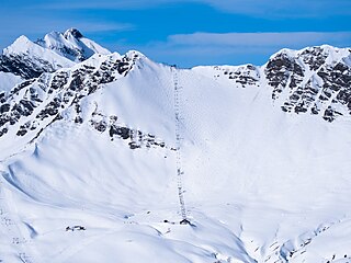
Les Crosets is a village and ski resort in the Canton of Valais, Switzerland. It is part of the Val-d'Illiez municipality, and Portes du Soleil ski area.

Les Diablerets is a village and ski resort located in the municipality of Ormont-Dessus in the canton of Vaud, Switzerland.

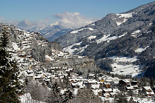
Morgins is a village in the municipality of Troistorrents in the district of Monthey in the canton of Valais in southern Switzerland.

Les Paccots is a village and a small ski resort of the Swiss Prealps, located in the canton of Fribourg.

Champoussin is a village in the Swiss Alps, located in the canton of Valais. The village is situated in the western part of the canton, near Champéry, in the municipality of Val-d'Illiez.

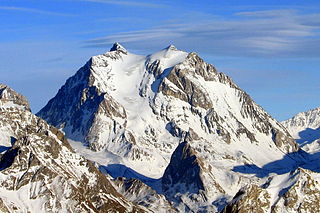
The Pointe des Mossettes is a mountain of the Chablais Alps, overlooking Les Crosets in the Swiss canton of Valais. The French border runs west of the summit on a straight line, although the mountain lies on the main watershed between the Dranse river basin and the Val d'Illiez.
