The Torngat Mountains are a mountain range on the Labrador Peninsula at the northern tip of Newfoundland and Labrador and eastern Quebec. They are part of the Arctic Cordillera. The mountains form a peninsula that separates Ungava Bay from the Atlantic Ocean.

The Baffin coastal tundra is a small ecoregion of the far north of North America, on the central north coast of Baffin Island in the Canadian territory of Nunavut. This is permafrost tundra with an average annual temperature below freezing.

Taymyr Nature Reserve is a Russian 'zapovednik' located in the northern lowlands of Siberia, on the Taimyr Peninsula, and on the coast of the Laptev Sea of the Arctic Ocean. The reserve includes the most northern forest of Dahurian larch in the world, and also the most northern mainland mountain range in the world. The protected area was established to protect the breeding grounds of the Red-breasted goose as well as the summer residences of wild reindeer and the biodiversity of the Lake Taymyr. The reserve is situated about 120 km east of the town of Norilsk, and 3,000 km northeast of Moscow, in the Taymyrsky Dolgano-Nenetsky District of Krasnoyarsk Krai. In 1995, the site was designated a UNESCO MAB Reserve. The reserve was formally established in 1979, and covers an area of 1,781,928 ha (6,880.06 sq mi).

The Northeast Siberian taiga ecoregion is an area of "sparse taiga forest" between the Lena River and the Kolyma River in northeastern Siberia, Russia. The ecoregion's internal borders form a patchwork of territory constituting the southern part of the East Siberian Lowland, as well as lowlands around the East Siberian Mountains, including the ridges and peaks of the Verkhoyansk Range and the Chersky Range. On the southern border of the ecoregion is the north coast of the Sea of Okhotsk, giving the region maritime boreal forests as well as the continental forests situated inland. The ecoregion is one of the largest tracts of virgin boreal forest in the world, due to the very sparse population and difficult access. It is mostly in the Sakha Republic.
Northern Canadian Shield taiga is a taiga ecoregion located in northern Canada, stretching from Great Bear Lake in the Northwest Territories to Hudson Bay in eastern Nunavut. The region supports conifer forests to its northern edge, where the territory grades into tundra. The open forest in this transition zone is characterized by widely scattered, stunted stands of black spruce and tamarack, with some white spruce. The ecoregion lies over the northwestern extent of the Canadian Shield.

The Canadian Arctic tundra is a biogeographic designation for Northern Canada's terrain generally lying north of the tree line or boreal forest, that corresponds with the Scandinavian Alpine tundra to the east and the Siberian Arctic tundra to the west inside the circumpolar tundra belt of the Northern Hemisphere.

The Transbaikal Bald Mountain tundra ecoregion covers the high-altitude peak zones above the treeline in a series of mountain ranges that stretch from the northern reaches of Lake Baikal to the western coastal ranges of the Okhotsk Sea. Floral communities are those of mountain tundra, with bare rock or permafrost under layers of moss and lichen. Because the ecoregion is aligned along a common latitude, it acts as a route for the transmission of species across Siberia. The ecoregion is in the Palearctic realm and the tundra biome. It has an area of 217,559 square kilometres (84,000 sq mi).

The Southern Hudson Bay taiga is a terrestrial ecoregion, as classified by the World Wildlife Fund, which extends along the southern coast of Hudson Bay and resides within the larger taiga biome. The region is nearly coterminous with the Hudson Plain, a Level I ecoregion of North America as designated by the Commission for Environmental Cooperation (CEC) in its North American Environmental Atlas.
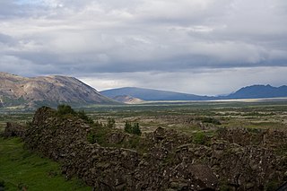
The Iceland boreal birch forests and alpine tundra ecoregion covers the island of Iceland in the North Atlantic. The island is volcanic in origin with basaltic soils, and the cold northerly climate prevents any significant crop agriculture. Because the island is young and isolated from larger land masses, species biodiversity is relatively low. Forest cover has been reduced to about 1% of the original birch forest by a long history of timber extraction and soil erosion caused by sheep grazing. Blanket bogs are common.
The Northwest Territories taiga ecoregion (WWF:NA0614) is located in the Northwest Territories and Yukon provinces of Canada. It covers forest and tundra along the Mackenzie River Valley and the surrounding highlands in the southern portion of the valley.

The Davis Highlands tundra ecoregion covers the Baffin Mountains on the northeast coast of Baffin Island and Bylot Island, facing Baffin Bay in Nunavut, northern Canada. The terrain is extremely rugged, heavily glaciated, with many deep fjords, and very cold. About half of the territory is moss and lichen tundra, the other half bare rock and ice. The region is wetter than the much drier regions to the southwest of the Baffin Islands.

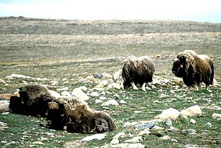
The Canadian High Arctic Tundra ecoregion encompasses most of the northern Arctic archipelago, from much of Baffin Island, Somerset Island, and Prince of Wales Island in the south, through all islands northward to the most northern island in Canada, Ellesmere Island. Much of the northern islands are covered in ice, and the climate is very dry with as little as 50 mm/year in places. The ecoregion has very little human habitation, and most of the non-ice terrain is moss and lichen cover. The region supports viable populations of arctic mammals such as muskox, arctic wolves, arctic foxes, arctic hares, polar bears, and caribou.

The Interior Yukon-Alaska alpine tundra ecoregion covers alpine, sub-alpine, and boreal forest areas along the cordillera of Interior Alaska and south-central Yukon Territory. Geologically, they are the disjunct uplands of the Yukon-Tanana Terrane plus a southern extension of the Brooks Range. The cover is extensive 'dark taiga' of closed spruce forest, open forest of other species, and alpine vegetation at higher altitudes. The region is mostly wilderness and relatively untouched by human development.

The Kalaallit Nunaat high arctic tundra ecoregion covers the coastal areas of northern including the upper half of the west coast and the upper one-third of the east coast. Greenland. Areas inland of this strip of land are either covered in ice or bare rock. About one-third of the region is covered by mosses and lichens, and another 3% by herbaceous vegetation and shrubs. The largest national park in the world, Northeast Greenland National Park, protects a majority of the land within the ecoregion. The Pituffik Space Base is also located in this ecoregion.

The Kalaallit Nunaat Arctic Steppe ecoregion covers the low coastal areas of western and southern Greenland, reaching in up to 100 km before bare rock and ice become dominant. While much of the ecoregion is bare rock or ice, about 50% of the ground is covered in moss and lichen, and another 10% in herbaceous cover, shrubs, and even small stands of trees.

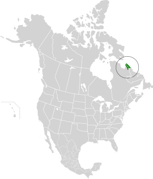
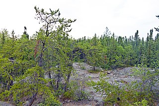
The Canadian Low Arctic Tundra ecoregion covers a rolling landscape of shrubby tundra vegetation along the northern edge of the mainland Canada along the border of the Northwest Territories and Nunavut, and a small portion in Quebec on the northeast coast of Hudson Bay. The region is important for large herds of caribou and other large mammals, and for large nesting colonies of birds such as snow geese. The region is mostly intact, with 95% remaining intact.
The Canadian Middle Arctic Tundra ecoregion covers a broad stretch of northern Canada - the southern islands of the Arctic Archipelago, plus the northern mainland of Nunavut and, across Hudson Bay to the east, a portion of northern Quebec. This is the coldest and driest ecoregion in Canada, and can be referred to as a 'polar desert'. It is an important region for breeding and migratory birds, and supports 80% of the world's muskox.

The Ogilvie–MacKenzie alpine tundra ecoregion covers the mountainous middle of the Yukon Territory in Canada, with extensions into the Northwest Territories. The vegetation is alpine and subalpine open forest of stunted spruce, fir and pine. The area is rugged but sections appear to have been unglaciated in the late Pleistocene and there are therefore relic species in the region. The area is remote and supports large, sustainable predator-prey systems.

Kytalyk National Park is a protected area for the Arctic breeding grounds of migratory birds on the East Asian–Australasian Flyway, including a significant portion of sites for the critically endangered Siberian crane. The name "kytalyk" is the Yakut-language word for the Siberian crane. The park is on the low-lying tundra of the delta of the Indigirka River, on the East Siberian Sea in northern Russia. The park was officially created in 2019. The park is located in Allaikhovsky District of the Sakha Republic.

The Tundra of North America is a Level I ecoregion of North America designated by the Commission for Environmental Cooperation (CEC) in its North American Environmental Atlas.