Related Research Articles

Banning is a city in Riverside County, California, United States. Its population was 29,505 as of the 2020 census, down from 29,603 at the 2010 census. It is situated in the San Gorgonio Pass, also known as Banning Pass. It is named for Phineas Banning, stagecoach line owner and the "Father of the Port of Los Angeles."

The Santa Rosa Mountains are a short mountain range in the Peninsular Ranges system, located east of the Los Angeles Basin and northeast of the San Diego metropolitan area of Southern California, in the Southwestern United States.
The Agua Caliente Band of Cahuilla Indians of the Agua Caliente Indian Reservation is a federally recognized tribe of the Cahuilla, located in Riverside County, California, United States. The Cahuilla inhabited the Coachella Valley desert and surrounding mountains between 5000 BCE and 500 CE. With the establishment of the reservations, the Cahuilla were officially divided into 10 sovereign nations, including the Agua Caliente Band.

Thermal is an unincorporated community within the Coachella Valley in Riverside County, California, United States, located approximately 25 miles (40 km) southeast of Palm Springs and about 9.5 miles (15.3 km) north of the Salton Sea. The community's elevation is 138 feet (42 m) below mean sea level. It is served by area codes 760 and 442 and is in ZIP Code 92274. The population was 2,865 at the 2010 census. For statistical purposes, the United States Census Bureau has defined Thermal a census-designated place (CDP), which does not precisely correspond to the historical community.

The Mojave Road, also known as Old Government Road, is a historic route and present day dirt road across what is now the Mojave National Preserve in the Mojave Desert in the United States. This rough road stretched 147 miles (237 km) from Beale's Crossing, to Fork of the Road location along the north bank of the Mojave River where the old Mojave Road split off from the route of the Old Spanish Trail/Mormon Road.

The Augustine Band of Cahuilla Indians is a federally recognized Cahuilla band of Native Americans based in Coachella, California. They are one of the smallest tribal nations in the United States, consisting of only 16 members, seven of whom are adults.
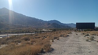
Whitewater is a census-designated place in Riverside County, California. It is directly off Interstate 10 halfway between North Palm Springs and Cabazon on the way from Palm Springs to Los Angeles. It is known as the site of the San Gorgonio Pass Wind Farm. The ZIP Code is 92282, and the community is inside area code 760. The population was 859 at the 2010 census. The elevation is 1,575 feet (480 m).
Today's Bradshaw Trail is a historic overland stage route in the western Colorado Desert of Southern California. It is a remnant of the much longer Bradshaw Road, also known as the Road to La Paz, or Gold Road, established in 1862 by William D. Bradshaw. It was the first overland route to connect the gold fields near La Paz in the U.S. New Mexico Territory, later the Arizona Territory, to Southern California's more populated west coast. Once in La Paz, additional roads provided access to the mining districts of the central New Mexico/Arizona Territory, near Wickenburg and Prescott.

The Ramona Band of Cahuilla is a federally recognized tribe of Cahuilla Indians, located in Riverside County, California.
The Cabazon Band of Cahuilla Indians is a federally recognized tribe of Cahuilla Indians, located in Riverside County, California. They were formerly known as the Cabazon Band of Mission Indians.
The Santa Rosa Band of Cahuilla Indians is a federally recognized tribe of Cahuilla Indians, located in Riverside County, California.
The Torres Martinez Desert Cahuilla Indians is a federally recognized tribe of Cahuilla Indians, located in Imperial and Riverside counties in California. Their autonym is Mau-Wal-Mah Su-Kutt Menyil, which means "among the palms, deer moon." in the Cahuilla language.

The Morongo Band of Mission Indians is a federally recognized tribe in California, United States. The main tribal groups are Cahuilla and Serrano. Tribal members also include Cupeño, Luiseño, and Chemehuevi Indians. Although many tribes in California are known as Mission Indians, some, such as those at Morongo, were never a part of the Spanish Missions in California.
San Felipe Creek is a stream in Imperial and San Diego Counties of California. It arises in the Volcan Mountains of San Diego County 33°11′57″N116°37′35″W, and runs eastward, gathering the waters of most of the eastern slope of the mountains and desert of the county in the San Sebastian Marsh before it empties into the Salton Sea. It is probably the last remaining perennial natural desert stream in the Colorado Desert region. In 1974, the San Felipe Creek Area was designated as a National Natural Landmark by the National Park Service.

Tahquitz Canyon is located in Palm Springs, California on a section of the Agua Caliente Indian Reservation. The canyon descends from the Riverside County San Jacinto Mountains. It was continually inhabited for at least 5,000 years by the Native American Cahuilla people, and is one of many canyons of cultural significance to the Cahuilla. Today it is a nature preserve open to the public that is overseen by the Agua Caliente Band of Cahuilla Indians.
Butterfield Valley is a valley along the course of Temecula Creek, in Riverside County, California. Its lower end is now filled by Vail Lake. It heads at 33°27′39″N116°55′34″W and its mouth is at the site of the Vail Lake Dam at the head of the deep canyon Temecula Creek has cut through Oak Mountain to the Pauba Valley.
Hamilton Creek is a tributary stream of Cahuilla Creek,, in Riverside County, California. Its mouth is found in the Anza Valley at an elevation of 3,865 feet (1,178 m). Its source is at 33°32′46″N116°34′36″W at an elevation of 4,800 feet on the southwest facing slope of Lookout Mountain in the Santa Rosa Mountains.
Cahuilla Creek is a tributary stream of Wilson Creek which is in turn a tributary of Temecula Creek, and the Santa Margarita River in Riverside County, California. Its mouth is at its confluence with Wilson Creek at an elevation of 2,106 feet (642 m). Its source is at 33°36′40″N116°40′10″W, at an elevation of 5,800 feet, on the west slope of Thomas Mountain 0.6 miles west-southwest of Tool Box Spring. It flows southwest through the Anza Valley and Cahuilla Valley in the Cahuilla Indian Reservation to Wilson Creek, 7 miles south-southwest of Cahuilla Mountain and 20 miles south-southeast of San Jacinto.
Martinez is a populated place on the lands of the Torres-Martinez Desert Cahuilla Indians in Riverside County, California. It lies at an elevation of −135 feet.
References
- ↑ U.S. Geological Survey Geographic Names Information System: Torres
- ↑ U.S. Geological Survey Geographic Names Information System: Toro Cemetery
- ↑ Topographical Sketch showing the Outward and Inward Route of a Party, while examining as to the practicability of a Diversion of the Colorado River for Purposes of Irrigation, Lithograph by Eric Bergland, 1875. From, Wheeler, G.M., Topographical Atlas Projected To Illustrate United States Geographical Surveys West Of The 100th Meridian Of Longitude Prosecuted In Accordance With Acts Of Congress Under The Authority Of The Honorable The Secretary Of War, And The Direction Of Brig. Genl. A.A. Humphreys, Chief Of Engineers, U.S. Army. Embracing Results Of the Different Expeditions Under The Command Of 1st Lieut. Geo. M. Wheeler, Corps Of Engineers. Julius Bien, lith., G. Thompson, Washington, 1876. Distances between stations and watering places on the Bradshaw Trail taken from this survey map.