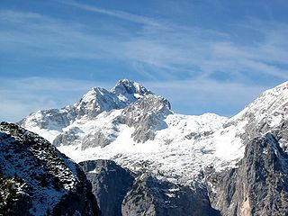
Triglav, with an elevation of 2,863.65 metres (9,395.2 ft), is the highest mountain in Slovenia and the highest peak of the Julian Alps. The mountain is the pre-eminent symbol of the Slovene nation. It is the centrepiece of Triglav National Park, Slovenia's only national park. Triglav was also the highest peak in Yugoslavia before Slovenia's independence in 1991.
The Julian Alps are a mountain range of the Southern Limestone Alps that stretch from northeastern Italy to Slovenia, where they rise to 2,864 m at Mount Triglav, the highest peak in Slovenia and of the former Yugoslavia. A large part of the Julian Alps is included in Triglav National Park. The second highest peak of the range, the 2,755 m high Jôf di Montasio, lies in Italy.

The Triglav Lakes Valley is a rocky hanging valley in the Julian Alps in Slovenia, below the sheer sides of Mount Tičarica and Mount Zelnarica southwest of Triglav. The valley is also called the Seven Lakes Valley, although there are ten and not seven lakes in the valley. It is above the tree line and is geologically alpine karst; therefore it has also been termed the Sea of Stone Valley.

Grintovec is the highest mountain of the Kamnik–Savinja Alps, with an elevation of 2,558 metres (8,392 ft). It is a popular location for hiking, climbing and skiing. The first recorded ascent was in 1759 by the botanist Giovanni Antonio Scopoli.

Eastern Alps is the name given to the eastern half of the Alps, usually defined as the area east of a line from Lake Constance and the Alpine Rhine valley up to the Splügen Pass at the Alpine divide and down the Liro River to Lake Como in the south. The peaks and mountain passes are lower than the Western Alps, while the range itself is broader and less arched.

Mojstrana is a village in the Municipality of Kranjska Gora in the Upper Carniola region of Slovenia.

Krma is an alpine valley in the Julian Alps in the Upper Carniola region, northwestern Slovenia. It is included in the Triglav National Park in its entirety.

The Jôf di Montasio is located in the Province of Udine, in the Friuli-Venezia Giulia region of northeastern Italy.

Toško Čelo is a dispersed settlement on the slope of the hill known as Tošč Face, part of the Polhov Gradec Hills, west of the capital Ljubljana in central Slovenia. The area is part of the traditional region of Upper Carniola and is now included with the rest of the municipality in the Central Slovenia Statistical Region. It belongs to the City Municipality of Ljubljana.

Razor is a pyramidal mountain in the Julian Alps and the sixth-highest mountain in Slovenia. First ascended by Otto Sendtner in 1842, it is now frequently ascended, with numerous mountain huts available for climbers.

Mount Saint Mary, originally known as Holm, is an inselberg in the north of Ljubljana, the capital of Slovenia. The mountain is part of the city's Šmarna Gora District. It is the highest hill in the city and a popular hiking destination.

Storžič is the highest mountain in the western part of the Kamnik–Savinja Alps. The top is a nicely shaped cone, from which the mountain got its name. Storžič has a good panoramic view. To the south are the Ljubljana Basin, Mount Krim, the Javornik Hills, Mount Snežnik, the Nanos Plateau, and the Škofja Loka Hills. To the west are the Julian Alps with prominent Mount Triglav. To the north are the Karawanks with Mount Stol, Mount Begunjščica, and Mount Košuta. To the east are the Jezersko Cirque, Mount Grintovec, the Kalce Ridge and Mount Krvavec.

Tošč is the highest hill in the Polhov Gradec Hills. The neighbouring hill Pasja Ravan used to be the highest before Yugoslav Army reduced its height by eight meters in the 1970s.

The Triglav Lakes Lodge is a mountain lodge between Double Lake and the artificial Lake Močivec below Mount Tičarica in the heart of the Julian Alps, northwestern Slovenia. The first structure was built in 1880 by an Austrian hiking club. In 1955 and 1988, it was rebuilt and expanded. It has four dining rooms with 150 seats, 13 rooms with 30 beds, and 13 larger sleeping rooms with 170 bunks. The lodge is open from the end of June until the start of October

Vogel is a 1922 m high mountain in Slovenia, part of southern Julian Alps and Triglav National Park. There is a cable car from Lake Bohinj to a height of 1537 m.

The Planika Lodge at Triglav is a mountain hut, which lies on the Ledine plains on the southern side of Mount Triglav. The First hut, also called the Triglav Tempe, was built on 18 September 1871. In 1877, the Austro-German hiking club built a hut called the Maria Theresa Hut. On 13 August 1911, there was another building added called the Maria Theresa Lodge. After World War I, the Slovenian Hiking club took over the hut and renamed it the Aleksander Lodge. The hut was transformed to a border garrison Karaula for a while. In 1945, the Gorje Hiking Club renamed it to Planika Lodge at Triglav. In 1987, Karaula was demolished and a bigger annex was built at its place on 19 August 1992.

Aljaž Lodge in the Vrata Valley is a mountain hut that lies near the stream Triglav Bistrica in the upper end of the Vrata Valley. The hut is named after the Slovene priest and composer Jakob Aljaž (1845–1927), who in 1896 ordered the construction of the first wooden hut in the valley. The original Aljaž Lodge was built in 1904, and rebuilt in 1910 after the previous one was destroyed by an avalanche. Aljaž Lodge is the starting point to ascend the mountains Triglav, Škrlatica and Cmir.

The Triglav Lodge at Kredarica is the highest mountain hut in Slovenia and the highest meteorological station in the country. It stands on a small plateau just under the peak of Kredarica, an elevation in the ridge between Rjavina and Triglav. The Valentin Stanič Lodge stands to the northeast below Begunje Peak, and the Planika Lodge at Triglav stands to the south. In the vicinity there is also a chapel dedicated to Our Lady of the Snows, and a few metres away there is a small cave named Ivačič Cave.
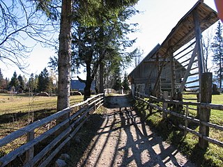
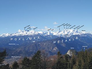
Uskovnica is an Alpine pasture on Pokljuka plain in the Bohinj area, belonging to the village Srednja vas v Bohinju. The majority of the alm cottages are now used as vacation and tourist facilities.
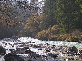
The Triglav Bistrica is a stream that flows through the glacial Vrata Valley southwest of Mojstrana, Slovenia. Its source is below the north face of Mount Triglav in the blind Bukovlje Valley, and it flows past the Aljaž Lodge. In addition to several intermittent tributaries with a flashy character, it also has three constant tributaries, all of them flowing from valleys below the east slope of Mount Škrlatica: Dry Creek, Red Creek, and Peričnik Creek. The Triglav Bistrica empties into the Sava Dolinka at Mojstrana. It falls 400 meters (1,300 ft) during its approximately 10-kilometer (6.2 mi) course.

