45°40′49″N0°50′59″W / 45.68028°N 0.84972°W | |
Location | Saint-Romain-de-Benet, Charente-Maritime |
---|---|
Type | Pile |
Classified as MH (1840) |
The Tour de Pirelonge is a Gallo-Roman stone tower, also referred to as a funerary pile, situated to the east of Saujon in the commune of Saint-Romain-de-Benet (Charente-Maritime, France).
This monument, likely constructed during the Roman Empire along the ancient road connecting Saintes to Bordeaux, is a cenotaph in the form of a solid column, standing 24 meters high with a square base and a conical cap.
The structure has been relatively well-preserved and has been designated as a historical monument since the initial list was published in 1840.
The tower is situated along the Roman road that connected Mediolanum Santonum (Saintes) to Burdigala (Bordeaux), as referenced in the Peutinger Table and the Antonine Itinerary. [1]
In modern topography, the tower is located just over a kilometer south of Saint-Romain-de-Benet. Positioned at an altitude of 37 meters, it sits at the summit of a rise, surrounded by vineyards and woodlands, with no nearby structures. [2]
The toponym "Pirelonge" is believed to derive from the Greek term for "long stone" or "tall stone," a name often applied to funerary piles. [3]
Dating the tower is challenging, but the foundations include reused elements from an earlier monument, such as a 1st-century AD capital. This suggests that the tower was constructed at a later period, likely under the Antonine emperors, similar to the dating for the Pile d'Aumagne. [4]
As documented by Claude Masse in 1715, [5] the initial written references depict a remarkably well-preserved monument, exhibiting a condition nearly identical to that observed in the 20th century. [6]
The Tour de Pirelonge was designated a historical monument in the 1840 list [7] and subsequently underwent restoration in 1989. [8]
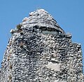
The tower has a height of 24 meters and a width of approximately 6 meters at its base, tapering slightly at two points along its ascent. Each of its faces is oriented towards a cardinal point. Constructed of rubble stone bonded with mortar, it culminates in a well-preserved conical crown, [9] suggesting that the entire structure was similarly faced with large ashlar blocks, although this facing has since disappeared. [6]
Despite the absence of a discernible niche, the excavations conducted by "treasure hunters" on the east and south sides of the monument were sealed during the 1989 restoration. Many surveys have demonstrated the absence of an interior chamber, indicating that, akin to other analogous monuments, the tower is solid. In the late 19th century, [10] excavations identified the remnants of an enclosure [11] on three of its sides, [12] and burials were discovered within this perimeter. [8]
This tower is comparable to the Pile d'Ebéon in the commune of Authon-Ébéon, which is much less well-preserved, [13] or to the Pile d'Aumagne , whose elevation has disappeared. All three are located in the civitas of the Santons and close to the major ancient road from Poitiers to Bordeaux. [14] After the Pile de Cinq-Mars, which stands at 29.40 meters, the Tour de Pirelonge represents the second-tallest preserved monument of this type in Gaul. [15]
The precise function of the structure remained uncertain for some time. In the late 19th century, it was postulated to be either a geographical marker, [16] a landmark, [17] or a mausoleum. [18]
The convergence of knowledge about the Tour de Pirelonge and other similar structures in France now allows for a clearer understanding of its function. It can be inferred with a high degree of certainty that it is a cenotaph dedicated to an individual of considerable importance, as is the case with the majority of other identified piles in France. This is particularly indicated by a funerary enclosure at its base. [19]
Camille Jullian was a French historian, philologist, archaeologist and historian of literature.
Cinq-Mars-la-Pile is a commune in the Indre-et-Loire department in central France.
The Aqueduct of Luynes is a former Gallo-Roman bridge aqueduct located in Luynes, France.
The Tours amphitheater is a Roman amphitheatre located in the historic city center of Tours, France, immediately behind the well known Tours cathedral. It was built in the 1st century when the city was called Caesarodunum. It was built atop a small hill on the outskirts of the ancient urban area, making it safe from floods, convenient for crowds and visitors, and demonstrating the power of the city from a distance. The structure was an enormous, elliptical structure approximately 122 meters by 94 meters. According to its design it is classified as a "primitive" amphitheatre. Unlike the famous Colosseum that was made mostly of masonry and built above-ground, the Tours amphitheatre was made mostly of earth and created by moving soil and rock into a bowl shape. Spectators likely sat directly on the grassy slopes, while the masonry was primarily used for the vomitoria and retaining walls.
Marcel Le Glay was a 20th-century French historian and archaeologist, specializing in ancient Rome. His work focused in particular on Roman religion and North Africa during Antiquity, especially from Latin literature epigraphic: his monumental thesis, dedicated to the cult of Saturn in Africa, is meeting his three favorite areas.
The "Temple of Janus" is a Romano-Celtic religious structure located in Autun, Saône-et-Loire, France, to the North-West of the ancient city of Augustodunum.
The Tower of Vesunna is the vestige of a Gallo-Roman fanum (temple) dedicated to Vesunna, a tutelary goddess of the Petrocorii. The sanctuary was built in the 1st or 2nd century. Vesunna was the Gallo-Roman name for Périgueux, in the Dordogne department, in the Nouvelle-Aquitaine region.
The Jublains archeological site is a cluster of ruins, mostly dating back to Ancient Rome, in the current French commune of Jublains in the département of Mayenne in the Pays de la Loire.
The mausoleum of Lanuéjols is a Gallo-Roman funerary monument located in the commune of Lanuéjols, in the French Department of Lozère.
The Cinq-Mars pile is an ancient tower that overlooks the Loire Valley in the commune of Cinq-Mars-la-Pile, located in Indre-et-Loire, approximately twenty kilometers west of Tours.
The Gallo-Roman theater of Lisieux is an ancient Roman entertainment structure dating back to the 2nd century. It is situated in the commune of Saint-Désir, near Lisieux in the French department of Calvados, in the Normandy region.
The Vostrus Stele is a Roman funerary stele discovered in 1861 in Lisieux, France.
The pillar of Yzeures-sur-Creuse is an ancient monumental column constructed from Jurassic limestone with shell inclusions. Some remnants were discovered in and near the foundations of the former church of the French commune of Yzeures-sur-Creuse, in Indre-et-Loire in 1895.
The Fontenay aqueduct, also known as Aqueduc du Cher, is a largely underground aqueduct that helped supply water to the ancient city of Caesarodunum, alongside springs, wells, and another intramural aqueduct. It owes its most common name to a locality near Bléré, where its starting point was located, some 25 kilometers east-southeast of Tours, close to a main spring; the water table from which it springs is still exploited in the 21st century. The aqueduct was also fed by several smaller springs along the way.
The Gallo-Roman enclosure of Tours is a wall surrounding the city of Civitas Turonorum and was constructed during the Late Roman Empire. It is commonly referred to as the "castrum enclosure." Only the remaining Gallo-Roman construction in Tours is accessible to the public. The enclosure has been designated a historical monument since 1927.
A pile, also known as a Roman pile, Gallo-Roman pile, or funerary pile, is a specific type of funerary monument in the archaeological vocabulary of France: elevated towers, typically square or rectangular in plan, with circular forms being less common. Their primary function was to serve as funerary structures within Roman Gaul.
The Pile of Saint-Lary is a Gallo-Roman stone tower, also known as a pile, located in Saint-Lary, in the Gers department of France. It has been listed as a Monument historique since 1875.
The Roman settlement of theCol de Ceyssat is a modest Roman town situated between 1,000 and 1,150 meters in altitude, at the base of the Puy de Dôme and its sanctuary dedicated to Mercury. The settlement is located in the center of the territory of the Arverni city, in Aquitaine Gaul, approximately ten kilometers from its capital, Augustonemetum/Clermont-Ferrand.
The Authon-Ébéon pyramid is a substantial, or "pile", situated in Authon-Ébéon along departmental road D 129 in the Charente-Maritime region.
Roman Road from Saintes to Périgueux comprises Roman or ancient roads, both hypothetical and verified, connecting the ancient cities of Mediolanum Santonum and Vesunna in France. Specific segments of these primary and secondary routes are referenced in written sources such as the Peutinger Table. These routes have been corroborated through archaeological and epigraphical evidence. Since the 18th century, they have been the subject of considerable conjecture.