
Caves or caverns are natural voids under the Earth's surface. Caves often form by the weathering of rock and often extend deep underground. Exogene caves are smaller openings that extend a relatively short distance underground. Caves which extend further underground than the opening is wide are called endogene caves.

Jamaica lies 140 km (87 mi) south of Cuba and 190 km (118 mi) west of Haiti. At its greatest extent, Jamaica is 235 km (146 mi) long, and its width varies between 34 and 84 km. Jamaica has a small area of 10,992 km2 (4,244 sq mi). However, Jamaica is the largest island of the Commonwealth Caribbean and the third largest of the Greater Antilles, after Cuba and Hispaniola. Many small islands are located along the south coast of Jamaica, such as the Port Royal Cays. Southwest of mainland Jamaica lies Pedro Bank, an area of shallow seas, with a number of cays, extending generally east to west for over 160 km (99 mi). To the southeast lies Morant Bank, with the Morant Cays, 51 km (32 mi) from Morant Point, the easternmost point of mainland Jamaica. Alice Shoal, 260 km (160 mi) southwest of the main island of Jamaica, falls within the Jamaica–Colombia Joint Regime. It has an Exclusive Economic Zone of 258,137 km2 (99,667 sq mi).

Karst is a topography formed from the dissolution of soluble carbonate rocks such as limestone and dolomite. It is characterized by features like poljes above and drainage systems with sinkholes and caves underground. There is some evidence that karst may occur in more weathering-resistant rocks such as quartzite given the right conditions.

Limestone is a type of carbonate sedimentary rock which is the main source of the material lime. It is composed mostly of the minerals calcite and aragonite, which are different crystal forms of CaCO3. Limestone forms when these minerals precipitate out of water containing dissolved calcium. This can take place through both biological and nonbiological processes, though biological processes, such as the accumulation of corals and shells in the sea, have likely been more important for the last 540 million years. Limestone often contains fossils which provide scientists with information on ancient environments and on the evolution of life.

Montserrat is a multi-peaked mountain range near Barcelona, in Catalonia, Spain. It is part of the Catalan Pre-Coastal Range. The main peaks are Sant Jeroni, Montgrós and Les Agulles.

A sinkhole is a depression or hole in the ground caused by some form of collapse of the surface layer. The term is sometimes used to refer to doline, enclosed depressions that are also known as shakeholes, and to openings where surface water enters into underground passages known as ponor, swallow hole or swallet. A cenote is a type of sinkhole that exposes groundwater underneath. Sink, and stream sink are more general terms for sites that drain surface water, possibly by infiltration into sediment or crumbled rock.

Hạ Long Bay or Halong Bay is a UNESCO World Heritage Site and popular travel destination in Quảng Ninh province, Vietnam. The name Hạ Long means "descending dragon". Administratively, the bay belongs to Hạ Long city, Cẩm Phả city, and is a part of Vân Đồn district. The bay features thousands of limestone karsts and islets in various shapes and sizes. Hạ Long Bay is a center of a larger zone that includes Bai Tu Long Bay to the northeast, and Cát Bà Island to the southwest. These larger zones share a similar geological, geographical, geomorphological, climate, and cultural characters.

The Dinaric Alps, also Dinarides, are a mountain range in Southern and Southcentral Europe, separating the continental Balkan Peninsula from the Adriatic Sea. They stretch from Italy in the northwest through Slovenia, Croatia, Bosnia and Herzegovina, Serbia, Montenegro, and Kosovo to Albania in the southeast.

The Kornati archipelago of Croatia, also known as the Stomorski islands, is located in the northern part of Dalmatia, south from Zadar and west from Šibenik, in the Šibenik-Knin County. With 35 kilometres length and 89 islands, some large, some small, in a sea area of about 320 square kilometres (124 sq mi), the Kornati are the densest archipelago in the Mediterranean Sea. From northwest to southeast, and from northeast to southwest they stretch for 13 km. The name of the archipelago is the plural form of the name of the largest island, called Kornat.

The Li River or Li Jiang is the name for the upper reaches of the Gui River in northeastern Guangxi, China. It is part of the Xijiang River system in the Pearl River basin, flowing 164 kilometres (102 mi) from Xing'an County to Pingle County.

Paparoa National Park is on the west coast of the South Island of New Zealand. The park was established in 1987 and encompasses 430 km2 (170 sq mi). The park ranges from or near the coastline to the peaks of the Paparoa Range. A separate section of the park lies to the north and is centred at Ananui Creek. The park protects a limestone karst area. The park contains several caves, of which Metro Cave / Te Ananui Cave is a commercial tourist attraction. The majority of the park is forested with a wide variety of vegetation. The park was the site of the 1995 Cave Creek disaster where fourteen people died as a result of the collapse of a scenic viewing platform.
Orjen is a transboundary Dinaric Mediterranean limestone mountain range, located between southernmost Bosnia and Herzegovina and southwestern Montenegro.

Zacatón is a thermal water-filled sinkhole belonging to the Zacatón system – a group of unusual karst features located in Aldama Municipality near the Sierra de Tamaulipas in the northeastern state of Tamaulipas, Mexico. At a total depth of 339 meters (1,112 ft), it is one of the deepest known water-filled sinkholes in the world.
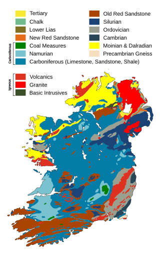
The geology of Ireland consists of the study of the rock formations on the island of Ireland. It includes rocks from every age from Proterozoic to Holocene and a large variety of different rock types is represented. The basalt columns of the Giant's Causeway together with geologically significant sections of the adjacent coast have been declared a World Heritage Site. The geological detail follows the major events in Ireland's past based on the geological timescale.
A ponor is a natural opening where surface water enters into underground passages; they may be found in karst landscapes where the geology and the geomorphology is typically dominated by porous limestone rock. Ponors can drain stream or lake water continuously or can at times work as springs, similar to estavelles. Morphologically, ponors come in forms of large pits and caves, large fissures and caverns, networks of smaller cracks, and sedimentary, alluvial drains.

A solutional cave, solution cave, or karst cave is a cave usually formed in a soluble rock like limestone (Calcium carbonate CaCO3). It is the most frequently occurring type of cave. It can also form in other rocks, including chalk, dolomite, marble, salt beds, and gypsum.

The Cliefden Caves is a heritage-listed geoheritage site at Mandurama, in the Central West region of New South Wales, Australia. The caves comprise Ordovician fossil localities, limestone caves, a spring and tufa dams, and a site where limestone was first discovered in inland Australia.

The geology of Guam formed as a result of mafic, felsic and intermediate composition volcanic rocks erupting below the ocean, building up the base of the island in the Eocene, between 33.9 and 56 million years ago. The island emerged above the water in the Eocene, although the volcanic crater collapsed. A second volcanic crater formed on the south of the island in the Oligocene and Miocene. In the shallow water, numerous limestone formations took shape, with thick alternating layers of volcanic material. The second crater collapsed and Guam went through a period in which it was almost entirely submerged, resembling a swampy atoll, until structural deformation slowly uplifted different parts of the island to their present topography. The process of uplift led to widespread erosion and clay formation, as well as the deposition of different types of limestone, reflecting different water depths.

The Pancake Rocks and Blowholes are a coastal rock formation at Punakaiki on the West Coast of the South Island of New Zealand. They are a popular visitor attraction.
